Credit: Credit: NASA Worldview, Earth Observing System Data and Information System (EOSDIS).
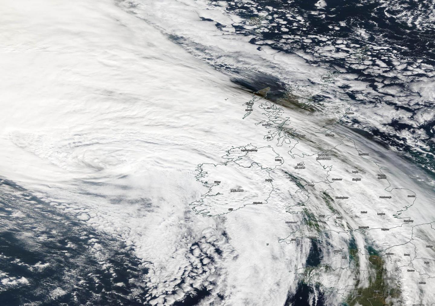
NASA’s Terra satellite passed over the eastern North Atlantic Ocean early on Oct. 3 and captured a visible image of Post-tropical Cyclone Lorenzo as it neared Ireland. Lorenzo’s eastern side is already affecting Ireland, and both Ireland and the United Kingdom have posted warnings today.
On Oct. 3, Lorenzo was still a powerful post-tropical storm. NASA satellite images indicated that frontal features had formed as indicated by its elongated appearance.
The Moderate Imaging Spectroradiometer or MODIS instrument that flies aboard NASA’s Terra satellite provided a visible image of Lorenzo. The MODIS image showed the cloud-filled center of circulation west of Ireland. Clouds and precipitation associated with the system had already spread over Ireland and parts of the United Kingdom.
A Post-Tropical Storm is a generic term for a former tropical cyclone that no longer possesses sufficient tropical characteristics to be considered a tropical cyclone. Three classes of post-tropical cyclones include fully extratropical, subtropical, or remnant lows. In any case, they no longer possesses sufficient tropical characteristics to be considered a tropical cyclone. However, post-tropical cyclones can continue to carry heavy rains and produce high winds.
On Oct. 3, Met Eireann, Ireland’s Meteorological Service issued rainfall and wind warnings for the country. The effects of Post-Tropical Storm Lorenzo will begin to be felt across Ireland this morning. Met Eireann uses three different colors to designate warnings. Yellow means “Not unusual weather. Localised danger.” Orange means “Infrequent. Dangerous/disruptive.” Red means “Rare. Extremely dangerous/destructive.”
A Status Yellow Wind warning is in effect for all of Ireland that calls for southeasterly winds to reach mean speeds 50 to 65 kph (31 to 40 mph) with higher gusts. A Status Yellow Wind warning is in effect for Wexford, Cork, Tipperary and Waterford.
There’s an Orange Wind warning for Galway, Mayo, Clare, Kerry and Limerick. Southwesterly winds veering westerly will reach mean speeds 65 to 80 kph (40 to 50 mph) with gusts generally of 100 to 130 kph (62 to 81 mph), higher in some coastal regions. Storm surges will produce coastal flooding and damage. There is also a Status Orange Gale Warning in effect as southeast gales or strong gales are expected today on all Irish Coastal Waters and on the Irish Sea.
A Status Yellow Rainfall warning for Connacht, Leinster, Cavan, Monaghan and Donegal. That means spells of heavy rain at times today and tonight will result in some flooding.
In coastal areas, Lorenzo will produce significant swells, high waves and sizeable storm surges. This will lead to wave overtopping, some coastal flooding and damage. Met Eireann noted that saturated soils and the expected heavy rainfall may lead to surface flooding. In addition, river levels are currently elevated across the country and the rainfall may lead to river flooding in parts of the midlands, west and northwest.
Hurricanes are the most powerful weather event on Earth. NASA’s expertise in space and scientific exploration contributes to essential services provided to the American people by other federal agencies, such as hurricane weather forecasting.
###
For updated forecasts from Met Eireann, Ireland’s Meteorological Service, Visit: https:/
Media Contact
Rob Gutro
[email protected]
Original Source
https:/


