Credit: NASA/NRL
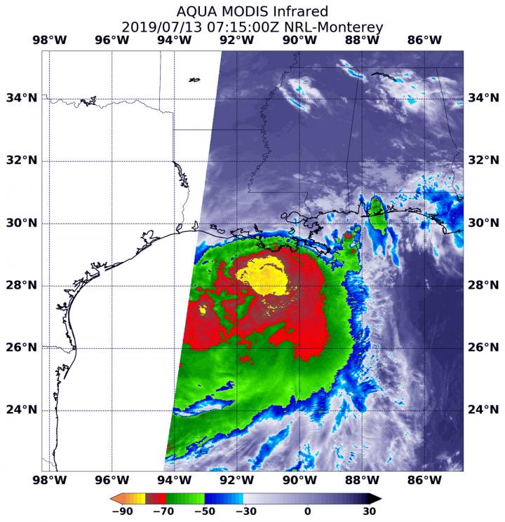
Tropical Storm Barry continued to linger in the Gulf of Mexico, generating a lot of heavy rainfall on Saturday, July 13, 2019. Barry was just under the threshold of being classified a Category 1 hurricane and is expected to become one before landfall. NASA’s Aqua satellite analyzed cloud top temperatures in the storm which gave an indication of the storm’s strength.
At 3:15 a.m. EDT (0715 UTC) on July 13, the MODIS or Moderate Resolution Imaging Spectroradiometer instrument aboard NASA’s Aqua satellite looked at Tropical Strom Barry infrared light. MODIS found coldest cloud tops had temperatures near minus 80 degrees Fahrenheit (minus 62.2 degrees Celsius) south and east around a slightly more rounded center of the tropical storm. Storms with temperatures that cold are indicative of strong storms and have been shown to have the capability to generate heavy rainfall.
The satellite image revealed a large area of strong thunderstorms that cold, surrounded by an even larger area of thunderstorms with cloud tops just slightly less cold. At the time of the image, the largest area of strong storms still appeared to be mostly south of the center of circulation and over the Gulf of Mexico. That’s because wind shear from the north-northwest is still battering the storm and pushing the strongest thunderstorms south and southeast of the center.
Barry’s Status on July 13, 2019
Barry is a strong tropical storm, just below the threshold of a hurricane and is forecast to reach hurricane status before landfalling. At 8 a.m. EDT (1200 UTC), the National Hurricane Center or NHC said the center of Tropical Storm Barry was located near latitude 29.3 North and longitude 91.9 West. Barry is moving toward the northwest near 5 mph (7 km/h), and a turn toward the north is expected tonight or Sunday.
Maximum sustained winds have increased to near 70 mph (115 kph) with higher gusts. Tropical-storm-force winds extend outward up to 175 miles (280 km) from the center.
Additional strengthening is forecast before landfall, and Barry is expected to be a hurricane when the center reaches the Louisiana coast during the next several hours.
Steady weakening is expected after Barry moves inland.
The estimated minimum central pressure based on surface observations is 991 millibars (29.26 inches).
Warnings and Watches in Effect
The NHC posted many warnings and watches for Barry on July 13. A Hurricane Warning is in effect for Intracoastal City to Grand Isle, Louisiana. A Tropical Storm Warning is in effect from the mouth of the Pearl River to Grand Isle, Lake Pontchartrain and Lake Maurepas including metropolitan New Orleans, and from Intracoastal City to Cameron, La.
A Storm Surge Warning is in effect from Intracoastal City, La. to Biloxi, Mississippi and for Lake Pontchartrain. A Storm Surge Watch is in effect from Biloxi, Miss. to the Mississippi/Alabama border. A Hurricane Watch is in effect for the mouth of the Mississippi River to Grand Isle and from Intracoastal City to Cameron, La. A Tropical Storm Watch is in effect from east of the mouth of the Pearl River to the Mississippi / Alabama border.
Landfall in South-Central Louisiana Today
On the forecast track, the National Hurricane Center said the center of Barry will make landfall along the south-central Louisiana coast during the next several hours (after 8 a.m. EDT). After landfall, Barry is expected to move generally northward through the Mississippi Valley through Sunday night.
###
For updated forecasts, visit: http://www.
Rob Gutro
NASA’s Goddard Space Flight Center
Media Contact
Rob Gutro
[email protected]
Original Source
https:/


