Credit: Credit: NASA Worldview, Earth Observing System Data and Information System (EOSDIS)
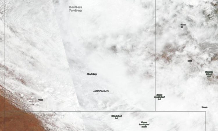
NASA-NOAA’s Suomi NPP satellite provided forecasters with a visible image ex-tropical cyclone Esther’s remnant clouds that have now moved over Australia’s Northern Territory. The remnants have generated a flood watch including in the Tanami and Central Deserts.
Visible imagery from satellites help forecasters understand if a storm is organizing or weakening and the extent and movement of the storm. The Visible Infrared Imaging Radiometer Suite (VIIRS) instrument aboard Suomi NPP provided an image on Mar. 3 that showed the remnant clouds and storms associated with the ex-tropical cyclone have blanketed the Northern Territory. The center of ex-tropical cyclone Esther is located over the northern Tanami District.
On March 3, the Australian Bureau of Meteorology (ABM), Northern Territory issued a Flood Watch for the Tanami Desert, Central Desert, MacDonnell Ranges, Barkly, Georgina River and Simpson Desert. A flood warning was in effect for Sturt Creek District in Western Australia.
ABM noted widespread rainfall totals of 50 to 100 mm (~2 to 4 inches) have been recorded throughout the northern Tanami Desert. Some isolated areas received as much as 190 mm (7.5 inches).
ABM said, “Rainfall is expected to increase in the Central Desert and southeastern Tanami Desert from today with widespread falls of 70 to120 mm (2.8 to 4.7 inches) expected. Isolated falls of 180 mm (7 inches) could also be possible in places. Rainfall is also expected to increase in the MacDonnell Ranges and southern Barkly during today with 40 to 100 mm (1.6 to 4 inches) daily totals expected into tomorrow. Rainfall extends to the upper Georgina River and Simpson Desert during tomorrow with daily rainfall totals 20 to 80 mm (0.8 to 3.1 inches) expected in many areas.”
Esther is forecast to move southeast across the southern Barkly area to the Simpson District by Mar. 4.
Many roads including major transport routes in the flood watch area will continue to be affected and become or remain impassable with some communities and homesteads becoming isolated.
Tropical cyclones/hurricanes are the most powerful weather events on Earth. NASA’s expertise in space and scientific exploration contributes to essential services provided to the American people by other federal agencies, such as hurricane weather forecasting.
For updated forecasts from ABM, visit: http://www.
###
By Rob Gutro
NASA’s Goddard Space Flight Center
Media Contact
Rob Gutro
[email protected]
Original Source
https:/


