• HOME
  • NEWS
  • EXPLORE
    • CAREER
      • Companies
      • Jobs
    • EVENTS
    • iGEM
      • News
      • Team
    • PHOTOS
    • VIDEO
    • WIKI
  • BLOG
  • COMMUNITY
    • FACEBOOK
    • INSTAGRAM
    • TWITTER
Thursday, May 21, 2026
BIOENGINEER.ORG
No Result
View All Result
  • Login
  • HOME
  • NEWS
  • EXPLORE
    • CAREER
      • Companies
      • Jobs
        • Lecturer
        • PhD Studentship
        • Postdoc
        • Research Assistant
    • EVENTS
    • iGEM
      • News
      • Team
    • PHOTOS
    • VIDEO
    • WIKI
  • BLOG
  • COMMUNITY
    • FACEBOOK
    • INSTAGRAM
    • TWITTER
  • HOME
  • NEWS
  • EXPLORE
    • CAREER
      • Companies
      • Jobs
        • Lecturer
        • PhD Studentship
        • Postdoc
        • Research Assistant
    • EVENTS
    • iGEM
      • News
      • Team
    • PHOTOS
    • VIDEO
    • WIKI
  • BLOG
  • COMMUNITY
    • FACEBOOK
    • INSTAGRAM
    • TWITTER
No Result
View All Result
Bioengineer.org
No Result
View All Result
Home NEWS Science News

NASA sees Ex-Tropical Cyclone 03S resemble a frontal system

Bioengineer by Bioengineer
January 30, 2017
in Science News
Reading Time: 2 mins read
0
Share on FacebookShare on TwitterShare on LinkedinShare on RedditShare on Telegram
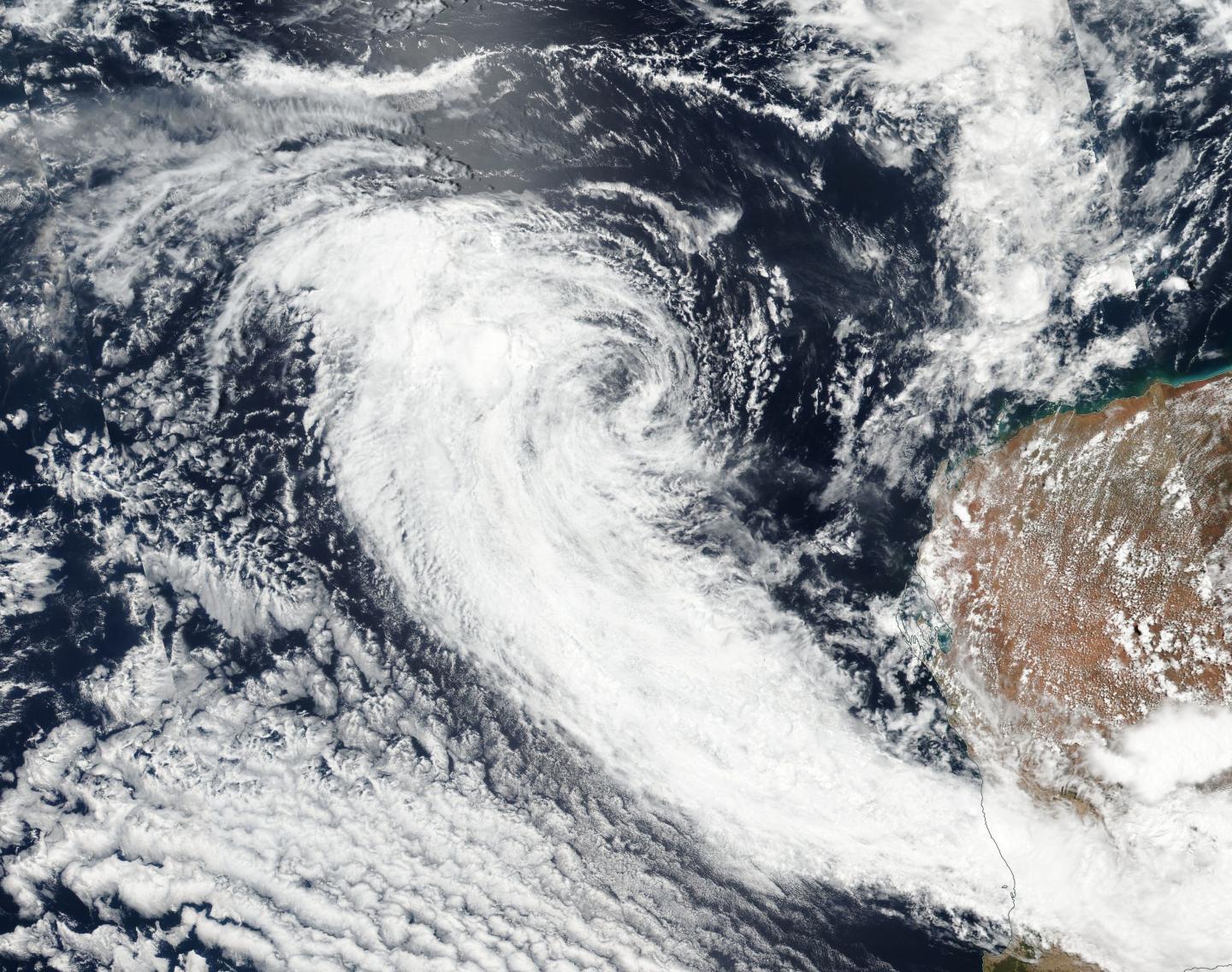
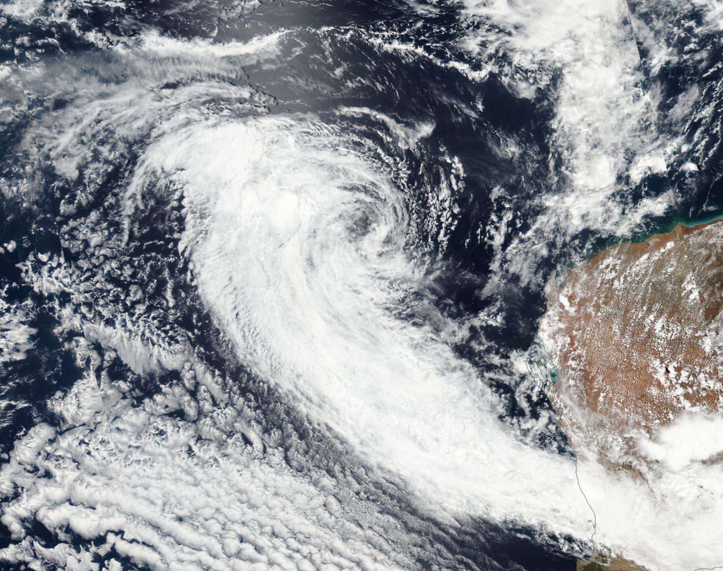
IMAGE

Credit: Credits: NASA Goddard MODIS Rapid Response

Satellite data from NASA-NOAA's Suomi NPP satellite showed that former Tropical Cyclone 03S resembled a frontal system in the Southern Indian Ocean as it continued moving in a northwesterly direction over cooler sea surface temperatures.

The Joint Typhoon Warning Center or JTWC issued their final warning on the system at 4 a.m. EST (0900 UTC) on January 29, when 03S' maximum sustained winds dropped to 30 knots. At that time, it was about 310 nautical miles northwest of Learmonth, Western Australia. Infrared imagery from the MODIS instrument aboard NASA's Aqua satellite on Jan 29 at 0720 UTC (2:20 a.m. EST) showed that the system appeared elongated.

On Jan. 30, the Visible Infrared Imaging Radiometer Suite (VIIRS) instrument aboard NASA-NOAA's Suomi NPP satellite provided a visible-light image of Ex-Tropical Cyclone 03S that showed its circulation center was being battered by vertical wind shear. That wind shear pushed most of the clouds and thunderstorms west and southwest of the center. The image showed that those clouds were streaming to the southeast, being drawn between a low pressure center over the western part of Western Australia and a high pressure system located to the south-southwest of 03S's remnant center. As a result, the clouds resemble a frontal system over the southern section of Western Australia. Some of the storms associated with that system have triggered warnings on January 30.

The Australian Bureau of Meteorology issued a warning to "Sheep Graziers for the Lower West (where the city of Perth is located) and Great Southern forecast districts" on 5:03 p.m. WST local time on Monday 30 January 2017. The warning stated "Sheep graziers are warned that cold temperatures for this time of year, heavy rain at times and easterly winds are expected during the remainder of Monday and Tuesday. Areas likely to be affected include parts of the Lower West and northern parts of the Great Southern forecast districts. There is a risk of losses of lambs and sheep exposed to these conditions."

JTWC said that the remnant low pressure area will continue to weaken due to unfavorable environmental conditions.

###

Media Contact

Rob Gutro
[email protected]
@NASAGoddard

http://www.nasa.gov/goddard

############

Story Source: Materials provided by Scienmag

Share12Tweet8Share2ShareShareShare2

Related Posts

Innovative Reusable Brick Walls Revolutionize Construction Industry — Technology and Engineering

Innovative Reusable Brick Walls Revolutionize Construction Industry

May 21, 2026

Nonlinear Atomic Tunneling Enhanced by Bright Squeezed Vacuum

May 21, 2026

Label-Free Super-Resolution Imaging of Live Cells

May 21, 2026

Genetic Insights from 619,372 Metabolic Profiles

May 21, 2026
Please login to join discussion

POPULAR NEWS

  • blank

    New Study Reveals Plants Can Detect the Sound of Rain

    733 shares
    Share 292 Tweet 183
  • ESMO 2025: mRNA COVID Vaccines Enhance Efficacy of Cancer Immunotherapy

    304 shares
    Share 122 Tweet 76
  • Research Indicates Potential Connection Between Prenatal Medication Exposure and Elevated Autism Risk

    846 shares
    Share 338 Tweet 212
  • Breastmilk Balances E. coli and Beneficial Bacteria in Infant Gut Microbiomes

    58 shares
    Share 23 Tweet 15

About

We bring you the latest biotechnology news from best research centers and universities around the world. Check our website.

Follow us

Recent News

Innovative Reusable Brick Walls Revolutionize Construction Industry

Nonlinear Atomic Tunneling Enhanced by Bright Squeezed Vacuum

Label-Free Super-Resolution Imaging of Live Cells

Subscribe to Blog via Email

Enter your email address to subscribe to this blog and receive notifications of new posts by email.

Join 82 other subscribers
  • Contact Us

Bioengineer.org © Copyright 2023 All Rights Reserved.

Welcome Back!

Login to your account below

Forgotten Password?

Retrieve your password

Please enter your username or email address to reset your password.

Log In
No Result
View All Result
  • Homepages
    • Home Page 1
    • Home Page 2
  • News
  • National
  • Business
  • Health
  • Lifestyle
  • Science

Bioengineer.org © Copyright 2023 All Rights Reserved.