• HOME
  • NEWS
  • EXPLORE
    • CAREER
      • Companies
      • Jobs
    • EVENTS
    • iGEM
      • News
      • Team
    • PHOTOS
    • VIDEO
    • WIKI
  • BLOG
  • COMMUNITY
    • FACEBOOK
    • INSTAGRAM
    • TWITTER
Friday, December 19, 2025
BIOENGINEER.ORG
No Result
View All Result
  • Login
  • HOME
  • NEWS
  • EXPLORE
    • CAREER
      • Companies
      • Jobs
        • Lecturer
        • PhD Studentship
        • Postdoc
        • Research Assistant
    • EVENTS
    • iGEM
      • News
      • Team
    • PHOTOS
    • VIDEO
    • WIKI
  • BLOG
  • COMMUNITY
    • FACEBOOK
    • INSTAGRAM
    • TWITTER
No Result
View All Result
Bioengineer.org
No Result
View All Result
Home NEWS Science News

NASA sees compact Douglas strengthening to a major hurricane

Bioengineer by Bioengineer
July 23, 2020
in Science News
Reading Time: 2 mins read
0
IMAGE
Share on FacebookShare on TwitterShare on LinkedinShare on RedditShare on Telegram

IMAGE

Credit: Credit: NASA/NRL

Although a compact storm, hurricane Douglas in the Eastern Pacific is mighty, as it has become the season’s first major hurricane. NASA-NOAA’s Suomi NPP satellite provided forecasters with an image of Douglas that showed development of an eye as it quickly intensified.

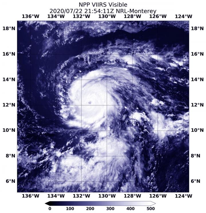
Early on July 22, Douglas was still a tropical storm. By 11 a.m. EDT (1500 UTC) it had strengthened into a hurricane. At 5:54 p.m. EDT (2154 UTC), the Visible Infrared Imaging Radiometer Suite (VIIRS) instrument aboard Suomi NPP revealed that the storm developed an eye. VIIRS showed that powerful bands of thunderstorms had circled the eye. Bands of thunderstorms were spiraling into the low-level center from the northern and southern quadrants. There was an indication that only a little dry air that earlier affected the storm, remained. What little dry air there was, stretched across the northern portion of the circulation, which was limiting the amount of deep convection wrapping around that part of the eye.

By July 23 at 5 a.m. EDT (0900 UTC), Douglas had rapidly intensified into a major hurricane. Maximum sustained winds have increased to near 120 mph (195 kph) with higher gusts.  Douglas is a category 3 hurricane on the Saffir-Simpson Hurricane Wind Scale. Hurricane-force winds extend outward up to 25 miles (35 km) from the center and tropical-storm-force winds extend outward up to 105 miles (165 km).

The center of Hurricane Douglas was located near latitude 13.1 degrees north and longitude 134.0 degrees west. That is about 1,470 miles (2,365 km) east-southeast of Hilo, Hawaii. Douglas was moving toward the west-northwest near 17 mph (28 kph) and this general motion is expected to continue through Saturday. The estimated minimum central pressure was 967 millibars.

Satellite data on July 23 at 5 a.m. EDT showed Douglas had a ragged but nearly clear eye surrounded by cold cloud tops of minus 70 degrees Celsius (minus 94 degrees Fahrenheit), indicating very powerful thunderstorms.

NHC forecasters note that some additional strengthening is possible on Thursday.  Gradual weakening is forecast to begin by early Friday. Interests in the Hawaiian Islands should monitor the progress of Douglas.

Tropical cyclones/hurricanes are the most powerful weather events on Earth. NASA’s expertise in space and scientific exploration contributes to essential services provided to the American people by other federal agencies, such as hurricane weather forecasting.

###

For updated forecasts, visit: http://www.nhc.noaa.gov

By Rob Gutro 

NASA’s Goddard Space Flight Center

Media Contact
Rob Gutro
[email protected]

Original Source

https://blogs.nasa.gov/hurricanes/2020/07/23/douglas-eastern-pacific-ocean-3/

Tags: Atmospheric ChemistryAtmospheric ScienceClimate ChangeClimate ScienceEarth ScienceMeteorologyTechnology/Engineering/Computer ScienceTemperature-Dependent PhenomenaWeather/Storms
Share12Tweet8Share2ShareShareShare2

Related Posts

K-Wire’s Role in Preventing Hinge Fractures Explored

December 19, 2025
blank

Bridging Fundamental Research and Applications in Lithium CO2 Batteries

December 19, 2025

Rhno1 Deletion Impairs DNA Damage Response in Mice

December 19, 2025

Recombination Junctions Reveal Immune and DNA Repair Defects

December 19, 2025
Please login to join discussion

POPULAR NEWS

  • Nurses’ Views on Online Learning: Effects on Performance

    Nurses’ Views on Online Learning: Effects on Performance

    70 shares
    Share 28 Tweet 18
  • NSF funds machine-learning research at UNO and UNL to study energy requirements of walking in older adults

    70 shares
    Share 28 Tweet 18
  • Unraveling Levofloxacin’s Impact on Brain Function

    53 shares
    Share 21 Tweet 13
  • MoCK2 Kinase Shapes Mitochondrial Dynamics in Rice Fungal Pathogen

    72 shares
    Share 29 Tweet 18

About

We bring you the latest biotechnology news from best research centers and universities around the world. Check our website.

Follow us

Recent News

K-Wire’s Role in Preventing Hinge Fractures Explored

Bridging Fundamental Research and Applications in Lithium CO2 Batteries

Rhno1 Deletion Impairs DNA Damage Response in Mice

Subscribe to Blog via Email

Enter your email address to subscribe to this blog and receive notifications of new posts by email.

Join 70 other subscribers
  • Contact Us

Bioengineer.org © Copyright 2023 All Rights Reserved.

Welcome Back!

Login to your account below

Forgotten Password?

Retrieve your password

Please enter your username or email address to reset your password.

Log In
No Result
View All Result
  • Homepages
    • Home Page 1
    • Home Page 2
  • News
  • National
  • Business
  • Health
  • Lifestyle
  • Science

Bioengineer.org © Copyright 2023 All Rights Reserved.