• HOME
  • NEWS
  • EXPLORE
    • CAREER
      • Companies
      • Jobs
    • EVENTS
    • iGEM
      • News
      • Team
    • PHOTOS
    • VIDEO
    • WIKI
  • BLOG
  • COMMUNITY
    • FACEBOOK
    • INSTAGRAM
    • TWITTER
Monday, September 1, 2025
BIOENGINEER.ORG
No Result
View All Result
  • Login
  • HOME
  • NEWS
  • EXPLORE
    • CAREER
      • Companies
      • Jobs
        • Lecturer
        • PhD Studentship
        • Postdoc
        • Research Assistant
    • EVENTS
    • iGEM
      • News
      • Team
    • PHOTOS
    • VIDEO
    • WIKI
  • BLOG
  • COMMUNITY
    • FACEBOOK
    • INSTAGRAM
    • TWITTER
No Result
View All Result
Bioengineer.org
No Result
View All Result
Home NEWS Science News

NASA satellite shows Typhoon Mitag’s large reach over East China Sea

Bioengineer by Bioengineer
October 1, 2019
in Science News
Reading Time: 2 mins read
0
Share on FacebookShare on TwitterShare on LinkedinShare on RedditShare on Telegram

IMAGE

Credit: Credit: NASA Worldview, Earth Observing System Data and Information System (EOSDIS)

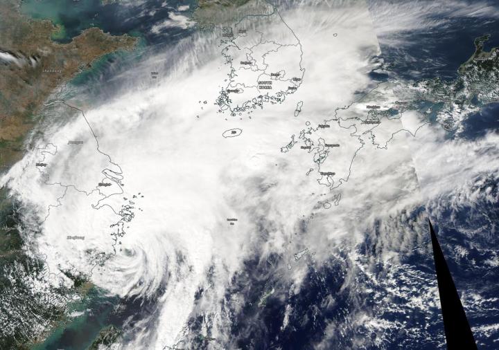
The bulk of Typhoon Mitag’s clouds and precipitation has been pushed north of its center, extending its reach over the East China Sea. Mitag was centered just off the coast of China’s Zhejiang province when NASA-NOAA’s Suomi NPP satellite passed overhead, but the bulk of the clouds were pushed north of center to the Korean Peninsula and southern Japan.

The Visible Infrared Imaging Radiometer Suite (VIIRS) instrument aboard Suomi NPP provided a visible image of Mitag on Oct. 1, showing its eye was just off the coast of China’s Zhejiang province in the East China Sea. The VIIRS image revealed some bands of thunderstorms wrapped around the partially-exposed, ragged low-level center of circulation off the China coast.

The main area of deep convection (rising air that forms thunderstorms that make up a tropical cyclone) and thunderstorms is located north of center and had decoupled from the center. That decoupled area of storms extended northeast to the Korean Peninsula and to Kyushu, the southwestern most of Japan’s main islands.

Visible imagery from NASA satellites helps forecasters understand if a storm is organizing or weakening. The shape of a tropical cyclone provides forecasters with an idea of its organization and strength. The more circular a storm appears, the stronger it can be. Because the bulk of Mitag’s clouds and showers are pushed north of the center, it appears to be weakening. The image was created by the NASA Worldview Earth Observing System Data and Information System (EOSDIS) at NASA’s Goddard Space Flight Center in Greenbelt, Md.

On Oct. 1, the China Meteorological Administration posted several warnings including Typhoon Warning, and warnings for heavy rain. Those warnings can be found at: http://www.cma.gov.cn/en2014/weather/Warnings/WarningSignals/201409/t20140919_261777.html

At 5 a.m. EDT (0900 UTC) on Oct. 1, Typhoon Mitag had maximum sustained winds near 65 knots (75 mph/120 kph). It was centered near 28.7 degrees north latitude and 122.3 degrees east longitude, about 156 nautical miles south-southeast of Shanghai, China. Mitag is moving north. Forecasters at the Joint Typhoon Warning Center expect Mitag will turn to the northeast and pass over South Korea while weakening. It is expected to become extra-tropical in the Sea of Japan.

Hurricanes are the most powerful weather event on Earth. NASA’s expertise in space and scientific exploration contributes to essential services provided to the American people by other federal agencies, such as hurricane weather forecasting.

###

Media Contact
Rob Gutro
[email protected]

Original Source

https://blogs.nasa.gov/hurricanes/2019/10/01/mitag-northwestern-pacific-ocean-2/

Tags: Atmospheric ChemistryAtmospheric ScienceClimate ChangeClimate ScienceEarth ScienceMeteorologyTechnology/Engineering/Computer ScienceTemperature-Dependent PhenomenaWeather/Storms
Share13Tweet8Share2ShareShareShare2

Related Posts

Tailored Risk Messages Show No Impact on Increasing Colorectal Cancer Screening Rates

September 1, 2025

New Predictive Model for Postpartum Hemorrhage in Cesarean Cases

September 1, 2025

Novel ADC Targets Fucosyl-GM1 in Lung Cancer

September 1, 2025

AI-Powered Adaptive Tutoring for Moodle: A Breakthrough

September 1, 2025
Please login to join discussion

POPULAR NEWS

  • blank

    Breakthrough in Computer Hardware Advances Solves Complex Optimization Challenges

    153 shares
    Share 61 Tweet 38
  • Molecules in Focus: Capturing the Timeless Dance of Particles

    143 shares
    Share 57 Tweet 36
  • New Drug Formulation Transforms Intravenous Treatments into Rapid Injections

    117 shares
    Share 47 Tweet 29
  • Do people and monkeys see colors the same way?

    112 shares
    Share 45 Tweet 28

About

We bring you the latest biotechnology news from best research centers and universities around the world. Check our website.

Follow us

Recent News

Tailored Risk Messages Show No Impact on Increasing Colorectal Cancer Screening Rates

New Predictive Model for Postpartum Hemorrhage in Cesarean Cases

Novel ADC Targets Fucosyl-GM1 in Lung Cancer

  • Contact Us

Bioengineer.org © Copyright 2023 All Rights Reserved.

Welcome Back!

Login to your account below

Forgotten Password?

Retrieve your password

Please enter your username or email address to reset your password.

Log In
No Result
View All Result
  • Homepages
    • Home Page 1
    • Home Page 2
  • News
  • National
  • Business
  • Health
  • Lifestyle
  • Science

Bioengineer.org © Copyright 2023 All Rights Reserved.