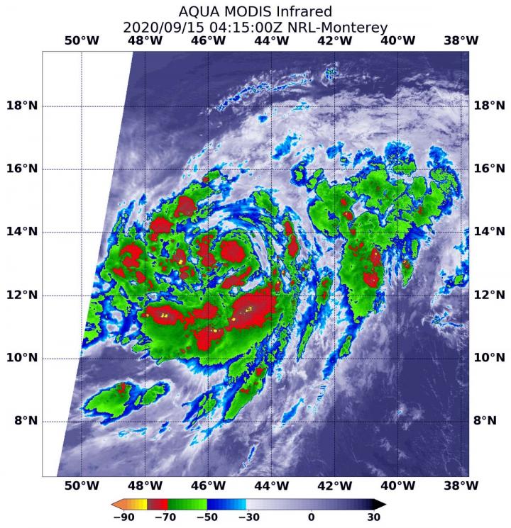
Credit: NASA/NRL
When a tropical cyclone consolidates, it means that it is getting more organized and its circulation is improving. An improved circulation helps make for a stronger storm. Infrared imagery from NASA’s Aqua satellite showed that Teddy was consolidating in the Central North Atlantic Ocean.
Infrared Data Reveals Teddy is organizing
On Sept. 15 at 12:15 a.m. EDT (0415 UTC), the Moderate Resolution Imaging Spectroradiometer or MODIS instrument aboard NASA’s Aqua satellite gathered temperature information about Teddy’s cloud tops. Infrared data provides temperature information, and the strongest thunderstorms that reach high into the atmosphere have the coldest cloud top temperatures.
MODIS found some cloud top temperatures were as cold as or colder than minus 70 degrees Fahrenheit (minus 56.6 Celsius). Cloud top temperatures that cold indicate strong storms with the potential to generate heavy rainfall. The infrared data showed that Teddy’s structure is slowly improving. The infrared imagery and visible imagery revealed that the building of thunderstorms around the storm’s core has increased, despite the continued presence of dry slots.
Teddy’s Status on Sept. 15
At 11 a.m. EDT (1500 UTC), the center of Tropical Storm Teddy was located near latitude 14.0 degrees north and longitude 47.0 degrees west. Teddy is located about 960 miles (1,545 km) east of the Lesser Antilles. Teddy is moving toward the west-northwest near 13 mph (20 kph). A steady northwest motion at 10 to 15 mph is expected through the end of the week.
Maximum sustained winds have increased to near 65 mph (100 kph) with higher gusts. Additional strengthening is forecast for the next several days. Teddy will likely become a hurricane later today or tonight and could reach major hurricane strength in a few days. The estimated minimum central pressure is 999 millibars.
Teddy’s Forecast
“Teddy’s low [wind] shear and warm sea surface temperature environment should be conducive for further strengthening, and the NHC intensity forecast is largely unchanged,” noted David Zelinsky, Hurricane Model Diagnostician and Meteorologist at the NHC. “Some dry air in the environment could restrict Teddy’s intensification rate, but is not expected to prevent Teddy from becoming a hurricane later today or tonight. Continued strengthening is expected thereafter and Teddy is forecast to become a major hurricane within the next few days.”
###
NASA Researches Tropical Cyclones
Hurricanes/tropical cyclones are the most powerful weather events on Earth. NASA’s expertise in space and scientific exploration contributes to essential services provided to the American people by other federal agencies, such as hurricane weather forecasting.
NASA’s Aqua satellite is one in a fleet of NASA satellites that provide data for hurricane research.
For more than five decades, NASA has used the vantage point of space to understand and explore our home planet, improve lives and safeguard our future. NASA brings together technology, science, and unique global Earth observations to provide societal benefits and strengthen our nation. Advancing knowledge of our home planet contributes directly to America’s leadership in space and scientific exploration.
For updated forecasts, visit: http://www.
By Rob Gutro
NASA’s Goddard Space Flight Center
Media Contact
Rob Gutro
[email protected]
Original Source
https:/


