Credit: Credit: NASA Worldview
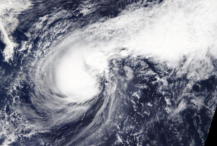
Typhoon Halong has packed quite a punch and imagery from NASA’s Terra satellite found that the storm resembled a boxing glove.
On Nov. 7, NASA’s Terra satellite passed over the northwestern Pacific Ocean and the Moderate Resolution Imaging Spectroradiometer or MODIS instrument that flies aboard captured a visible image of Halong. The MODIS image showed powerful thunderstorms circling the center of circulation and a band of thunderstorms northeast of center. Combined, the storm looked like a boxing glove from space with the “thumb” as the band of storms that curved to the east of the center. Satellite imagery using microwaves revealed that there is an eye under that large area of thunderstorms circling the center.
At 10 a.m. EST (1500 UTC) on Nov. 7, the center of Typhoon Halong was located near latitude 24.8 degrees north and longitude 152.2 degrees east. That puts the center about 110 nautical miles west of Minami Tori Shima, Japan. Maximum sustained winds were near 90 knots (104 mph/167 kph).
The Joint Typhoon Warning Center or JTWC noted, “Halong will accelerate poleward [north] while gradually turning northeastward to east-northeastward. The environment will become more unfavorable with increasing vertical wind shear and cooling sea surface temperatures.” That means the storm will experience a weakening trend and after a day, the storm is expected to start transitioning into an extra-tropical storm.
Typhoons and hurricanes are the most powerful weather event on Earth. NASA’s expertise in space and scientific exploration contributes to essential services provided to the American people by other federal agencies, such as hurricane weather forecasting.
###
Media Contact
Rob Gutro
[email protected]
Original Source
https:/


