Credit: Credit: NASA Worldview, Earth Observing System Data and Information System (EOSDIS)
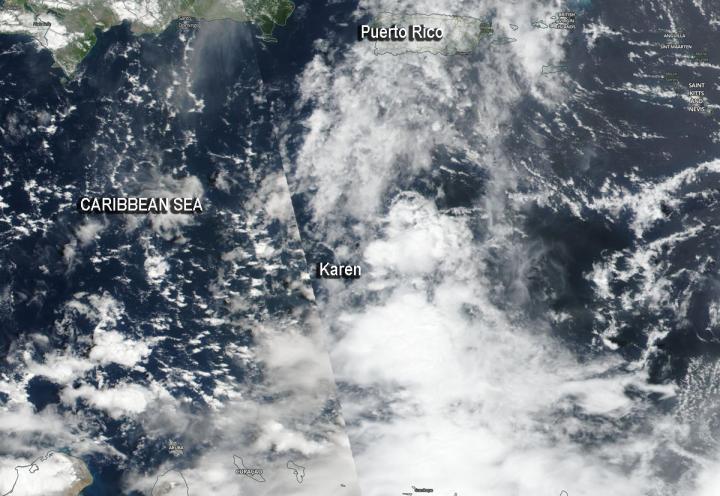
Satellite imagery can be used to peer inside a storm as well as assess the storm’s outside shape to give forecasters understanding of what’s happening to it. NASA-NOAA’s Suomi NPP satellite provided forecasters with a visible image of a less-organized Karen after it moved into the Caribbean Sea and encountered wind shear.
On Sunday, Sept. 22 at 5 a.m. EDT, NOAA’s National Hurricane Center said that Tropical Storm Karen formed just east of the Windward Islands. Twelve hours later, it had moved into the Caribbean Sea.
The shape of a tropical cyclone provides forecasters with an idea of its organization and strength. Imagery from Suomi NPP showed Karen had become less organized after it moved west from the Atlantic Ocean into the southeastern Caribbean Sea.
When outside winds batter a storm, it can change the shape of it and push much of the associated clouds and rain to one side of it. That’s what wind shear does. Karen encountered northeasterly wind shear when it moved into the Caribbean Sea and those winds continued to affect Karen on Sept. 23.
In general, wind shear is a measure of how the speed and direction of winds change with altitude. Tropical cyclones are like rotating cylinders of winds. Each level needs to be stacked on top each other vertically in order for the storm to maintain strength or intensify. Wind shear occurs when winds at different levels of the atmosphere push against the rotating cylinder of winds, weakening the rotation by pushing it apart at different levels.
The Visible Infrared Imaging Radiometer Suite (VIIRS) instrument aboard Suomi NPP provided a visible image of Karen on Sept. 22. The Suomi NPP image revealed that the structure of Karen’s thunderstorms continued to lose organization during the afternoon hours and that the center become exposed to the north and northwest of the band of thunderstorms.
NOAA’s National Hurricane Center or NHC noted on Sept. 23 that despite Karen’s disorganized appearance, it is expected to bring heavy rains and gusty winds to Puerto Rico and the Virgin Islands. A Tropical Storm Warning is in effect for the U.S. Virgin Islands, Puerto Rico, including Vieques and Culebra, and British Virgin Islands.
At 11 a.m. EDT (1500 UTC), the center of Tropical Storm Karen was located near latitude 14.9 degrees north, and longitude 64.8 degrees west. Karen was about 255 miles (415 km) south-southeast of San Juan, Puerto Rico. Karen is moving toward the north-northwest near 12 mph (19 km/h), and this general motion is forecast to continue today. A turn toward the north is expected by Tuesday. Maximum sustained winds are near 40 mph (65 kph) with higher gusts. Little overall change in strength is forecast during the next 48 hours. Tropical-storm-force winds extend outward up to 105 miles (165 km) from the center. The estimated minimum central pressure is 1007 millibars.
On the forecast track, the center of Karen will pass near or over Puerto Rico and the Virgin Islands Tuesday morning, Sept. 24. Karen will move over the western Atlantic to the north of Puerto Rico on Tuesday night and Wednesday.
Hurricanes are the most powerful weather event on Earth. NASA’s expertise in space and scientific exploration contributes to essential services provided to the American people by other federal agencies, such as hurricane weather forecasting.
For updated forecasts. visit: http://www.
###
Media Contact
Rob Gutro
[email protected]
Original Source
https:/


