• HOME
  • NEWS
  • EXPLORE
    • CAREER
      • Companies
      • Jobs
    • EVENTS
    • iGEM
      • News
      • Team
    • PHOTOS
    • VIDEO
    • WIKI
  • BLOG
  • COMMUNITY
    • FACEBOOK
    • INSTAGRAM
    • TWITTER
Monday, December 1, 2025
BIOENGINEER.ORG
No Result
View All Result
  • Login
  • HOME
  • NEWS
  • EXPLORE
    • CAREER
      • Companies
      • Jobs
        • Lecturer
        • PhD Studentship
        • Postdoc
        • Research Assistant
    • EVENTS
    • iGEM
      • News
      • Team
    • PHOTOS
    • VIDEO
    • WIKI
  • BLOG
  • COMMUNITY
    • FACEBOOK
    • INSTAGRAM
    • TWITTER
No Result
View All Result
Bioengineer.org
No Result
View All Result
Home NEWS Science News

NASA satellite finds wind shear adversely affecting tropical storm Francisco

Bioengineer by Bioengineer
February 6, 2020
in Science News
Reading Time: 2 mins read
0
IMAGE
Share on FacebookShare on TwitterShare on LinkedinShare on RedditShare on Telegram

IMAGE

Credit: Credit: NASA Worldview, Earth Observing System Data and Information System (EOSDIS)


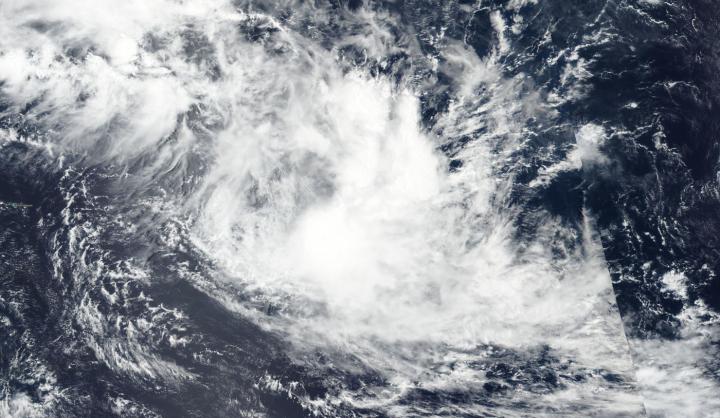
Forecasters use a variety of satellite imagery to understand what is happening in a storm, and sometimes just a visible picture can tell a lot. NASA-NOAA’s Suomi NPP satellite provided forecasters with a visible image of the Tropical Storm Francisco in the Southern Indian Ocean that showed wind shear was pushing clouds away from the storm’s center.

Visible imagery from satellites helps forecasters understand if a storm is organizing or weakening, or if it is being affected by vertical wind shear. The shape of a tropical cyclone provides forecasters with an idea of its organization and strength. When outside winds, that is, vertical wind shear, batter a storm it can change the shape of it and push much of the associated clouds and rains to one side of it.

In general, wind shear is a measure of how the speed and direction of winds change with altitude. Tropical cyclones are like rotating cylinders of winds. Each level needs to be stacked on top each other vertically in order for the storm to maintain strength or intensify. Wind shear occurs when winds at different levels of the atmosphere push against the rotating cylinder of winds, weakening the rotation by pushing it apart at different levels.

The Visible Infrared Imaging Radiometer Suite (VIIRS) instrument aboard Suomi NPP provided a visible image of Francisco on Feb. 6. The image showed vertical wind shear is displacing the deep convection about 125 nautical miles to the southeast. In addition, multispectral satellite imagery revealed that the low-level circulation center appeared elongated. When the circulation is not circular and appears elongated, it cannot spin as quickly, just like a tire. Thus, the storm weakens. Wind shear is causing the elongation and weakening the storm.

At 4 a.m. EDT (0900 UTC), the Joint Typhoon Warning Center (JTWC) issued their final advisory on Tropical Cyclone Francisco. At that time, Francisco was located near latitude 19.1 degrees south and longitude 71.7 degrees east, about 816 nautical miles east of Port Louis, Mauritius and moving southeast. Maximum sustained winds were near 35 knots (40 mph/65 kph) and weakening.

The JTWC expects Francisco will continue moving to the southeast until it dissipates.

Tropical cyclones/hurricanes are the most powerful weather events on Earth. NASA’s expertise in space and scientific exploration contributes to essential services provided to the American people by other federal agencies, such as hurricane weather forecasting.

###

By Rob Gutro 

NASA’s Goddard Space Flight Center

Media Contact
Rob Gutro
[email protected]

Original Source

https://blogs.nasa.gov/hurricanes/2020/02/06/francisco-southern-indian-ocean-2/

Tags: Atmospheric ChemistryAtmospheric ScienceClimate ChangeClimate ScienceEarth ScienceMeteorologyTechnology/Engineering/Computer ScienceTemperature-Dependent PhenomenaWeather/Storms
Share12Tweet8Share2ShareShareShare2

Related Posts

Tibial Nerve Techniques Boost Diabetic Neuropathy Recovery

November 30, 2025

Exploring West Africa’s Health Policy Collaboration Networks

November 30, 2025

Adipose Progenitor Cell Variations in Bovine Fats

November 30, 2025

Türkiye Earthquake: Nursing Workforce Crisis and Solutions

November 30, 2025
Please login to join discussion

POPULAR NEWS

  • New Research Unveils the Pathway for CEOs to Achieve Social Media Stardom

    New Research Unveils the Pathway for CEOs to Achieve Social Media Stardom

    203 shares
    Share 81 Tweet 51
  • Scientists Uncover Chameleon’s Telephone-Cord-Like Optic Nerves, A Feature Missed by Aristotle and Newton

    120 shares
    Share 48 Tweet 30
  • Neurological Impacts of COVID and MIS-C in Children

    106 shares
    Share 42 Tweet 27
  • MoCK2 Kinase Shapes Mitochondrial Dynamics in Rice Fungal Pathogen

    66 shares
    Share 26 Tweet 17

About

We bring you the latest biotechnology news from best research centers and universities around the world. Check our website.

Follow us

Recent News

Tibial Nerve Techniques Boost Diabetic Neuropathy Recovery

Exploring West Africa’s Health Policy Collaboration Networks

Adipose Progenitor Cell Variations in Bovine Fats

Subscribe to Blog via Email

Enter your email address to subscribe to this blog and receive notifications of new posts by email.

Join 69 other subscribers
  • Contact Us

Bioengineer.org © Copyright 2023 All Rights Reserved.

Welcome Back!

Login to your account below

Forgotten Password?

Retrieve your password

Please enter your username or email address to reset your password.

Log In
No Result
View All Result
  • Homepages
    • Home Page 1
    • Home Page 2
  • News
  • National
  • Business
  • Health
  • Lifestyle
  • Science

Bioengineer.org © Copyright 2023 All Rights Reserved.