• HOME
  • NEWS
  • EXPLORE
    • CAREER
      • Companies
      • Jobs
    • EVENTS
    • iGEM
      • News
      • Team
    • PHOTOS
    • VIDEO
    • WIKI
  • BLOG
  • COMMUNITY
    • FACEBOOK
    • INSTAGRAM
    • TWITTER
Wednesday, December 17, 2025
BIOENGINEER.ORG
No Result
View All Result
  • Login
  • HOME
  • NEWS
  • EXPLORE
    • CAREER
      • Companies
      • Jobs
        • Lecturer
        • PhD Studentship
        • Postdoc
        • Research Assistant
    • EVENTS
    • iGEM
      • News
      • Team
    • PHOTOS
    • VIDEO
    • WIKI
  • BLOG
  • COMMUNITY
    • FACEBOOK
    • INSTAGRAM
    • TWITTER
No Result
View All Result
Bioengineer.org
No Result
View All Result
Home NEWS Science News

NASA Satellite finds Karen holding onto tropical storm status

Bioengineer by Bioengineer
September 27, 2019
in Science News
Reading Time: 2 mins read
0
IMAGE
Share on FacebookShare on TwitterShare on LinkedinShare on RedditShare on Telegram

IMAGE

Credit: NASA Worldview, Earth Observing System Data and Information System (EOSDIS)

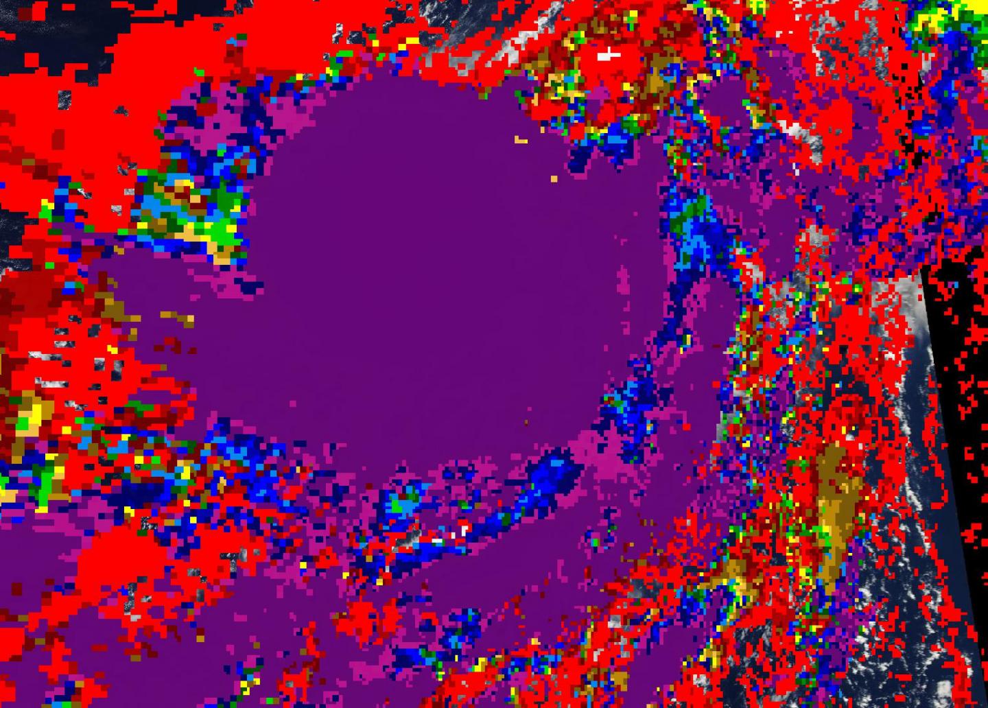
NASA’s Terra Satellite provides a variety of data on tropical cyclones including cloud heights and cloud top temperatures. Terra examined those factors in Tropical Storm Karen in the North Atlantic Ocean and data showed Karen holding onto tropical storm status.

Tropical cyclones are made up of hundreds of thunderstorms. By analyzing the heights of thunderstorms and their cloud top temperatures, forecasters can tell if a storm is strengthening or weakening. The higher the cloud tops, the stronger the uplift in a storm. That rising air helps thunderstorms develop.  As storms go higher, it is an indication that the storm is strengthening. Conversely, if over a period of time, satellite data shows cloud tops falling and warming, it is an indication the storm is weakening because there’s not as strong an uplift or rising air in the storm.

On Sept. 26, the Moderate Imaging Spectroradiometer or MODIS instrument that flies aboard NASA’s Terra satellite measured clouds heights and temperatures. The imagery showed the highest cloud tops, higher than 12,000 meters (7.65 miles) were located around the center of circulation.

Terra data also found that cloud top temperatures were as cold as or colder than 200 Kelvin (minus 99.6 degrees Fahrenheit/minus 73.1 degrees Celsius) in those storms. NASA research has shown that cloud top temperatures that cold have the capability to generate heavy rainfall.

NOAA’s National Hurricane Center or NHC said at 5 a.m. EDT (0900 UTC), the center of Tropical Storm Karen was located near latitude 28.3 degrees north and longitude 61.2 degrees west. Karen is moving toward the northeast at near 8 mph (13 kph). This general motion is forecast to continue this morning, but Karen is forecast to become nearly stationary by tonight or early Saturday. A westward motion is then anticipated by the end of the weekend. Maximum sustained winds are near 40 mph (65 kph) with higher gusts.

Karen is forecast to degenerate into a remnant low by Saturday.

###

The Terra satellite cloud height and temperature data was provided by NASA’s Worldview product at NASA’s Goddard Space Flight Center, Greenbelt, Md.

Hurricanes are the most powerful weather event on Earth. NASA’s expertise in space and scientific exploration contributes to essential services provided to the American people by other federal agencies, such as hurricane weather forecasting.

For updated forecasts, visit: http://www.nhc.noaa.gov

By Rob Gutro

NASA’s Goddard Space Flight Center

Media Contact
Rob Gutro
[email protected]

Original Source

https://blogs.nasa.gov/hurricanes/2019/09/27/karen-atlantic-ocean-5/

Tags: Atmospheric ChemistryAtmospheric ScienceClimate ChangeClimate ScienceEarth ScienceMeteorologyTechnology/Engineering/Computer ScienceTemperature-Dependent PhenomenaWeather/Storms
Share14Tweet9Share2ShareShareShare2

Related Posts

Exploring Medical Error Reporting in Kenyan Hospitals

December 17, 2025
New Scaled Antimony Contacts Enhance 2D Transistor Performance

New Scaled Antimony Contacts Enhance 2D Transistor Performance

December 17, 2025

Neuronal Structure Change Alters Calcium Dynamics

December 17, 2025

Boosting Cassava Yield and Drought Resilience via Vascular Potassium

December 17, 2025
Please login to join discussion

POPULAR NEWS

  • Nurses’ Views on Online Learning: Effects on Performance

    Nurses’ Views on Online Learning: Effects on Performance

    70 shares
    Share 28 Tweet 18
  • NSF funds machine-learning research at UNO and UNL to study energy requirements of walking in older adults

    70 shares
    Share 28 Tweet 18
  • MoCK2 Kinase Shapes Mitochondrial Dynamics in Rice Fungal Pathogen

    72 shares
    Share 29 Tweet 18
  • Unraveling Levofloxacin’s Impact on Brain Function

    52 shares
    Share 21 Tweet 13

About

BIOENGINEER.ORG

We bring you the latest biotechnology news from best research centers and universities around the world. Check our website.

Follow us

Recent News

Exploring Medical Error Reporting in Kenyan Hospitals

New Scaled Antimony Contacts Enhance 2D Transistor Performance

Neuronal Structure Change Alters Calcium Dynamics

Subscribe to Blog via Email

Enter your email address to subscribe to this blog and receive notifications of new posts by email.

Join 70 other subscribers
  • Contact Us

Bioengineer.org © Copyright 2023 All Rights Reserved.

Welcome Back!

Login to your account below

Forgotten Password?

Retrieve your password

Please enter your username or email address to reset your password.

Log In
No Result
View All Result
  • Homepages
    • Home Page 1
    • Home Page 2
  • News
  • National
  • Business
  • Health
  • Lifestyle
  • Science

Bioengineer.org © Copyright 2023 All Rights Reserved.