Credit: NASA/NRL
NASA infrared imagery revealed Tropical Cyclone Maha was still a powerful storm as it continued moving through the Arabian Sea in the Northern Indian Ocean.
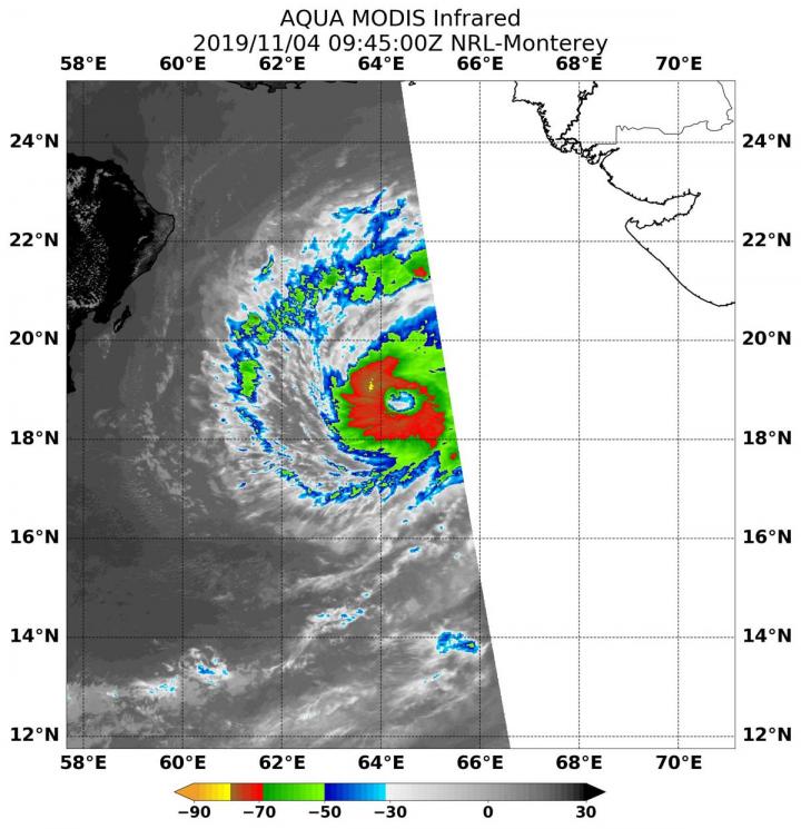
On Nov. 4 at 4:45 a.m. EDT (0945 UTC the Moderate Imaging Spectroradiometer or MODIS instrument that flies aboard NASA’s Aqua satellite used infrared light to analyze the strength of storms within the tropical cyclone. NASA researches these storms to determine how they rapidly intensify, develop and behave.
Tropical cyclones are made of up hundreds of thunderstorms, and infrared data can show where the strongest storms are located. They can do that because infrared data provides temperature information, and the strongest thunderstorms that reach highest into the atmosphere have the coldest cloud top temperatures.
MODIS found those strongest storms were circling the center of circulation where cloud top temperatures were as cold as minus 80 degrees Fahrenheit (minus 62.2 Celsius). NASA research has found that cloud top temperatures that cold indicate strong storms with the potential to generate heavy rainfall.
On Nov. 4 at 4 a.m. EDT (0900 UTC), Tropical Cyclone Maha had maximum sustained winds near 100 knots (115 mph /185 kph). It was located near 18.5 degrees north latitude and 64.4 degrees east longitude, about 405 miles south-southwest of Karachi, Pakistan. Maha was moving to the northwest.
Forecasters at the Joint Typhoon Warning Center noted that Maha will move west-northwest and continue to strengthen. The storm will then turn to the east and weaken rapidly, before making landfall in northwestern India.
###
Hurricanes are the most powerful weather event on Earth. NASA’s expertise in space and scientific exploration contributes to essential services provided to the American people by other federal agencies, such as hurricane weather forecasting.
Rob Gutro
NASA’s Goddard Space Flight Center.
Media Contact
Rob Gutro
[email protected]
Original Source
https:/


