Credit: Credit: NASA Worldview, Earth Observing System Data and Information System (EOSDIS)
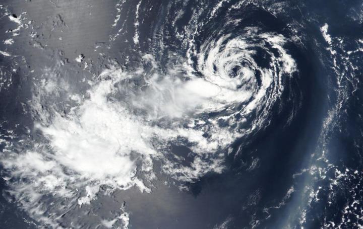
Tropical Depression 06W has been around for days, and continues to hold together as it moves in a westerly direction toward Taiwan in the Northwestern Pacific Ocean. NASA-NOAA’s Suomi NPP satellite captured a visible image of the storm.
On Aug. 12, the Visible Infrared Imaging Radiometer Suite (VIIRS) instrument aboard Suomi NPP revealed a partially exposed low-level circulation with building thunderstorms over the western quadrant of Tropical Depression 06W. Satellite imagery also showed a weakly defined, broad center. The image was created by NASA Worldview website at NASA’s Goddard Space Flight Center in Greenbelt, Md.
At 11 a.m. EDT (1500 UTC) on Aug. 12, the Joint Typhoon Warning Center (JTWC) noted Tropical Depression 06W (TD06W) was centered near latitude 5.0 degrees north and longitude 133.4 degrees east, approximately 349 nautical miles east-southeast of Kadena Air Base, Okinawa Island, Japan. 06W was moving to the west-southwest. Maximum sustained winds remained near 25 knots (29 mph/46 kph).
TD06W is expected to maintain intensity for another day and a half, when it will then weaken.
NASA Researches Tropical Cyclones
Hurricanes/tropical cyclones are the most powerful weather events on Earth. NASA’s expertise in space and scientific exploration contributes to essential services provided to the American people by other federal agencies, such as hurricane weather forecasting.
For more than five decades, NASA has used the vantage point of space to understand and explore our home planet, improve lives and safeguard our future. NASA brings together technology, science, and unique global Earth observations to provide societal benefits and strengthen our nation. Advancing knowledge of our home planet contributes directly to America’s leadership in space and scientific exploration.
###
By Rob Gutro
NASA’s Goddard Space Flight Center
Media Contact
Rob Gutro
[email protected]
Original Source
https:/


