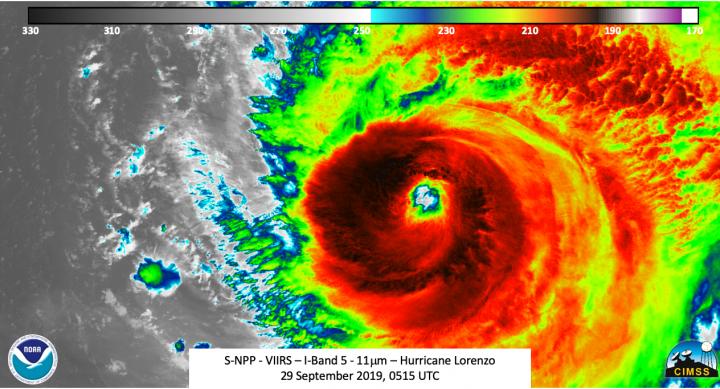
Credit: Credit: NASA/NOAA/UWM-CIMSS, William Straka
Over the weekend of Sept. 28 and 29, Hurricane Lorenzo attained Category 5 strength briefly, becoming the strongest hurricane on record in the eastern-most Atlantic Ocean. Lorenzo has also attained and contributed to some other significant statistics. NASA-NOAA’s Suomi NPP satellite provided infrared data over two days provided forecasters with changes in the storm’s eye, powerful thunderstorms and gravity waves it was creating.
Record Setting
On Saturday, Sept. 28, when Lorenzo attained Category 5 (Cat 5) strength on the Saffir-Simpson Hurricane Wind Scale it was in a place more than 600 miles east-northeast of the previous record Cat 5 storm. It also had the lowest air pressure east of 50 degrees west longitude when the pressure dropped to 925 millibars.
There have been 26 Category 5 storms since 1960. Hurricane Camille was the first and Lorenzo is the latest. Over the past 3 years, six storms attained that level of intensity. The others include Dorian, Michael, Maria, Irma and Matthew). Earlier this year Dorian reached Category 5 strength, so this year joins only six other years that contained more than one Cat 5 storm since records began. Other years with more than one Cat 5 storm include 1932, 1933, 1961, 2005, 2007 and 2017.
NASA-NOAA’s Suomi NPP Satellite Views
The Suomi NPP satellite passed over the eastern Atlantic Ocean on Sept. 29, after Lorenzo’s peak and weakening back to a Category 4 hurricane. The Visible Infrared Imaging Radiometer Suite (VIIRS) instrument aboard Suomi NPP provided infrared data on Lorenzo.
Tropical cyclones are made of up hundreds of thunderstorms, and infrared data can show where the strongest storms are located. They can do that because infrared data provides temperature information, and the strongest thunderstorms that reach highest into the atmosphere have the coldest cloud top temperatures.
“As with other strong hurricanes, the eye was well defined along with mesovorticies seen,” said William Straka III, a researcher who created some Suomi NPP images at the University of Wisconsin – Madison, Space Science and Engineering Center (SSEC), Cooperative Institute for Meteorological Satellite Studies (CIMSS). The strength of the storm also was producing mesospheric gravity waves. Straka said, “Something interesting to note is that the mesospheric gravity waves from Lorenzo could be seen up to 1,180 km (733 miles) away. This isn’t that unheard of, but still worth to note.”
Mesovortices are small-scale rotational features found in convective storms, such as found in the eyewall of tropical cyclones. They can be as big as tens of miles in diameter to a mile or less, and can be immensely intense.
NOAA defines a gravity wave as a wave created by the action of gravity on density variations in the stratified atmosphere. A generic classification for lee waves, mountains waves, and many other waves that form in the atmosphere.
At 0300Z on September 30 (11 p.m. EDT on Sept. 29), the National Hurricane Center or NHC Public advisory stated that Hurricane Lorenzo had winds of 110 mph, making it just barely a Category 3 hurricane. Three hours later at 2 a.m. EDT (0600 UTC) on Sept. 30, Lorenzo had weakened to a Category 2 hurricane as wind had decreased to 105 mph. When NASA-NOAA’s Suomi NPP satellite passed over Lorenzo, it analyzed the storm again in infrared light. NPP imagery showed mesospheric gravity waves quite possibly due to the energy being released as the storm weakened. NPP also showed a cloud-filled eye with clouds expanding to the northern quadrant. Both of these observations support the NHC Forecast Discussion at 5 a.m. EDT (0900 UTC).
Hurricane Lorenzo on Sept 30
On Sept. 30, 2019 at 8 a.m. EDT (1200 UTC), NOAA’s National Hurricane Center issued watches for the Azores Islands. The Azores is a self-governing region of Portugal. The Azores consist of nine inhabited islands. All of them are under a watch from Lorenzo. NHC posted a Hurricane Watch for Flores, Corvo, Faial, Pico, Sao Jorge, Graciosa, Terceira, and a Tropical Storm Watch is in effect for Sao Miguel, Santa Maria.
At that time, the center of Hurricane Lorenzo was located near latitude 29.4 degrees north and longitude 42.9 degrees west. Lorenzo is moving toward the north-northeast near 14 mph (20 kph). Maximum sustained winds are near 105 mph (165 kph) with higher gusts. Hurricane-force winds extend outward up to 90 miles (150 km) from the center and tropical-storm-force winds extend outward up to 255 miles (405 km). The estimated minimum central pressure is 957 millibars.
Lorenzo’s Track
On the forecast track, the center of Lorenzo is expected to pass near the western Azores early on Wednesday, Oct. 2. Some weakening is forecast over the next two day, but Lorenzo is forecast to remain a large and powerful hurricane while it passes near the Azores.
In addition to threatening the Azores, Lorenzo is having quite the impact in the North Atlantic, despite being in the Eastern North Atlantic. NHC said, “Large swells spreading across much of the northern Atlantic basin. These swells are likely to cause life-threatening surf and rip current conditions.”
Hurricanes are the most powerful weather event on Earth. NASA’s expertise in space and scientific exploration contributes to essential services provided to the American people by other federal agencies, such as hurricane weather forecasting.
###
Rob Gutro
NASA’s Goddard Space Flight Center, Greenbelt, Md.
Media Contact
Rob Gutro
[email protected]
Original Source
https:/


