Credit: NASA Worldview, Earth Observing System Data and Information System (EOSDIS)
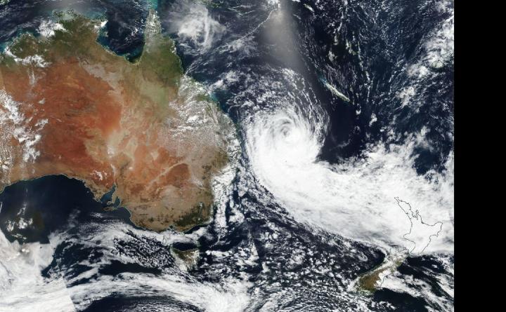
When you look at a Tropical Cyclone Oma from space, you’ll get a sense of its massive size. While orbiting the Earth, NASA-NOAA’s Suomi NPP satellite provided a look at the large tropical storm in the Southern Pacific Ocean.
Oma weakened rapidly from a typhoon to a tropical storm, and on Feb 22, the Visible Infrared Imaging Radiometer Suite (VIIRS) instrument aboard NASA-NOAA’s Suomi NPP satellite captured a visible image of Oma. The VIIRS image also showed a long the bulk of clouds and thunderstorms pushed into the storm’s southern quadrant, looking like a large tail. That’s because northeasterly winds, or northeasterly vertical wind shear is pushing the clouds and tearing the storm apart. The Joint Typhoon Warning Center noted that rain bands, bands of thunderstorms that feed into the center, are unraveling, and the storm is elongating. Whenever a storm is no longer circular and elongates, it is a sign of weakening.
At 10 a.m. EDT (1500 UTC) the Joint Typhoon Warning Center or JTWC noted that Oma’s maximum sustained winds dropped to 35 knots (40 mph). Oma’s center was located near 27.7 degrees south latitude and 159.9 east longitude, that’s approximately 367 nautical miles east of Brisbane, Australia. Oma has tracked south and is forecast to turn to the north and is expected to dissipate in a day or two.
###
By Rob Gutro
NASA’s Goddard Space Flight Center
Media Contact
Rob Gutro
[email protected]
Original Source
https:/


