Credit: Credit: NASA Worldview, Earth Observing System Data and Information System (EOSDIS)
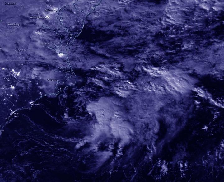
NASA-NOAA’s Suomi NPP satellite provided a nighttime view of the Atlantic Ocean hurricane season’s latest tropical cyclone off the coast of North Carolina. Ocean swells from the depression are affecting coastal North Carolina today, Sept. 1.
Tropical Depression 15 formed by 5 p.m. EDT off the coast of North Carolina and showed organized convection (rising air that forms the thunderstorms that make up a tropical cyclone). The storm has been battling vertical wind shear since its formation, which has kept it from intensifying into a tropical storm.
NASA’s Night-Time View
The Visible Infrared Imaging Radiometer Suite (VIIRS) instrument aboard Suomi NPP provided a nighttime image of 15 during the early morning hours of Sept 1 when it flew over the northwestern Atlantic Ocean. Infrared data showed the most powerful thunderstorms east of center where cloud top temperatures were as cold as or colder than minus 70 degrees Fahrenheit. Deep convection remains displaced to the east and southeast of the depression’s low-level center due to increasing west-northwesterly wind shear.
The image was created using the NASA Worldview application at NASA’s Goddard Space Flight Center, Greenbelt, Md.
TD15’s Status
At 11 a.m. EDT (1500 UTC), NOAA’s National Hurricane Center (NHC) reported the center of Tropical Depression 15 (TD 15) was located near latitude 34.7 degrees north and longitude 73.1 degrees west. TD 15 is centered about 140 miles (225 km) east-southeast of Cape Hatteras, North Carolina. The depression is moving toward the east-northeast near 14 mph (22 kph). This general motion is forecast today, followed by a turn toward the east by Thursday. On the forecast track, the center of the depression will continue to move away from the North Carolina coast today.
Maximum sustained winds remain near 35 mph (55 kph) with higher gusts. The depression could become a tropical storm later today or tonight. Gradual weakening is anticipated by late Wednesday. The system is forecast to become a remnant low on Thursday.
TD15’s Effects Along the U.S. Coast
Although the depression is off the coast of North Carolina it is generating ocean swells that are affecting the U.S. coast. NHC said, “Swells generated by the depression will continue to affect portions of the Outer Banks of North Carolina through this evening, causing life-threatening surf and rip current conditions.” There are no other watches or warnings in effect and the storm is forecast to move away from the coast.
About NASA’s EOSDIS Worldview
NASA’s Earth Observing System Data and Information System (EOSDIS) Worldview application provides the capability to interactively browse over 700 global, full-resolution satellite imagery layers and then download the underlying data. Many of the available imagery layers are updated within three hours of observation, essentially showing the entire Earth as it looks “right now.”
NASA Researches Earth from Space
For more than five decades, NASA has used the vantage point of space to understand and explore our home planet, improve lives and safeguard our future. NASA brings together technology, science, and unique global Earth observations to provide societal benefits and strengthen our nation. Advancing knowledge of our home planet contributes directly to America’s leadership in space and scientific exploration.
###
For updated forecasts, visit: http://www.
By Rob Gutro
NASA’s Goddard Space Flight Center
Media Contact
Rob Gutro
[email protected]
Original Source
https:/


