Credit: NASA Worldview, Earth Observing System Data and Information System (EOSDIS)
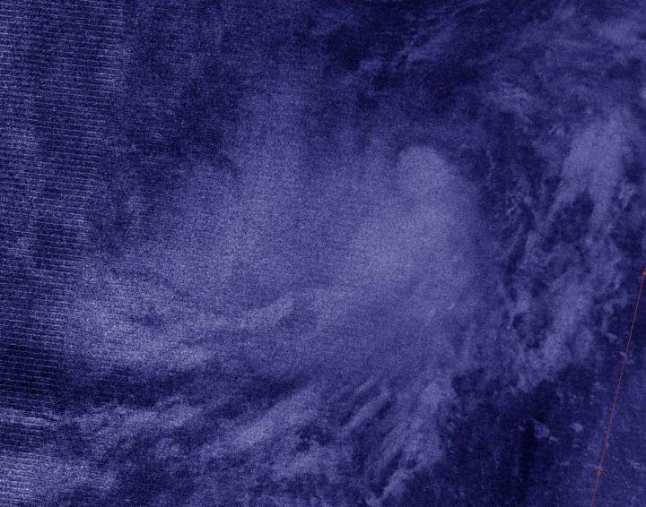
NASA-NOAA’s Suomi NPP satellite provided an infrared image of Tropical Depression 20 in that helped confirm it organized and strengthened into Tropical Storm Teddy. Teddy, which has broken a hurricane season record, is expected to become a major hurricane later in the week, according to the National Hurricane Center (NHC).
Tropical Depression 20 formed late on Saturday, Sept. 12 in the Central North Atlantic Ocean, about 2,030 miles (3,265 km) east of the Northern Leeward Islands. It maintained tropical depression status until this morning, Sept. 14, when infrared satellite data helped confirm it had strengthened and organized. NHC reported this makes Tropical Storm Teddy the earliest 19th named storm, besting the unnamed tropical storm on October 4, 2005.
NASA’s Night-Time View of Elida’s Intensification
The Visible Infrared Imaging Radiometer Suite (VIIRS) instrument aboard Suomi NPP provided a nighttime image of Tropical Depression 20. The nighttime image, taken around midnight on Sept. 14, revealed that Tropical Depression 20 had become more organized helping confirm that it had become Tropical Storm Teddy in the Central Atlantic Ocean. The image was created using the NASA Worldview application at NASA’s Goddard Space Flight Center in Greenbelt, Md.
NHC Senior Hurricane Forecaster Stacy Stewart noted, “Earlier ASCAT [scatterometer that measures wind speed] data indicated peak winds of 33 knots in the northwestern quadrant of the depression. Since then, convection has increased and so have the various satellite intensity estimates. The initial intensity is increased to 35 knots [40 mph] based on the ASCAT data, and satellite estimates of 35 knots from TAFB [NOAA’s Tropical Analysis and Forecast Branch] and 38 knots from University of Wisconsin-Madison-CIMSS SATCON.” The CIMSS Satellite Consensus (SATCON) product blends tropical cyclone intensity estimates derived from multiple objective algorithms to produce an ensemble estimate of intensity for current tropical cyclones worldwide.
Teddy’s Status on Sept. 14
At 5 a.m. EDT (0900 UTC) on Sept. 14, the center of Tropical Storm Teddy was located near latitude 13.4 degrees north and longitude 40.4 degrees west. Teddy is located about 1,405 miles (2,260 km) east of the Lesser Antilles. Teddy is moving toward the west-northwest near 14 mph (22 kph). Maximum sustained winds have increased to near 40 mph (65 kph) with higher gusts. The estimated minimum central pressure is 1004 millibars.
Teddy’s Forecast
A continued west-northwestward motion is expected for the next day or two followed by a turn toward the northwest by mid-week. Additional strengthening is anticipated, and Teddy is forecast to become a hurricane in a couple of days.
Large swells generated by Tropical Storm Teddy are expected to reach the Lesser Antilles and the northeastern coast of South America on Wednesday. These swells are likely to cause life-threatening surf and rip current conditions.
###
About NASA’s EOSDIS Worldview
NASA’s Earth Observing System Data and Information System (EOSDIS) Worldview application provides the capability to interactively browse over 700 global, full-resolution satellite imagery layers and then download the underlying data. Many of the available imagery layers are updated within three hours of observation, essentially showing the entire Earth as it looks “right now.”
NASA Researches Earth from Space
For more than five decades, NASA has used the vantage point of space to understand and explore our home planet, improve lives and safeguard our future. NASA brings together technology, science, and unique global Earth observations to provide societal benefits and strengthen our nation. Advancing knowledge of our home planet contributes directly to America’s leadership in space and scientific exploration.
For updated forecasts, visit: http://www.
By Rob Gutro
NASA’s Goddard Space Flight Center
Media Contact
Rob Gutro
[email protected]


