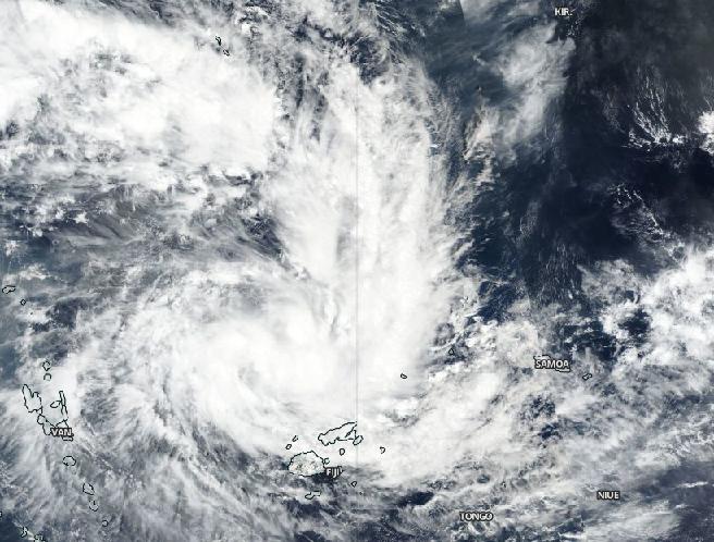
Credit: NASA Worldview, Earth Observing System Data and Information System (EOSDIS)
Imagery from NASA-NOAA’s Suomi NPP satellite showed that a tropical low-pressure area has consolidated and organized in the Southern Pacific Ocean near Fiji.
Tropical Storm Sarai has formed to the west of Fiji. Fiji is an archipelago, consisting of more than 300 islands in the South Pacific Ocean.
On Dec. 26 at 6:43 a.m. EST) Dec. 27 at 12:43 a.m. Fiji local time, the Fiji Meteorological Service has issued various warnings for Fiji and surrounding islands. A gale warning remains in force for Rotuma, Vanua Levu, Taveuni and nearby smaller islands, Yasawa and Mamanuca Group, Kadavu, Lomaiviti group, Viti Levu and nearby smaller islands. A strong wind warning remains in force for the rest of Fiji. A heavy rain warning remains in force for the Fiji group.
The Visible Infrared Imaging Radiometer Suite (VIIRS) instrument aboard Suomi NPP provided a visible image of Sarai that revealed a band of thunderstorms were wrapping into the low-level center of circulation.
At 4 a.m. EST (0900 UTC) on Dec. 26, the Joint Typhoon Warning Center or JTWC in Pearl Harbor, Hawaii noted that Sarai had maximum sustained winds near 35 knots (40 mph/65 kph). Sarai was located near latitude 13.7 degrees south and longitude 176.2 degrees east, approximately 320 nautical miles north-northwest of Suva, Fiji. The tropical cyclone has tracked south southeastward. The tropical storm’s center is expected to stay over water, just southwest of Fiji. JTWC said, “The favorable environment will allow steady ‘intensification to 65 knots as it passes Nadi.”
Tropical cyclones and hurricanes are the most powerful weather events on Earth. NASA’s expertise in space and scientific exploration contributes to essential services provided to the American people by other federal agencies, such as hurricane weather forecasting.
For updated forecasts from the Fiji Meteorological Service, visit: http://www.
###
Media Contact
Rob Gutro
[email protected]
Original Source
https:/


