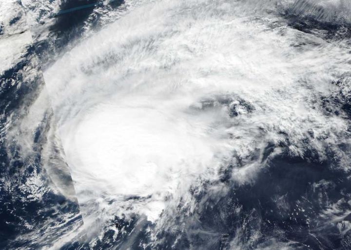
Credit: NASA Worldview, Earth Observing System Data and Information System (EOSDIS) / NOAA
Halong continued to weaken and is transitioning into an extra-tropical cyclone. NASA-NOAA’s Suomi NPP satellite provided a visible image of the less organized storm.
The Suomi NPP satellite passed over Halong in the Northwestern Pacific Ocean on Nov. 8. The Visible Infrared Imaging Radiometer Suite (VIIRS) instrument aboard Suomi NPP provided a visible image of the storm that showed it appeared elongated and had a ragged low-level circulation center.
At 10 a.m. EDT (1500 UTC) on Nov. 8, the center of Halong was located near latitude 30.0 degrees north and longitude 160.2 degrees east. Tropical storm Halong’s center was located approximately 419 nautical miles northeast of Minami Tori Shima. Halong’s maximum sustained winds had dropped to 60 knots (69 mph/111 kph). Halong was moving quickly to the east-northeast at 24 knots.
The Joint Typhoon Warning Center or JTWC said that Halong will continue to track northeastward and gradually turn east-northeastward later on Nov. 8. The JTWC noted, “The environment will become more unfavorable with increasing vertical wind shear and cooling sea surface temperatures, leading to rapid weakening. Extra-tropical transition will begin later on Nov. 8 as begins to interact with the baroclinic zone. A baroclinic zone is a region in which a temperature gradient exists on a constant pressure surface.
When a storm becomes extra-tropical it means that a tropical cyclone has lost its “tropical” characteristics. NOAA’s National Hurricane Center defines “extra-tropical” as a transition that implies both poleward displacement (meaning it moves toward the north or south pole) of the cyclone and the conversion of the cyclone’s primary energy source from the release of latent heat of condensation to baroclinic (the temperature contrast between warm and cold air masses) processes. It is important to note that cyclones can become extratropical and still retain winds of hurricane or tropical storm force.
###
Hurricanes and typhoons are the most powerful weather event on Earth. NASA’s expertise in space and scientific exploration contributes to essential services provided to the American people by other federal agencies, such as hurricane weather forecasting.
By Rob Gutro
NASA’s Goddard Space Flight Center
Media Contact
Rob Gutro
[email protected]
Original Source
https:/


