Credit: Credit: NASA Worldview, Earth Observing System Data and Information System (EOSDIS).
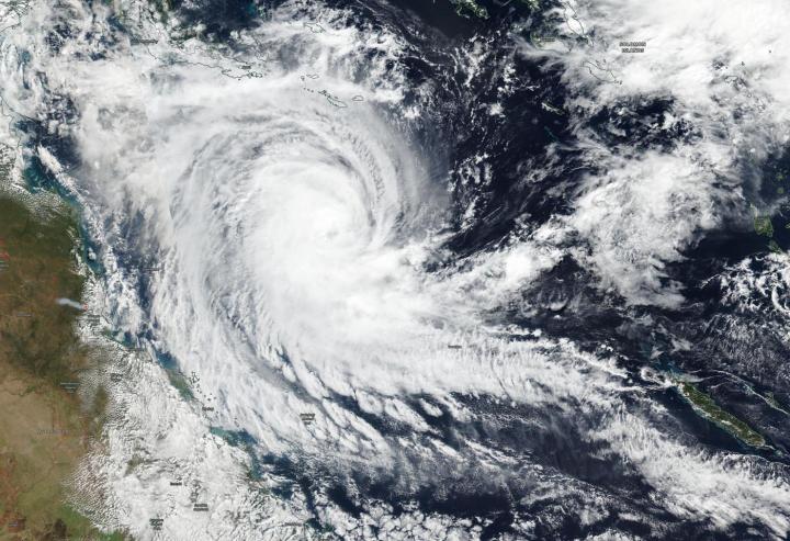
NASA-NOAA’s Suomi NPP satellite passed over the Southern Pacific Ocean and captured a visible image of Tropical Cyclone Ann in the Coral Sea, off the east coast of Queensland, Australia.
The Australian Bureau of Meteorology or ABM noted that Watch zone includes Cape York to Port Douglas, including Lockhart River, Coen, and Cooktown.
NASA-NOAA’s Suomi NPP satellite passed over Ann on May 13 and the Visible Infrared Imaging Radiometer Suite (VIIRS) instrument provided a visible image of the storm. The VIIRS image showed powerful thunderstorms wrapping around the center of circulation that appeared to be a cloud-filled eye. The VIIRS image also revealed a large thick band of thunderstorms extending from the center to the southeast, giving the appearance of a large tail.
At 8 a.m. EDT (10 p.m. AEST local time) on Monday, May 13, 2019, ABM noted that Ann is a category 1 storm, sustained winds near the center of 40 knots (46 mph/75 kilometers per hour). Ann is centered near 15.2 degrees South latitude and 151.5 degrees East longitude. That is about 398 miles (640 kilometers) east northeast of Cairns. Ann is moving to the west-northwest at 17 miles (27 kilometers) per hour.
ABM forecasts that Ann will move on a westerly track over the next couple of days and make landfall on the east coast of the Cape York Peninsula, Queensland on the morning of May 15, local time most likely as a category 1 system. Ann is forecast to make landfall near the town of Coen. Coen is located in the Shire of Cook, Queensland.
For updated forecasts, visit the ABM website: http://www.
###
Media Contact
Rob Gutro
[email protected]
Original Source
https:/


