• HOME
  • NEWS
  • EXPLORE
    • CAREER
      • Companies
      • Jobs
    • EVENTS
    • iGEM
      • News
      • Team
    • PHOTOS
    • VIDEO
    • WIKI
  • BLOG
  • COMMUNITY
    • FACEBOOK
    • INSTAGRAM
    • TWITTER
Wednesday, December 17, 2025
BIOENGINEER.ORG
No Result
View All Result
  • Login
  • HOME
  • NEWS
  • EXPLORE
    • CAREER
      • Companies
      • Jobs
        • Lecturer
        • PhD Studentship
        • Postdoc
        • Research Assistant
    • EVENTS
    • iGEM
      • News
      • Team
    • PHOTOS
    • VIDEO
    • WIKI
  • BLOG
  • COMMUNITY
    • FACEBOOK
    • INSTAGRAM
    • TWITTER
No Result
View All Result
Bioengineer.org
No Result
View All Result
Home NEWS Science News

NASA-NOAA satellite catches Hurricane Kiko at night

Bioengineer by Bioengineer
September 17, 2019
in Science News
Reading Time: 2 mins read
0
IMAGE
Share on FacebookShare on TwitterShare on LinkedinShare on RedditShare on Telegram

IMAGE

Credit: Credit: NASA/NOAA/NRL

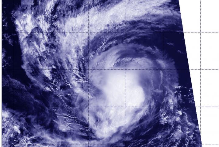
Hurricane Kiko continued to track west through the Eastern Pacific Ocean when NASA-NOAA’s Suomi NPP satellite passed overhead and provided a view of the storm. Satellite imagery revealed an elongated shape, which indicated wind shear was still affecting Kiko.

The Visible Infrared Imaging Radiometer Suite (VIIRS) instrument aboard Suomi NPP provided an infrared image of the storm on Sept. 16 at 6:12 p.m. EDT (2212 UTC). The VIIRS image and microwave satellite imagery indicates that the northeasterly wind shear that was still affecting Kiko.

In general, wind shear is a measure of how the speed and direction of winds change with altitude. Tropical cyclones are like rotating cylinders of winds. Each level needs to be stacked on top each other vertically in order for the storm to maintain strength or intensify. Wind shear occurs when winds at different levels of the atmosphere push against the rotating cylinder of winds, weakening the rotation by pushing it apart at different levels.

The National Hurricane Center noted that satellite imagery shows an irregular shaped central dense overcast with the anvil clouds being forced to the southwest of center. Anvil clouds form in the upper parts of thunderstorms and the anvils are mostly composed of ice (because they are so high in the atmosphere). They get their anvil shape because rising air in thunderstorms expands and spreads out as the air flattens against the bottom of the stratosphere.

At 5 a.m. EDT (0900 UTC) on Sept. 17, the center of Hurricane Kiko was located near latitude 17.2 degrees north and longitude 124.7 degrees west. That is about 1,035 miles (1,670 km) west-southwest of the southern tip of Baja California, Mexico. Kiko is moving toward the west near 5 mph (7 km/h). A turn to the west-southwest is expected today, followed by a turn to the west to west-northwest by Wednesday.

Maximum sustained winds are near 80 mph (130 kph) with higher gusts. Hurricane-force winds extend outward up to 15 miles (30 km) from the center and tropical-storm-force winds extend outward up to 60 miles (95 km). The estimated minimum central pressure is 985 millibars.

The National Hurricane Center said, “Additional weakening is expected through this evening and Kiko is forecast to become a tropical storm later today. Some slight re-strengthening is possible Wednesday and Thursday.”

For updated forecasts. visit: http://www.nhc.noaa.gov

###

Media Contact
Rob Gutro
[email protected]

Original Source

https://blogs.nasa.gov/hurricanes/2019/09/17/kiko-eastern-pacific-ocean-3/

Tags: Atmospheric ChemistryAtmospheric ScienceClimate ChangeClimate ScienceEarth ScienceMeteorologyTechnology/Engineering/Computer ScienceTemperature-Dependent PhenomenaWeather/Storms
Share13Tweet8Share2ShareShareShare2

Related Posts

Revolutionary rGO/CeFe2O4 Nanohybrid: Multi-Functional Applications Explored

Revolutionary rGO/CeFe2O4 Nanohybrid: Multi-Functional Applications Explored

December 17, 2025

Enhanced Leuprolide Acetate Delivery via SNEDDS Technology

December 17, 2025

AI-Driven SPOT Imaging Enhances Myocardial Scar Detection

December 17, 2025

Programmable 200 GOPS Photonic Ising Machine

December 17, 2025
Please login to join discussion

POPULAR NEWS

  • Nurses’ Views on Online Learning: Effects on Performance

    Nurses’ Views on Online Learning: Effects on Performance

    70 shares
    Share 28 Tweet 18
  • NSF funds machine-learning research at UNO and UNL to study energy requirements of walking in older adults

    70 shares
    Share 28 Tweet 18
  • MoCK2 Kinase Shapes Mitochondrial Dynamics in Rice Fungal Pathogen

    72 shares
    Share 29 Tweet 18
  • Unraveling Levofloxacin’s Impact on Brain Function

    52 shares
    Share 21 Tweet 13

About

We bring you the latest biotechnology news from best research centers and universities around the world. Check our website.

Follow us

Recent News

Revolutionary rGO/CeFe2O4 Nanohybrid: Multi-Functional Applications Explored

Enhanced Leuprolide Acetate Delivery via SNEDDS Technology

AI-Driven SPOT Imaging Enhances Myocardial Scar Detection

Subscribe to Blog via Email

Enter your email address to subscribe to this blog and receive notifications of new posts by email.

Join 70 other subscribers
  • Contact Us

Bioengineer.org © Copyright 2023 All Rights Reserved.

Welcome Back!

Login to your account below

Forgotten Password?

Retrieve your password

Please enter your username or email address to reset your password.

Log In
No Result
View All Result
  • Homepages
    • Home Page 1
    • Home Page 2
  • News
  • National
  • Business
  • Health
  • Lifestyle
  • Science

Bioengineer.org © Copyright 2023 All Rights Reserved.