Credit: NASA/NOAA/NRL
NASA-NOAA’s Suomi NPP satellite passed over the Gulf of Mexico and revealed that a low pressure area was developing into a depression. On Oct. 25, that low pressure area became Tropical Depression 17.
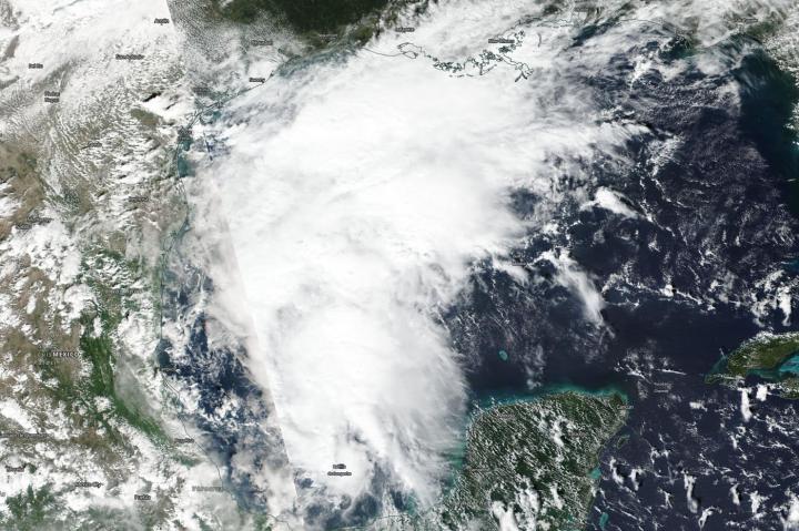
On Oct. 24, the Visible Infrared Imaging Radiometer Suite (VIIRS) instrument aboard NASA-NOAA’s Suomi NPP satellite captured a visible image of the structure of the low pressure area that became Tropical Depression 17 on Oct. 25. The storm appeared elongated from south to north, but the center was actually located west of all of the clouds and showers. In satellite imagery on Oct. 25, the National Hurricane Center said, “Satellite imagery indicates that the low pressure system in the western Gulf of Mexico has developed a well-defined circulation. In addition, a cluster of strong convection is located near and to the northeast of the low-level center.”
Status of Tropical Depression 17
At 11 a.m. EDT (1500 UTC) on Oct. 25, the center of Tropical Depression 17 was located near latitude 25.6 degrees north and longitude 94.4 degrees west. That puts the center about 320 miles (515 km) south-southwest of Lake Charles, Louisiana.
The depression was moving toward the north near 16 mph (26 kph). A motion toward the north-northeast at a faster forward speed is expected later in the day and through Sunday [Oct 27]. Maximum sustained winds are near 35 mph (55 kph) with higher gusts. The estimated minimum central pressure is 1006 millibars.
The National Hurricane Center or NHC said, “Some strengthening is expected and the depression could become a tropical storm later in the day on Oct. 25. The cyclone is then expected to merge with a cold front and become a post-tropical low with gale-force winds tonight before the center reaches the Gulf coast.”
On the forecast track, the center of the cyclone should move across the northwestern Gulf of Mexico this afternoon and then move over the northern Gulf coast tonight or Saturday morning.
NHC Forecasts Conditions Expected
The NHC noted the following conditions are forecast: Gale-force winds associated with this system should spread over portions of the northern Gulf coast tonight and Saturday morning. The depression and rainfall ahead of the system along and north of the frontal boundary across the Central Gulf coast is expected to produce total rainfall accumulations of 2 to 4 inches with maximum totals of 8 inches across the Central Gulf coast into the Lower Mississippi Valley through Saturday morning. These rains may produce flash flooding across the Central Gulf coast into the Lower Mississippi Valley.
Above-normal tides and associated coastal flooding are possible across portions of the northern Gulf coast. A couple tornadoes are possible through tonight across southeast portions of Louisiana and Mississippi into southwest Alabama.
Forecasting a Merge With a Cold Front
The NHC noted, “Since the depression is expected to merge with a cold front and become post-tropical by tonight, hazards related to wind, rainfall and coastal flooding will be covered by products issued by local National Weather Service forecast offices, available at weather.gov.”
###
Hurricanes are the most powerful weather event on Earth. NASA’s expertise in space and scientific exploration contributes to essential services provided to the American people by other federal agencies, such as hurricane weather forecasting.
By Rob Gutro
NASA’s Goddard Space Flight Center
Media Contact
Rob Gutro
[email protected]
Original Source
https:/


