Credit: NASA/JAXA/NRL
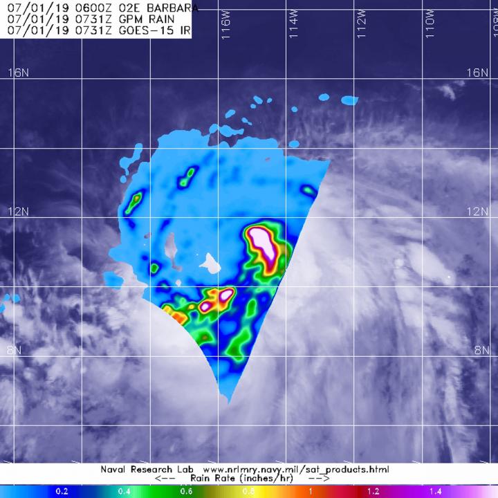
Tropical Storm Barbara formed on Sunday, June 30 in the Eastern Pacific Ocean over 800 miles from the coast of western Mexico. The Global Precipitation Measurement mission or GPM core satellite passed over the storm and measured the rate in which rain was falling throughout it.
Barbara formed as a tropical storm around 11 a.m. EDT (1500) on June 30, and slowly intensified.
The GPM core satellite passed over Tropical Storm Barbara at 3:31 a.m. EDT (0731 UTC) on July 1, 2019. GPM found the heaviest rainfall rates were occurring northeast of the center of circulation. There, rain was falling at a rate of 41 mm (about 1.6 inches) per hour. The rainfall in that area are part of a band of thunderstorms wrapping into the low-level center, and there were a couple of other areas in that same band with the same rainfall rate. GPM is a joint mission between NASA and the Japan Aerospace Exploration Agency, JAXA.
NOAA’s National Hurricane Center noted at 5 a.m. EDT (0900 UTC) on July 1, the center of Tropical Storm Barbara was located near latitude 11.2 degrees north, longitude 115.8 degrees west. That’s about 895 miles (1,445 km) south-southwest of the southern tip of Baja California, Mexico. Barbara is moving toward the west near 21 mph (33 kph). A westward to west-northwestward motion at a slower forward speed is expected over the next few days. The estimated minimum central pressure is 998 millibars (29.47 inches). Maximum sustained winds have increased to near 65 mph (100 kph) with higher gusts.
Additional strengthening is forecast during the next couple of days, and Barbara is expected to become a hurricane later today.
For forecast updates on Barbara, visit: http://www.
###
Media Contact
Rob Gutro
[email protected]
Original Source
https:/


