Credit: NASA/NRL
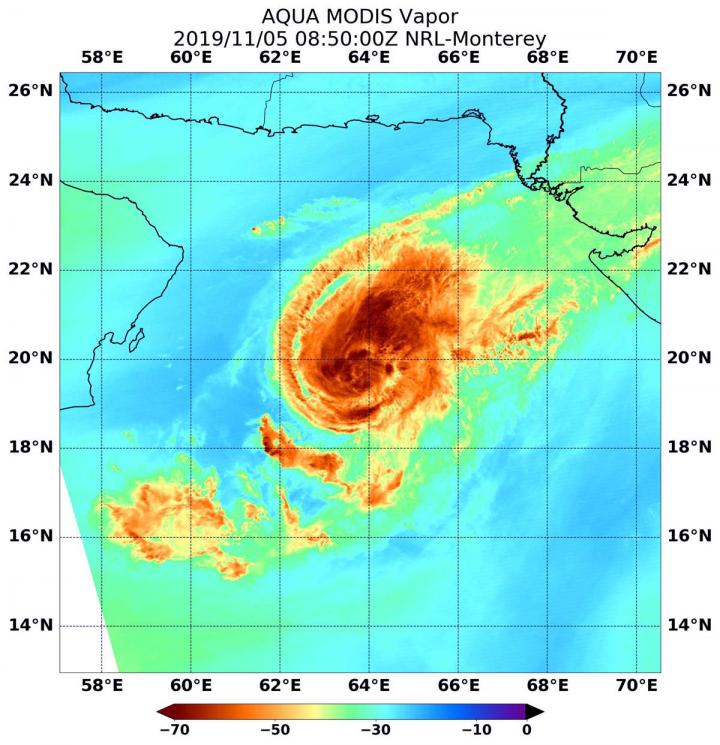
When NASA’s Aqua satellite passed over the Northern Indian Ocean, water vapor data provided information about the intensity of Tropical Cyclone Maha.
NASA’s Aqua satellite passed Tropical Cyclone Maha on Nov. 5 at 3:47 a.m. EST (0847 UTC) the Moderate Resolution Imaging Spectroradiometer or MODIS instrument gathered water vapor content and temperature information. The MODIS image showed highest concentrations of water vapor and coldest cloud top temperatures were in a fragmented band of thunderstorms around the low-level center of circulation as well as northeast of the center.
MODIS data also showed the coldest cloud top temperatures were as cold as or colder than minus 70 degrees Fahrenheit (minus 56.6 degrees Celsius) in those storms. Storms with cloud top temperatures that cold have the capability to produce heavy rainfall.
Water vapor analysis of tropical cyclones tells forecasters how much potential a storm has to develop. Water vapor releases latent heat as it condenses into liquid. That liquid becomes clouds and thunderstorms that make up a tropical cyclone. Temperature is important when trying to understand how strong storms can be. The higher the cloud tops, the colder and the stronger they are.
Around the same time as the MODIS water vapor imagery, the Atmospheric Infrared Sounder instrument aboard NASA’s Aqua satellite provided temperature data on the cloud tops. AIRS confirmed that the coldest cloud top temperatures were as cold as or colder than minus 70 degrees Fahrenheit (minus 56.6 degrees Celsius).
At 10 a.m. EDT (1500 UTC), the center of Tropical Cyclone Maha was located near latitude 19.8 degrees north and longitude 63.8 degrees east. That puts the center just 49 miles south-southwest of Karachi, Pakistan. Maha is moving to the east-northeast and has maximum sustained winds near 85 knots (98 mph/157 kph).
The Joint Typhoon Warning Center said that Maha has turned around and is now weakening, and is expected to dissipate before making landfall in northwestern India.
NASA’s Aqua satellite is one in a fleet of NASA satellites that provide data for hurricane research.
###
Hurricanes are the most powerful weather event on Earth. NASA’s expertise in space and scientific exploration contributes to essential services provided to the American people by other federal agencies, such as hurricane weather forecasting.
By Rob Gutro
NASA’s Goddard Space Flight Center
Media Contact
Rob Gutro
[email protected]
Original Source
https:/


