Credit: NASA JPL/Heidar Thrastarson
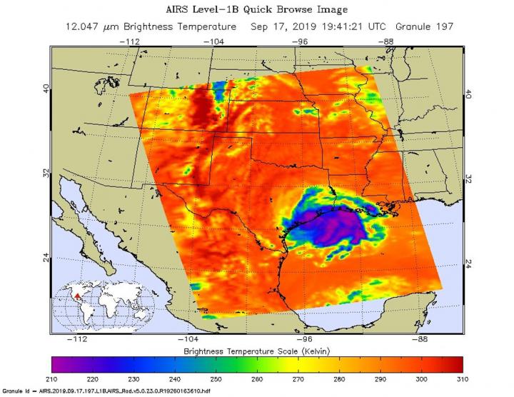
One of the ways NASA researches tropical cyclones is using infrared data that provides temperature information. The AIRS instrument aboard NASA’s Aqua satellite captured a look at those temperatures in Tropical Depression Imelda and gave insight into the storm’s rainfall potential over eastern Texas.
Cloud top temperatures provide information to forecasters about where the strongest storms are located within a tropical cyclone. Tropical cyclones do not always have uniform strength, and some sides have stronger sides than others. The stronger the storms, the higher they extend into the troposphere, and they have the colder cloud temperatures.
NASA provides data to forecasters at NOAA’s National Hurricane Center or NHC so they can incorporate in their forecasting.
On Sept. 17 at 3:41 p.m. EDT (1541 UTC) NASA’s Aqua satellite analyzed the storm using the Atmospheric Infrared Sounder or AIRS instrument. AIRS found coldest cloud top temperatures as cold as or colder than minus 63 degrees Fahrenheit (minus 53 degrees Celsius) north and east of Imelda’s center. NASA research has shown that cloud top temperatures that cold indicate strong storms that have the capability to create heavy rain. Some of the heaviest rain at the time of the image was over the Texas coastline.
Forecasters incorporated the insight into rainfall potential into their forecasts. On Sept. 18, as Imelda moved slowly to the north, heavy rains and significant flash flooding were spreading inland over eastern Texas and are expected during the next couple of days.
NOAA’s National Weather Service (NWS) Weather Prediction Center (WPC) in College Park, Md. posted, “Flash flood watches were in effect for southeast Texas and extreme southwest Louisiana.”
That heavy rainfall potential is in the forecast from the NWS WPC: Imelda is expected to produce the following rainfall amounts through Friday [Sept. 20]: Across the Upper Texas Coast into eastern Texas, including the Houston and Galveston areas…additional 5 to 10 inches. Isolated storm totals of 20 to 25 inches. Across portions of southwest Louisiana…4 to 8 inches with isolated totals of 10 inches. These rainfall totals may produce significant to life threatening flash floods.
At 11 a.m. EDT (1500 UTC), NWS said the center of Tropical Depression Imelda was located near latitude 30.6 degrees north and longitude 95.6 degrees west. The depression is moving toward the north near 5 mph (7 km/h) and this motion is expected to continue through tonight. Maximum sustained winds are near 30 mph (45 kph) with higher gusts. Little change in strength is forecast during the next 48 hours. The estimated minimum central pressure is 1009 millibars.
Hurricanes are the most powerful weather event on Earth. NASA’s expertise in space and scientific exploration contributes to essential services provided to the American people by other federal agencies, such as hurricane weather forecasting.
The AIRS instrument is one of six instruments flying on board NASA’s Aqua satellite, launched on May 4, 2002.
For updated forecasts, visit: http://www.
For updated NWS rainfall potential maps, visit: https:/
###
Media Contact
Rob Gutro
[email protected]
Original Source
https:/


