• HOME
  • NEWS
  • EXPLORE
    • CAREER
      • Companies
      • Jobs
    • EVENTS
    • iGEM
      • News
      • Team
    • PHOTOS
    • VIDEO
    • WIKI
  • BLOG
  • COMMUNITY
    • FACEBOOK
    • INSTAGRAM
    • TWITTER
Saturday, August 2, 2025
BIOENGINEER.ORG
No Result
View All Result
  • Login
  • HOME
  • NEWS
  • EXPLORE
    • CAREER
      • Companies
      • Jobs
        • Lecturer
        • PhD Studentship
        • Postdoc
        • Research Assistant
    • EVENTS
    • iGEM
      • News
      • Team
    • PHOTOS
    • VIDEO
    • WIKI
  • BLOG
  • COMMUNITY
    • FACEBOOK
    • INSTAGRAM
    • TWITTER
No Result
View All Result
Bioengineer.org
No Result
View All Result
Home NEWS Science News

NASA infrared data confirms depression became Tropical Storm Elida

Bioengineer by Bioengineer
August 10, 2020
in Science News
Reading Time: 2 mins read
0
Share on FacebookShare on TwitterShare on LinkedinShare on RedditShare on Telegram

IMAGE

Credit: Credit: NASA/NRL

After Tropical Depression 09E formed near the coast of southwestern Mexico, infrared data from NASA’s Aqua satellite helped confirm its transition to a tropical storm.

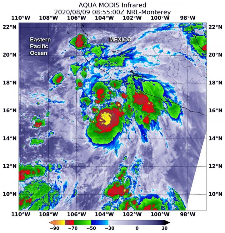
On Aug. 9 at 11 p.m. EDT (Aug. 10 at 0300 UTC), Tropical Depression 09E formed near latitude 14.7 degrees north and longitude 102.6 degrees west, about 315 miles (510 km) south-southeast of Manzanillo, Mexico. By 5 a.m. EDT (0900 UTC), infrared imagery helped confirm that 09E strengthened into a tropical storm and was renamed Elida.

The infrared imagery gathered on Aug. 9 at 4:55 a.m. EDT (0855 UTC) that helped make that confirmation included data from the Moderate Resolution Imaging Spectroradiometer or MODIS instrument. MODIS flies aboard NASA’s Aqua satellite. MODIS gathered temperature information about Elida’s cloud tops. Infrared data provides temperature information, and the strongest thunderstorms that reach high into the atmosphere have the coldest cloud top temperatures.

MODIS found the most powerful thunderstorms were around the center of circulation, where temperatures were as cold as or colder than minus 80 degrees Fahrenheit (minus 62.2 Celsius). That area was surrounded by thunderstorms slightly less high in the atmosphere, but still powerful rainmakers with cloud top temperatures as cold as or colder than minus 70 degrees Fahrenheit (minus 56.6 Celsius). Cloud top temperatures that cold indicate strong storms with the potential to generate heavy rainfall.

At 5 a.m. EDT (0900 UTC) on Aug. 10, the National Hurricane Center (NHC) said the center of Tropical Storm Elida was located near latitude 18.3 degrees north and longitude 108.8 degrees west. That is about 145 miles (235 km) east-southeast of Socorro Island, Mexico. Elida is moving toward the west-northwest near 15 mph (24 kph), and this general motion is expected to continue through Wednesday. The estimated minimum central pressure is 995 millibars.

Maximum sustained winds are near 65 mph (100 kph) with higher gusts. Tropical-storm-force winds extend outward up to 60 miles (95 km) from the center. Strengthening is forecast during the next day or two, and Elida is expected to become a hurricane later today.

NHC cautioned, “Swells generated by Elida are expected to affect portions of the coast of west-central Mexico and the southern Baja California peninsula during the next couple of days. These swells are likely to cause life-threatening surf and rip current conditions.”

Tropical cyclones/hurricanes are the most powerful weather events on Earth. NASA’s expertise in space and scientific exploration contributes to essential services provided to the American people by other federal agencies, such as hurricane weather forecasting.

For updated forecasts, visit: www.nhc.noaa.gov

###

Media Contact
Rob Gutro
[email protected]

Original Source

https://blogs.nasa.gov/hurricanes/2020/08/10/elida-eastern-pacific-ocean/

Tags: Atmospheric ChemistryAtmospheric ScienceClimate ChangeClimate ScienceEarth ScienceMeteorologyTechnology/Engineering/Computer ScienceTemperature-Dependent PhenomenaWeather/Storms
Share12Tweet8Share2ShareShareShare2

Related Posts

blank

Serum Markers Predict Atrial Fibrillation in Diabetes

August 2, 2025
blank

Intrapleural Anti-VEGF Boosts Nab-Paclitaxel Efficacy

August 2, 2025

Amyloid Fibrils Connect CHCHD10, CHCHD2 to Neurodegeneration

August 2, 2025

Mapping the Human Hippocampus: Single-Nucleus to Spatial Transcriptomics

August 2, 2025
Please login to join discussion

POPULAR NEWS

  • Blind to the Burn

    Overlooked Dangers: Debunking Common Myths About Skin Cancer Risk in the U.S.

    60 shares
    Share 24 Tweet 15
  • Neuropsychiatric Risks Linked to COVID-19 Revealed

    45 shares
    Share 18 Tweet 11
  • Dr. Miriam Merad Honored with French Knighthood for Groundbreaking Contributions to Science and Medicine

    46 shares
    Share 18 Tweet 12
  • Study Reveals Beta-HPV Directly Causes Skin Cancer in Immunocompromised Individuals

    38 shares
    Share 15 Tweet 10

About

We bring you the latest biotechnology news from best research centers and universities around the world. Check our website.

Follow us

Recent News

Serum Markers Predict Atrial Fibrillation in Diabetes

Intrapleural Anti-VEGF Boosts Nab-Paclitaxel Efficacy

Amyloid Fibrils Connect CHCHD10, CHCHD2 to Neurodegeneration

  • Contact Us

Bioengineer.org © Copyright 2023 All Rights Reserved.

Welcome Back!

Login to your account below

Forgotten Password?

Retrieve your password

Please enter your username or email address to reset your password.

Log In
No Result
View All Result
  • Homepages
    • Home Page 1
    • Home Page 2
  • News
  • National
  • Business
  • Health
  • Lifestyle
  • Science

Bioengineer.org © Copyright 2023 All Rights Reserved.