Credit: Credit: NASA JPL/Heidar Thrastarson
Satellite data of Tropical Cyclone Claudia’s cloud top temperatures revealed that the storm was weakening.
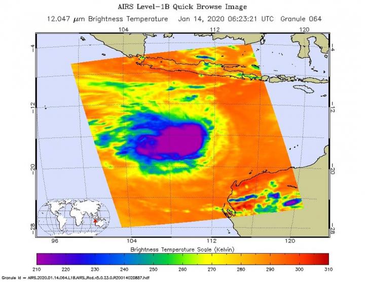
One of the ways NASA researches tropical cyclones is using infrared data that provides temperature information. The AIRS instrument aboard NASA’s Aqua satellite captured a look at those temperatures in Claudia’s cloud tops and got insight into the storm’s strength.
Cloud top temperatures provide information to forecasters about where the strongest storms are located within a tropical cyclone. Tropical cyclones do not always have uniform strength, and some sides have stronger sides than others. The stronger the storms, the higher they extend into the troposphere, and the colder the cloud temperatures.
On Jan. 14 at 1:23 EST (0623 UTC) NASA’s Aqua satellite analyzed the storm using the Atmospheric Infrared Sounder or AIRS instrument. AIRS found the coldest cloud top temperatures were getting warmer. That is an indication that the uplift of air in the storm is not as strong as it was before. AIRS found temperatures as cold as or colder than minus 63 degrees Fahrenheit (minus 53 degrees Celsius) around Claudia’s center. NASA research has shown that cloud top temperatures that cold indicate strong storms that have the capability to create heavy rain.
On Jan. 15, satellite imagery showed strongest storms within Claudia were separated well to the west of the low level center, indicating wind shear from the east was tearing the storm apart. The Joint Typhoon Warning Center noted, “Central convection has begun to unravel and elongate as convective tops warmed.” Claudia is expected to weaken further as it moves over cooler waters.
At 7:55 a.m. EST (8:55 p.m. AWST) on Jan. 15, the Australia Bureau of Meteorology noted that Claudia has maximum sustained winds near 40 mph (65 kph) and weakening. It was located near latitude 20.7 degrees south and longitude 105.8 degrees east.
Tropical Cyclone Claudia continues to move towards the southwest, well away from the Western Australia coast. It is expected to become a depression by Jan. 16 and weaken to a remnant low-pressure area.
Typhoons and hurricanes are the most powerful weather event on Earth. NASA’s expertise in space and scientific exploration contributes to essential services provided to the American people by other federal agencies, such as hurricane weather forecasting.
The AIRS instrument is one of six instruments flying on board NASA’s Aqua satellite, launched on May 4, 2002.
###
Media Contact
Rob Gutro
[email protected]
Original Source
https:/


