Credit: Credit: NASA/NRL
Tropical cyclones can become post-tropical before they dissipate, meaning they can become sub-tropical, extra-tropical or a remnant low-pressure area. As Hurricane Paulette transitioned into an extra-tropical storm, NASA’s Terra satellite provided a visible image of the powerful storm, and the National Hurricane Center issued their final advisory on the system.
What is a Post-tropical Storm?
A Post-Tropical Storm is a generic term for a former tropical cyclone that no longer possesses sufficient tropical characteristics to be considered a tropical cyclone. Former tropical cyclones that have become fully extratropical, subtropical, or remnant lows–all three classes of post-tropical cyclones. In any case, they no longer possesses sufficient tropical characteristics to be considered a tropical cyclone. However, post-tropical cyclones can continue carrying heavy rains and high winds.
What is an Extra-tropical Storm?
Often, a tropical cyclone will transform into an extra-tropical cyclone as it recurves toward the poles (north or south, depending on the hemisphere the storm is located in). An extra-tropical cyclone is a storm system that primarily gets its energy from the horizontal temperature contrasts that exist in the atmosphere.
Tropical cyclones have their strongest winds near the earth’s surface, while extra-tropical cyclones have their strongest winds near the tropopause – about 8 miles (12 km) up. Tropical cyclones, in contrast, typically have little to no temperature differences across the storm at the surface and their winds are derived from the release of energy due to cloud/rain formation from the warm moist air of the tropics.
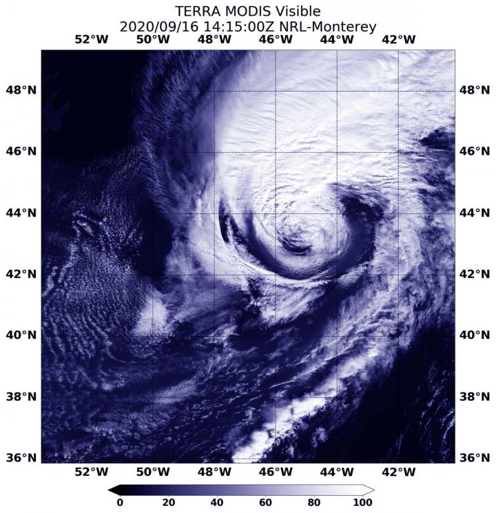
Visible NASA Imagery Shows the Transition
Visible imagery from NASA’s Terra satellite revealed Paulette’s extra-tropical transition.
On Sept. 16 at 10:16 a.m. EDT (1416), the Moderate Resolution Imaging Spectroradiometer or MODIS instrument aboard NASA’s Terra satellite provided a visible image of the storm. The MODIS image showed Paulette had a closed surface wind circulation about a well-defined center, but the storm has become asymmetric with the bulk of the clouds north of the center.
U.S. Navy Hurricane Specialist Dave Roberts at NOAA’s National Hurricane Center (NHC) in Miami, Fla. noted, “Conventional GOES-16 [satellite] visible and enhanced BD-curve satellite imagery show that Paulette has merged with the large baroclinic zone extending over the north-central Atlantic. Deep convection just to the north of the surface center that was noted on earlier microwave images has dissipated. Therefore, the system is now classified as extratropical cyclone and this is the last NHC advisory.”
According to NOAA, a Baroclinic Zone is a region in which a temperature gradient exists on a constant pressure surface. Baroclinic zones are favored areas for strengthening and weakening systems; barotropic systems, on the other hand, do not exhibit significant changes in intensity. Also, wind shear is characteristic of a baroclinic zone.
Paulette’s Final Advisory
At 11 a.m. EDT (1500 UTC), the center of Post-Tropical Cyclone Paulette was located near latitude 43.3 degrees north and longitude 45.2 degrees west. That is about 450 miles (725 km) east-southeast of Cape Race Newfoundland, Canada. The post-tropical cyclone is moving toward the east-northeast near 35 mph (56 kph), and this general motion is expected through Thursday. Maximum sustained winds have decreased to near 85 mph (140 kph) with higher gusts. The estimated minimum central pressure is 973 millibars.
Paulette’s Final Forecast
Further weakening is forecast during the next couple of days. The cyclone is forecast to slow down and turn toward the southeast and south late Thursday and Friday.
Meanwhile, ocean swells generated by Paulette will continue to affect Atlantic Canada, Bermuda, the Bahamas, and portions of the east coast of the United States through tonight. These swells are likely to cause life-threatening surf and rip current conditions.
NASA Researches Earth from Space
For more than five decades, NASA has used the vantage point of space to understand and explore our home planet, improve lives and safeguard our future. NASA brings together technology, science, and unique global Earth observations to provide societal benefits and strengthen our nation. Advancing knowledge of our home planet contributes directly to America’s leadership in space and scientific exploration.
###
For updated forecasts, visit: http://www.
By Rob Gutro
NASA’s Goddard Space Flight Center
Media Contact
Rob Gutro
[email protected]
Original Source
https:/


