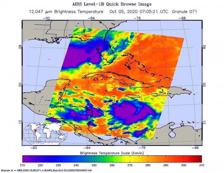
Credit: NASA JPL/Heidar Thrastarson
NASA’s Aqua satellite analyzed Tropical Storm Delta in infrared imagery as it moved through the Caribbean Sea. The imagery provided cloud top temperatures to identify the strongest areas within the storm.
Potential Tropical Cyclone 26 formed in the Caribbean Sea on Sunday, Oct. 4 by 5 p.m. EDT. Six hours later, the National Hurricane Center (NHC) classified it as Tropical Depression 26. By 8 a.m. EDT, satellite imagery helped confirm that the depression had strengthened into a tropical storm. At that time, it was given the name Delta.
Analyzing Delta’s Temperatures and Strength
One of the ways NASA researches tropical cyclones is using infrared data that provides temperature information. The AIRS instrument aboard NASA’s Aqua satellite captured a look at those temperatures in Delta and gave insight into the size of the storm and its rainfall potential.
Tropical cyclones do not always have uniform strength, and some sides have stronger sides than others. The stronger the storms, the higher they extend into the troposphere, and the colder the cloud top temperatures. NASA provides that data to forecasters at NOAA’s National Hurricane Center or NHC so they can incorporate in their forecasting.
On Oct. 5 at 3:05 a.m. EDT (0705 UTC) NASA’s Aqua satellite analyzed Tropical Storm Delta using the Atmospheric Infrared Sounder or AIRS instrument. AIRS found coldest cloud top temperatures as cold as or colder than (purple) minus 63 degrees Fahrenheit (minus 53 degrees Celsius) around the center of circulation. NASA research has shown that cloud top temperatures that cold indicate strong storms that have the capability to create heavy rain.
When meteorologists studied satellite imagery, including infrared imagery, it was noted that deep convection (rising air that forms the thunderstorms that make up a tropical cyclone) had been steadily improving in both vertical depth and structure of the storm since 2 a.m. EDT. Even the cloud pattern was becoming more circular with upper-level outflow of air at the top of the storm now having become established in all quadrants. That is an indication of improvement in a storm’s structure.
NHC noted, “However, there are still some indications in satellite imagery that the low-level and the mid-upper-level circulations are not yet vertically aligned, with the low-level center still located just inside the northern edge of the convective cloud shield.”
Eight hours after the AIRS image, the convective structure of Delta continued to improve. Earlier microwave data and early-light visible satellite imagery showed that the center of the tropical cyclone re-formed farther south within the area of deep convection.
Warnings and Watches on Oct. 5
NOAA’s National Hurricane Center has issued a number of watches and warnings for Delta on Oct. 5. A Hurricane Warning is in effect for Cuba’s province of Pinar del Rio. A Tropical Storm Warning is in effect for the Cayman Islands including Little Cayman and Cayman Brac, and for the Isle of Youth.
A Hurricane Watch is in effect for the Cuban province of Artemisa and for the Isle of Youth. A Tropical Storm Watch is in effect for the Cuban province of La Habana.
Delta’s Status
At 11 a.m. EDT (1500 UTC) on Oct. 5, the center of Tropical Storm Delta was located near latitude 16.4 degrees north and longitude 78.6 degrees west. Delta is centered about 135 miles (215 km) south of Negril, Jamaica and about 265 miles (425 km) southeast of Grand Cayman.
Delta is moving toward the west near 7 mph (11 kph), and a turn toward the west-northwest is forecast later today. A faster northwestward motion is expected on Tuesday (Oct. 6) and Wednesday (Oct. 7). Maximum sustained winds have increased to near 45 mph (75 kph) with higher gusts. The estimated minimum central pressure is 1002 millibars.
Delta’s Forecast
NHC expects additional strengthening during the next few days, and Delta is expected to become a hurricane on Tuesday before it nears western Cuba. On the forecast track, the center of Delta is expected to move away from Jamaica later today, move near or over the Cayman Islands early Tuesday, and approach western Cuba Tuesday afternoon or evening. Delta is forecast to move into the southeastern Gulf of Mexico Tuesday night, and be over the south-central Gulf of Mexico on Wednesday.
###
About NASA’s AIRS Instrument
The AIRS instrument is one of six instruments flying on board NASA’s Aqua satellite, launched on May 4, 2002.
AIRS, in conjunction with the Advanced Microwave Sounding Unit (AMSU), senses emitted infrared and microwave radiation from Earth to provide a three-dimensional look at Earth’s weather and climate. Working in tandem, the two instruments make simultaneous observations down to Earth’s surface. With more than 2,000 channels sensing different regions of the atmosphere, the system creates a global, three-dimensional map of atmospheric temperature and humidity, cloud amounts and heights, greenhouse gas concentrations and many other atmospheric phenomena. Launched into Earth orbit in 2002, the AIRS and AMSU instruments fly aboard NASA’s Aqua spacecraft. They are managed by NASA’s Jet Propulsion Laboratory (JPL) in Southern California, under contract to NASA. JPL is a division of Caltech.
NASA Research
For more than five decades, NASA has used the vantage point of space to understand and explore our home planet, improve lives and safeguard our future. NASA brings together technology, science, and unique global Earth observations to provide societal benefits and strengthen our nation. Advancing knowledge of our home planet contributes directly to America’s leadership in space and scientific exploration.
For updated forecasts, visit: http://www.
More information about AIRS can be found at: https:/
By Rob Gutro
NASA’s Goddard Space Flight Center
Media Contact
Rob Gutro
[email protected]
Original Source
https:/


