Credit: Credit: NASA/NRL
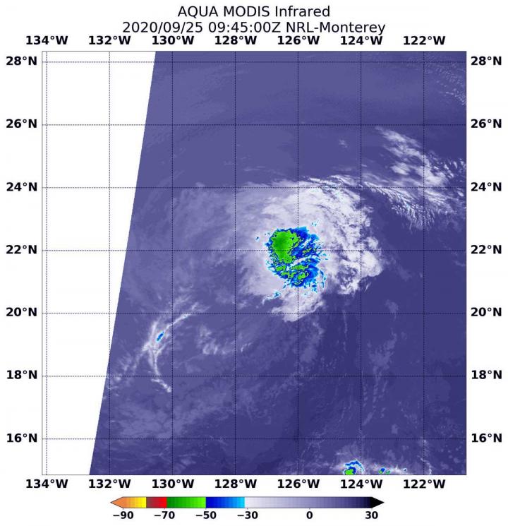
NASA’s Aqua satellite provided an infrared view of Tropical Storm Lowell that revealed the effects of outside winds battering the storm.
Wind shear occurs when winds at different levels of the atmosphere push against the rotating cylinder of winds, weakening the rotation by pushing it apart at different levels.
NASA’s Aqua Satellite Reveals Effects of Wind Shear
Infrared light is a tool used to analyze the strength of storms in tropical cyclones by providing temperature information about a system’s clouds. The strongest thunderstorms that reach highest into the atmosphere have the coldest cloud top temperatures. This temperature information can also tell forecasters if the strongest storms in a tropical cyclone are pushed away from the center, indicating wind shear.
On Sept. 25 at 5:45 a.m. EDT (0945 UTC), the Moderate Resolution Imaging Spectroradiometer or MODIS instrument that flies aboard NASA’s Aqua satellite gathered infrared data on Lowell that confirmed wind shear was adversely affecting the storm. Westerly vertical wind shear pushed strongest storms east of the center where cloud top temperatures are as cold as minus 50 degrees Fahrenheit (minus 45.5 Celsius). That small area of strongest storms was located 100 nautical miles east of Lowell’s center.
NOAA’s National Hurricane Center noted in their discussion today, “The areal coverage of Lowell’s convection and its distance from the center already put it on the margins of what is considered organized deep convection.”
Status of Tropical Storm Lowell
At 5 a.m. EDT (0900 UTC), the center of Tropical Storm Lowell was located near latitude 21.6 degrees north and longitude 128.0 degrees west. That is about 1,160 miles (1,865 km) west of the southern tip of Baja California, Mexico. Lowell was moving toward the west near 12 mph (19 kph), and this general motion, with some increase in forward speed, is expected to continue into early next week.
Maximum sustained winds are near 40 mph (65 kph) with higher gusts. Gradual weakening is forecast, and Lowell is expected to become a remnant low today, Sept. 25.
Forecast for Lowell
“Cold waters and increasing west-to-southwesterly wind shear expected over the next 24 hours should finally do the convection in,” noted Robbie Berg, a hurricane specialist at NOAA’s National Hurricane Center in Miami, Fla. That should cause Lowell to lose tropical cyclone status on Friday. “Even stronger [wind] shear is forecast to cause the remnant low to gradually weaken through the end of the 5-day forecast period.”
NASA Researches Tropical Cyclones
Hurricanes/tropical cyclones are the most powerful weather events on Earth. NASA’s expertise in space and scientific exploration contributes to essential services provided to the American people by other federal agencies, such as hurricane weather forecasting.
For more than five decades, NASA has used the vantage point of space to understand and explore our home planet, improve lives and safeguard our future. NASA brings together technology, science, and unique global Earth observations to provide societal benefits and strengthen our nation. Advancing knowledge of our home planet contributes directly to America’s leadership in space and scientific exploration.
For updated forecasts. visit: http://www.
By Rob Gutro
NASA’s Goddard Space Flight Center
###
Media Contact
Rob Gutro
[email protected]
Original Source
https:/


