Credit: Credit: NASA/NRL
The latest tropical storm in the Atlantic Ocean formed one day ago and was already being battered by wind shear. NASA’s Aqua satellite imagery revealed Tropical Storm Edouard’s strongest storms were being displaced by strong southwesterly winds.
Born on the fourth of July, the fifth tropical depression of the Atlantic Ocean hurricane season strengthened into a tropical storm and was renamed. At 11 p.m. EDT on July 5 (0300 UTC, July 6), Tropical Depression 5 strengthened into Tropical Storm Edouard.
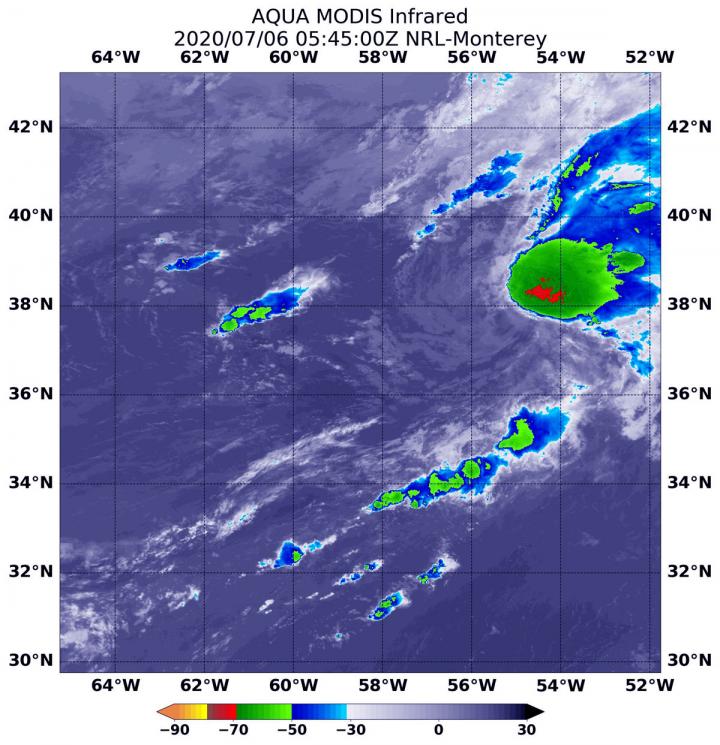
On July 6 at 1:45 a.m. EDT (0545 UTC), the MODIS instrument aboard NASA’s Aqua satellite analyzed Tropical Storm Edouard’s cloud tops in infrared light. Infrared data provides temperature information, and the strongest thunderstorms that reach high into the atmosphere have the coldest cloud top temperatures.
The Moderate Resolution Imaging Spectroradiometer or MODIS instrument aboard NASA’s Aqua satellite found a small area of powerful thunderstorms northeast of the center of circulation, where temperatures were as cold as or colder than minus 70 degrees Fahrenheit (minus 56.6 Celsius). Cloud top temperatures that cold indicate strong storms with the potential to generate heavy rainfall. Southwesterly wind shear was pushing the strongest storms northeast of the tropical cyclone’s center. Satellite imagery indicates that the rest of Edouard was comprised of an exposed swirl of low- to mid-level clouds.
In general, wind shear is a measure of how the speed and direction of winds change with altitude. Tropical cyclones are like rotating cylinders of winds. Each level needs to be stacked on top each other vertically in order for the storm to maintain strength or intensify. Wind shear occurs when winds at different levels of the atmosphere push against the rotating cylinder of winds, weakening the rotation by pushing it apart at different levels. Winds from the west were displacing the bulk of clouds and showers from Edouard and pushing them to the east.
At 5 a.m. EDT (0900 UTC) on July 6, the center of Tropical Storm Edouard was located near latitude 39.0 degrees north and longitude 53.6 degrees west. It was centered about 530 miles (855 km) south of Cape Race, Newfoundland, Canada. Maximum sustained winds were near 40 mph (65 kph) with higher gusts. The estimated minimum central pressure is 1008 millibars.
Little significant change in strength is forecast before Edouard becomes post-tropical later in the day. Edouard was moving toward the northeast near 36 mph (57 kph) and this motion is expected to continue for the next couple of days, as it tracks toward the United Kingdom.
National Hurricane Center forecaster Jack Beven noted, “The cyclone is located in a region of strong southwesterly vertical wind shear, is heading for colder water, and is approaching a frontal system. This combination should lead to extratropical transition between 12 to 24 hours, and it is possible that Edouard could strengthen a little as transition occurs. After transition, the extratropical low should persist for another 24 hours or so before the circulation dissipates.”
Typhoons/hurricanes are the most powerful weather events on Earth. NASA’s expertise in space and scientific exploration contributes to essential services provided to the American people by other federal agencies, such as hurricane weather forecasting.
###
By Rob Gutro
NASA’s Goddard Space Flight Center
Media Contact
Rob Gutro
[email protected]
Original Source
https:/


