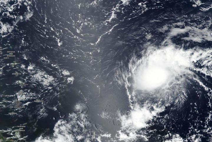
Credit: Credit: NASA Worldview, Earth Observing System Data and Information System (EOSDIS)
NASA-NOAA’s Suomi NPP satellite provided forecasters with a visible image of Tropical Storm Josephine east of the Lesser Antilles island chain. Suomi NPP revealed that Josephine was being affected by wind shear.
The Lesser Antilles is a group of islands that form the boundary of the western Atlantic Ocean and the Caribbean Sea (to the west). They are a long, partly volcanic island arc stretching between the Greater Antilles to the north-west and South America.
On Aug. 13, the Visible Infrared Imaging Radiometer Suite (VIIRS) instrument aboard Suomi NPP revealed southwesterly wind shear was pushing the bulk of clouds and precipitation to the northeast of the center, giving the storm an elongated appearance.
Vertical wind shear, that is, winds outside of a tropical cyclone at different heights in the atmosphere (the troposphere), pushes against a tropical cyclone and tears it apart.
On Aug. 14, National Hurricane Center hurricane forecaster Jack Beven noted that wind shear was continuing. Beven said, “Morning visible satellite imagery indicates that the center of Josephine is located to the south or southwest of the strongest area of convection, likely due to the onset of southwesterly vertical wind shear.”
Tropical Storm Josephine on Aug. 14
At 11 a.m. EDT (1500 UTC) on Aug. 14, the center of Tropical Storm Josephine was located near latitude 16.1 degrees north and longitude 54.7 degrees west. The storm was centered 575 miles (920 km) east-southeast of the southern Leeward Islands.
Josephine is moving toward the west-northwest near 16 mph (26 kph), and this general motion is expected to continue for the next couple of days. The estimated minimum central pressure was 1006 millibars. Maximum sustained winds were near 40 mph (65 km/h) with higher gusts. Some strengthening is possible during the next 24 hours. After that time, Josephine is expected to encounter upper-level winds that will not be conducive for strengthening.
Josephine is expected to turn toward the northwest late this weekend or early next week. On the forecast track, the center of Josephine is expected to pass to the northeast of the Leeward Islands over the weekend.
NASA Researches Tropical Cyclones
Hurricanes/tropical cyclones are the most powerful weather events on Earth. NASA’s expertise in space and scientific exploration contributes to essential services provided to the American people by other federal agencies, such as hurricane weather forecasting.
For more than five decades, NASA has used the vantage point of space to understand and explore our home planet, improve lives and safeguard our future. NASA brings together technology, science, and unique global Earth observations to provide societal benefits and strengthen our nation. Advancing knowledge of our home planet contributes directly to America’s leadership in space and scientific exploration.
###
For updated forecasts. visit: http://www.
By Rob Gutro
NASA’s Goddard Space Flight Center
Media Contact
Rob Gutro
[email protected]
Original Source
https:/


