Credit: NASA Worldview
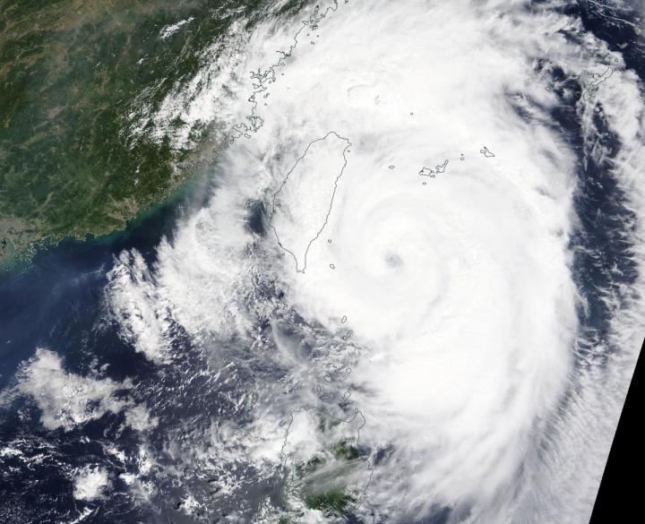
NASA’s Terra satellite captured an image of Typhoon Mitag’s cloud-filled eye, located east of Taiwan.
On Sept. 30, the Moderate Imaging Spectroradiometer or MODIS instrument that flies aboard NASA’s Terra satellite provided a visible image of Mitag. The MODIS image showed the cyclone continues to produce strong thunderstorms around its cloud-filled eye. Mitag’s western quadrant had already spread clouds and precipitation over Taiwan. Powerful bands of thunderstorms were swirling into the low-level center from the eastern side of the storm.
On Sept. 30, warnings remain in effect for the Philippines as Mitag, known locally as Onyok, continues to move north and away from the country. Philippines warnings still in effect include wind signal #1 for the Luzon provinces of Batanes and Babuyan Islands.
At 5 a.m. EDT (0900 UTC), Typhoon Mitag had maximum sustained winds near 75 knots. It was located near 22.8 degrees north latitude and 123.0 degrees east longitude, about 161 nautical miles south-southeast of Taipei, Taiwan.
Mitag is moving north, close to the east coast of Taiwan and forecasters at the Joint Typhoon Warning Center noted that Mitag is at peak intensity. The storm is forecast to graze the east coast of China, south of Shanghai, and then turn northeast.
NASA’s Terra satellite is one in a fleet of NASA satellites that provide data for hurricane research.
Hurricanes are the most powerful weather event on Earth. NASA’s expertise in space and scientific exploration contributes to essential services provided to the American people by other federal agencies, such as hurricane weather forecasting.
For updated forecasts, visit: https:/
###
Media Contact
Rob Gutro
[email protected]
Original Source
https:/


