Credit: Image Courtesy: NASA Worldview, Earth Observing System Data and Information System (EOSDIS).
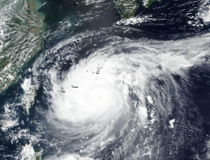
Typhoon Maysak continued to move through the Northwestern Pacific and was closing in on Japan’s Okinawa Island when NASA’s Terra satellite obtained a visible image of the storm. Maysak’s eye is not expected to go over the island, but pass just west of it.
The Moderate Resolution Imaging Spectroradiometer or MODIS instrument that flies aboard NASA’s Terra satellite captured a visible image of Typhoon Maysak. Imagery showed the eye of the storm appeared filled with high clouds, as powerful bands of thunderstorm circled it. Bands of thunderstorms from the south were spiraling into the low-level center.
On Aug. 31 at 5 a.m. EDT (0900 UTC), Typhoon Maysak was located about 144 nautical miles south of Kadena Air Base, Okinawa Island, Japan. It was moving to the north-northwest and had maximum sustained winds near 100 knots (115 mph/185 kph).
Maysak’s center is expected to pass just west of Okinawa within 24 hours. The storm is expected to make landfall in southern South Korea and will start to become extra-tropical.
About NASA’s Worldview and Terra Satellite
NASA’s Earth Observing System Data and Information System (EOSDIS) Worldview application provides the capability to interactively browse over 700 global, full-resolution satellite imagery layers and then download the underlying data. Many of the available imagery layers are updated within three hours of observation, essentially showing the entire Earth as it looks “right now.”
NASA’s Terra satellite is one in a fleet of NASA satellites that provide data for hurricane research.
Tropical cyclones/hurricanes are the most powerful weather events on Earth. NASA’s expertise in space and scientific exploration contributes to essential services provided to the American people by other federal agencies, such as hurricane weather forecasting.
By Rob Gutro
NASA’s Goddard Space Flight Center
###
Media Contact
Rob Gutro
[email protected]
Original Source
https:/


