Credit: Credit: NASA/NRL
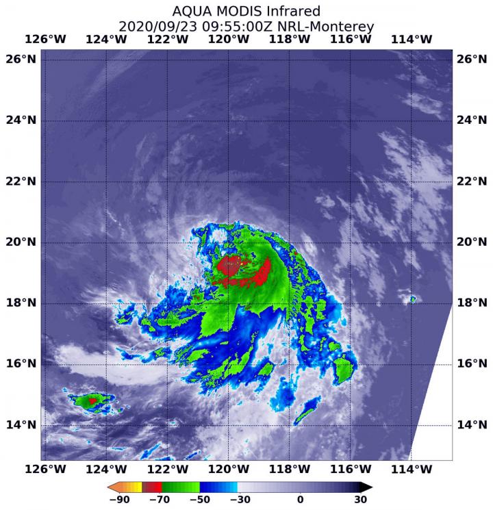
NASA’s Aqua satellite used infrared light to identify strongest storms and coldest cloud top temperatures in Tropical Storm Lowell and found them south of the center of circulation.
Lowell is moving through the Eastern Pacific Ocean and far from land areas. There are no coastal watches or warnings in effect.
Infrared Data Reveals Powerful Storms
On Sept. 23 at 5:55 a.m. EDT (0955 UTC), the Moderate Resolution Imaging Spectroradiometer or MODIS instrument aboard NASA’s Aqua satellite gathered temperature information about Lowell’s cloud tops. Infrared data provides temperature information, and the strongest thunderstorms that reach high into the atmosphere have the coldest cloud top temperatures.
MODIS found the most powerful thunderstorms were south of the center, where temperatures were as cold as or colder than minus 70 degrees Fahrenheit (minus 56.6 Celsius). Cloud top temperatures that cold indicate strong storms with the potential to generate heavy rainfall.
Lowell’s center is located near the northern edge of a band of strong thunderstorms and deep convection which extends over the eastern and southern portion of the circulation due to moderate northwesterly wind shear in the mid-levels below the cirrus layer (high cloud).
Lowell’s Status on Sept. 23
At 5 a.m. EDT (0900 UTC) on Sept. 23, the center of Tropical Storm Lowell was located near latitude 19.8 degrees north and longitude 119.9 degrees west. Lowell is centered about 680 miles (1,090 km) west-southwest of the southern tip of Baja California, Mexico.
Lowell is moving toward the west-northwest near 12 mph (19 kph), and this general motion is expected to continue today. Maximum sustained winds have increased to near 50 mph (85 kph) with higher gusts. The estimated minimum central pressure is 1001 millibars.
Lowell’s Forecast
NOAA’s National Hurricane Center expects Lowell to move in a westward motion beginning early Thursday, Sept. 24 and continue into the weekend. Little change in strength is forecast during the next few days.
NASA Researches Tropical Cyclones
Hurricanes/tropical cyclones are the most powerful weather events on Earth. NASA’s expertise in space and scientific exploration contributes to essential services provided to the American people by other federal agencies, such as hurricane weather forecasting.
For more than five decades, NASA has used the vantage point of space to understand and explore our home planet, improve lives and safeguard our future. NASA brings together technology, science, and unique global Earth observations to provide societal benefits and strengthen our nation. Advancing knowledge of our home planet contributes directly to America’s leadership in space and scientific exploration.
For forecast updates on hurricanes, visit: http://www.
By Rob Gutro
NASA’s Goddard Space Flight Center
###
Media Contact
Rob Gutro
[email protected]
Original Source
https:/


