Credit: Credit: NASA/NRL
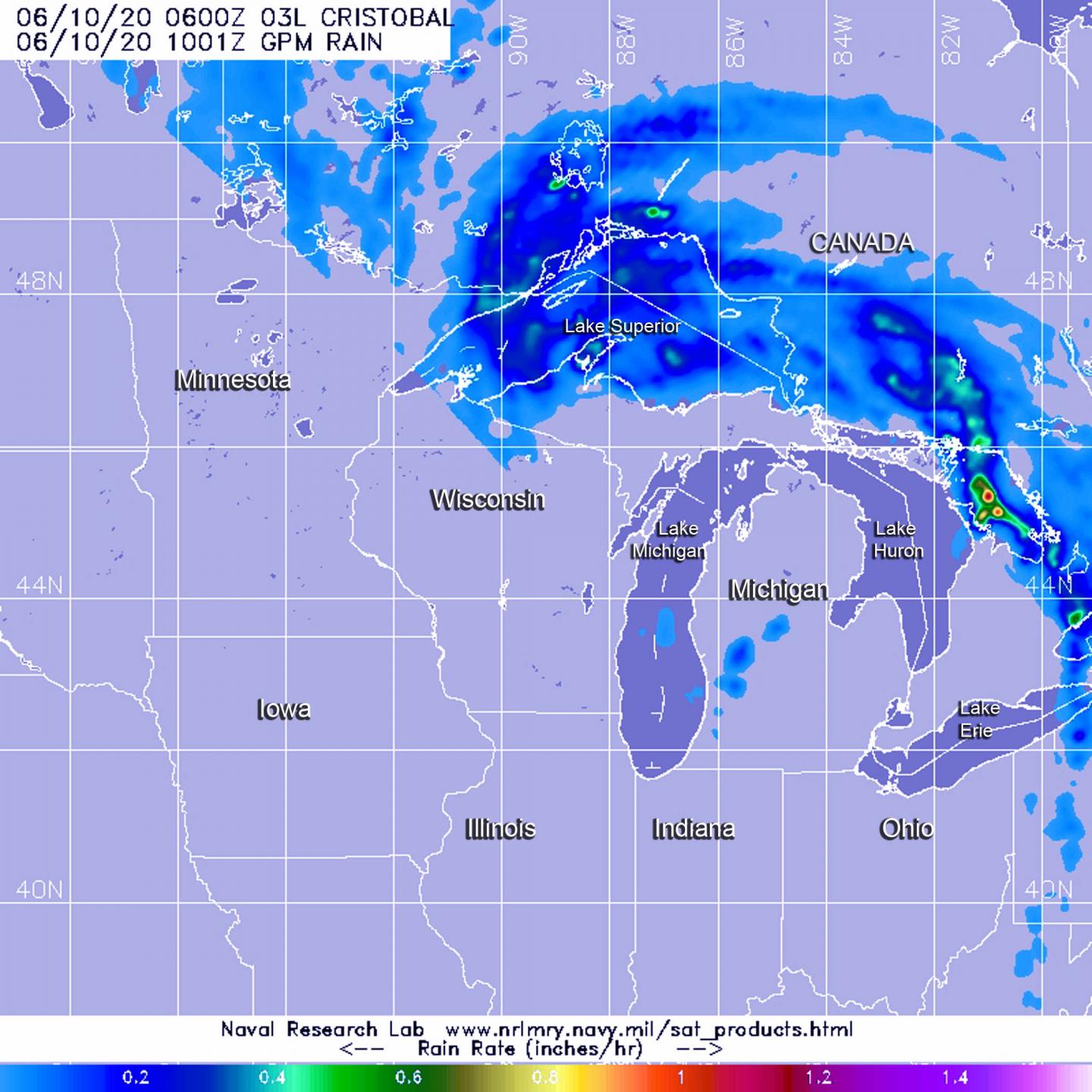
NASA’s GPM satellite gathered data on what is now Post-Tropical Cyclone Cristobal and revealed some areas of heavy rain were occurring. Cristobal was bringing rainfall and gusty winds to the Great Lakes Region and still generating warnings.
Warnings and Advisories
On June 10, Cristobal was designated a post-tropical cyclone and the storm has triggered several watches and warnings in the Great Lakes area. The National Weather Service’s Weather Prediction Center (WPC) in College Park, Md. issued a Lakeshore Flood Warning for the northern shores of Lake St. Clair. Lakeshore Flood Advisories are in effect for the Lake Michigan shoreline of northern Lower Michigan, the Lake Michigan shoreline of Upper Michigan and the Lake Huron shoreline of Upper Michigan.
In addition, a Gale Warning is in effect for Lake Michigan, eastern Lake Superior and portions of Lake Huron. Wind Advisories are in effect for parts of Wisconsin and Michigan.
What is a Post-tropical Cyclone?
NOAA’s National Hurricane Center defines a Post-tropical cyclone as a former tropical cyclone. This generic term describes a cyclone that no longer possesses sufficient tropical characteristics to be considered a tropical cyclone. Post-tropical cyclones can continue carrying heavy rains and high winds. Former tropical cyclones that have become fully extratropical and remnant lows are two classes of post-tropical cyclones.
Rainfall Estimates
When the Global Precipitation Measurement mission or GPM core satellite passed over Cristobal on June 10 at 2 a.m. EDT (0600 UTC). GPM found heaviest rainfall occurring in two areas. One area was north and west of Lake Superior, north of Rossport and Red Rock, Ontario, Canada. The second area was over Georgian Bay on the eastern side of Lake Huron. In both places, rain was falling at rates of 1 inch (25 mm) per hour. Light rain appears stretched around the northern and eastern side of the system, falling at less than 0.2 inches (less than 5 millimeters) per hour.
Forecast Rainfall
The WPC noted, “The primary rainfall threat with Cristobal has ended. Sporadic heavy rain is possible today across the Great Lakes, along and ahead of a cold front associated with extratropical Cristobal. Minor to moderate river flooding will continue across portions of the Mississippi Valley.”
Cristobal’s Status on Wednesday, June 10, 2020
At 5 a.m. EDT (0900 UTC) on June 10, the center of Post-Tropical Cyclone Cristobal was located near latitude 45.8 degrees north and longitude 88.2 degrees west. That places the center about 195 miles (310 km) north-northeast of Madison, Wisconsin and about 185 miles (295 km) west of Sault Ste. Marie, Michigan. The post-tropical cyclone is moving toward the north-northeast near 30 mph (48 kph) and this motion is expected to continue as Cristobal tracks into Ontario, Canada.
Maximum sustained winds are near 40 mph (65 kph) with higher gusts. Little change in strength is forecast during the next 48 hours. The estimated minimum central pressure is 983 millibars.
Cristobal’s Forecast Path
WPC noted that in addition to rainfall, winds gusting over 40 mph are expected early during the morning of June 10 over portions of Wisconsin and Michigan close to the Great Lakes. In addition, a few tornadoes are possible today across in the Great Lakes region, with the greatest chances in parts of Michigan, Indiana and Ohio.
Tropical cyclones/hurricanes are the most powerful weather events on Earth. NASA’s expertise in space and scientific exploration contributes to essential services provided to the American people by other federal agencies, such as hurricane weather forecasting.
GPM is a joint mission between NASA and the Japan Aerospace Exploration Agency, JAXA. The Suomi NPP satellite is a joint mission with NASA and NOAA.
For updated forecasts, visit: http://www.
###
Media Contact
Rob Gutro
[email protected]
Original Source
https:/


