• HOME
  • NEWS
  • EXPLORE
    • CAREER
      • Companies
      • Jobs
    • EVENTS
    • iGEM
      • News
      • Team
    • PHOTOS
    • VIDEO
    • WIKI
  • BLOG
  • COMMUNITY
    • FACEBOOK
    • INSTAGRAM
    • TWITTER
Wednesday, December 17, 2025
BIOENGINEER.ORG
No Result
View All Result
  • Login
  • HOME
  • NEWS
  • EXPLORE
    • CAREER
      • Companies
      • Jobs
        • Lecturer
        • PhD Studentship
        • Postdoc
        • Research Assistant
    • EVENTS
    • iGEM
      • News
      • Team
    • PHOTOS
    • VIDEO
    • WIKI
  • BLOG
  • COMMUNITY
    • FACEBOOK
    • INSTAGRAM
    • TWITTER
No Result
View All Result
Bioengineer.org
No Result
View All Result
Home NEWS Science News

NASA finds Kiko weakening in the Eastern Pacific

Bioengineer by Bioengineer
September 16, 2019
in Science News
Reading Time: 3 mins read
0
IMAGE
Share on FacebookShare on TwitterShare on LinkedinShare on RedditShare on Telegram

IMAGE

Credit: NASA JPL/Heidar Thrastarson

NASA’s Aqua satellite provided forecasters at the National Hurricane Center with infrared data and cloud top temperature information on Hurricane Kiko. Wind shear was affecting the storm and had closed the eye.

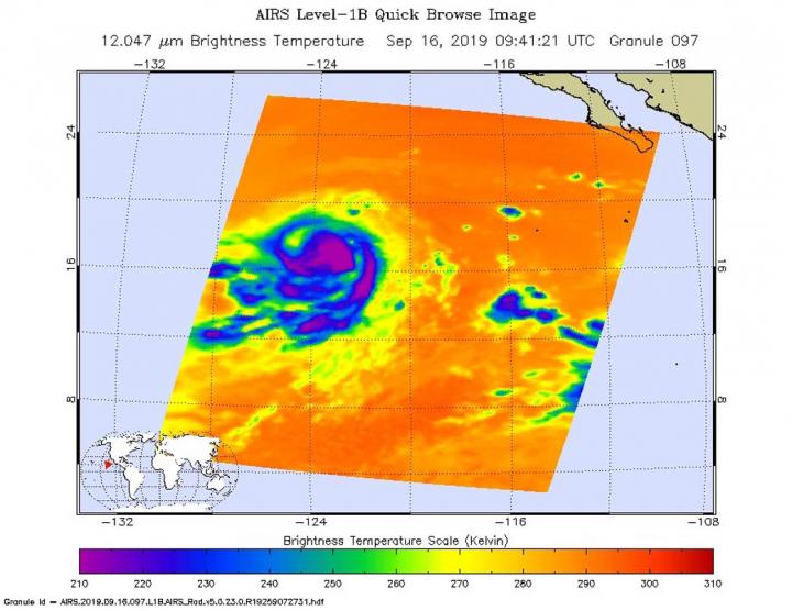
On Monday, September 16, 2019, microwave data and satellite imagery continue to indicate that the core of Kiko is being disrupted. Wind shear from the northeast is preventing Kiko from having a closed eyewall circulation. That means that the storm is subject to outside winds and can weaken.

NASA researches tropical cyclones. One of the ways NASA does that is with infrared data that provides temperature information. Cloud top temperatures provide information to forecasters about where the strongest storms are located within a tropical cyclone. Tropical cyclones do not always have uniform strength, and some sides have stronger sides than others. The stronger the storms, the higher they extend into the troposphere, and they have the colder cloud temperatures.

NASA’s Aqua satellite analyzed the storm on Sept. 8 at 11.59 p.m. EDT (Sept. 9 at 0359 UTC) using the Atmospheric Infrared Sounder or AIRS instrument. The AIRS instrument is one of six instruments flying on board NASA’s Aqua satellite, launched on May 4, 2002.

The AIRS infrared data no longer showed an eye in Kiko, indicating that the wind shear from the northeast had filled the center with clouds.

In general, wind shear is a measure of how the speed and direction of winds change with altitude. Tropical cyclones are like rotating cylinders of winds. Each level needs to be stacked on top each other vertically in order for the storm to maintain strength or intensify. Wind shear occurs when winds at different levels of the atmosphere push against the rotating cylinder of winds, weakening the rotation by pushing it apart at different levels.

AIRS found coldest cloud top temperatures as cold as or colder than minus 63 degrees Fahrenheit (minus 53 degrees Celsius) around Kiko’s center and in a large bands east and west of center. NASA research has shown that cloud top temperatures that cold indicate strong storms that have the capability to create heavy rain.

At 11 a.m. EDT (1500 UTC), the center of Hurricane Kiko was located near latitude 17.3 degrees north and longitude 123.7 degrees west. That put the center about 975 miles (1,570 km) west-southwest of the southern tip of Baja Calfiornia, Mexico. Kiko is moving toward the west near 5 mph (7 kph), and this motion is expected to continue through tonight.

Maximum sustained winds have decreased to near 105 mph (165 kph) with higher gusts. Kiko is a small tropical cyclone. Hurricane-force winds extend outward up to 15 miles (30 km) from the center and tropical-storm-force winds extend outward up to 60 miles (95 km). The estimated minimum central pressure is 971 millibars.

NHC forecasters expect a west-southwestward motion on Sept. 17 followed by a turn back to the west on Wednesday. Gradual weakening is expected during the next couple of days.

###

For updated forecasts, visit: http://www.nhc.noaa.gov

Rob Gutro

NASA’s Goddard Space Flight Center

Media Contact
Rob Gutro
[email protected]

Original Source

https://blogs.nasa.gov/hurricanes/2019/09/16/kiko-eastern-pacific/

Tags: Atmospheric ChemistryAtmospheric ScienceClimate ChangeClimate ScienceEarth ScienceMeteorologyTechnology/Engineering/Computer ScienceTemperature-Dependent PhenomenaWeather/Storms
Share12Tweet8Share2ShareShareShare2

Related Posts

Revolutionary rGO/CeFe2O4 Nanohybrid: Multi-Functional Applications Explored

Revolutionary rGO/CeFe2O4 Nanohybrid: Multi-Functional Applications Explored

December 17, 2025

Enhanced Leuprolide Acetate Delivery via SNEDDS Technology

December 17, 2025

AI-Driven SPOT Imaging Enhances Myocardial Scar Detection

December 17, 2025

Programmable 200 GOPS Photonic Ising Machine

December 17, 2025
Please login to join discussion

POPULAR NEWS

  • Nurses’ Views on Online Learning: Effects on Performance

    Nurses’ Views on Online Learning: Effects on Performance

    70 shares
    Share 28 Tweet 18
  • NSF funds machine-learning research at UNO and UNL to study energy requirements of walking in older adults

    70 shares
    Share 28 Tweet 18
  • MoCK2 Kinase Shapes Mitochondrial Dynamics in Rice Fungal Pathogen

    72 shares
    Share 29 Tweet 18
  • Unraveling Levofloxacin’s Impact on Brain Function

    52 shares
    Share 21 Tweet 13

About

We bring you the latest biotechnology news from best research centers and universities around the world. Check our website.

Follow us

Recent News

Revolutionary rGO/CeFe2O4 Nanohybrid: Multi-Functional Applications Explored

Enhanced Leuprolide Acetate Delivery via SNEDDS Technology

AI-Driven SPOT Imaging Enhances Myocardial Scar Detection

Subscribe to Blog via Email

Enter your email address to subscribe to this blog and receive notifications of new posts by email.

Join 70 other subscribers
  • Contact Us

Bioengineer.org © Copyright 2023 All Rights Reserved.

Welcome Back!

Login to your account below

Forgotten Password?

Retrieve your password

Please enter your username or email address to reset your password.

Log In
No Result
View All Result
  • Homepages
    • Home Page 1
    • Home Page 2
  • News
  • National
  • Business
  • Health
  • Lifestyle
  • Science

Bioengineer.org © Copyright 2023 All Rights Reserved.