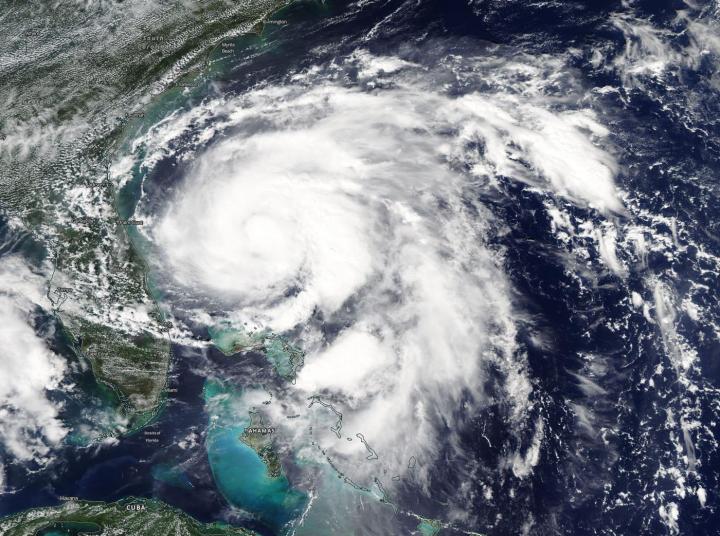
Credit: NASA Worldview, Earth Observing System Data and Information System (EOSDIS)
NASA’s Aqua Satellite provided a visible image of Tropical Storm Humberto as it was strengthening off the Florida coast on Sept. 15. Humberto became a hurricane late in the day.
On Sept. 15, the Moderate Imaging Spectroradiometer or MODIS instrument that flies aboard NASA’s Aqua satellite provided a visible image of Tropical Storm Humberto spinning off the eastern coast of Florida and strengthening. Powerful thunderstorms circled the center and a large band of thunderstorms wrapped into the low-level center from the east. Humberto became a hurricane on Sept. 15 at 11 p.m. EDT.
On that day at 2:11 p.m. EDT (1811 UTC) the Atmospheric Infrared Sounder (AIRS) instrument aboard NASA’s Aqua satellite analyzed Humberto’s cloud top temperatures in infrared light. AIRS found coldest cloud top temperatures (purple) of strongest thunderstorms were as cold as or colder than minus 63 degrees Fahrenheit (minus 53 degrees Celsius) around the center. NASA research has shown that storms with cloud top temperatures that cold can produce heavy rainfall.
On Sept. 16, Humberto was stirring up the seas and creating hazardous conditions. Humberto continued to get better organized to the west of Bermuda and was pushing large swells that were affecting much of the southeastern United States coastline. The National Hurricane Center (NHC) cautioned that interests in and around Bermuda should monitor the progress of Humberto since a Tropical Storm Watch will likely be required for Bermuda later in the day.
At 11 a.m. EDT (1500 UTC), the center of Hurricane Humberto was located near latitude 29.9 degrees north and longitude 76.5 degrees west making the center about 710 miles (1,145 km) west of Bermuda. Humberto is moving toward the east-northeast near 7 mph (11 kph). This general motion with a gradual increase in forward speed is expected through early Thursday.
Data from an Air Force Reserve reconnaissance aircraft indicate that maximum sustained winds are near 85 mph (140 kph) with higher gusts. The minimum central pressure recently measured by reconnaissance aircraft was 978 millibars.
In the NHC discussion, Forecaster Stacy Stewart noted, “Humberto has been strengthening at a rate of 20 knots per 24 hours since this time yesterday, and that trend is expected to continue for the next day or so given the warm water beneath the hurricane and a continued favorable upper-level outflow pattern. The hurricane is expected to peak as a major hurricane in 36 to 48 hours/”
On the forecast track, the center of Humberto is forecast to approach Bermuda Wednesday night, Sept. 18. NHC forecasters said that strengthening is expected during the next 48 hours, and Humberto could become a major hurricane by Tuesday night, Sept. 17.
###
For updated forecasts, visit: http://www.
Rob Gutro
NASA’s Goddard Space Flight Center, Greenbelt, Md.
Media Contact
Rob Gutro
[email protected]
Original Source
https:/


