• HOME
  • NEWS
  • EXPLORE
    • CAREER
      • Companies
      • Jobs
    • EVENTS
    • iGEM
      • News
      • Team
    • PHOTOS
    • VIDEO
    • WIKI
  • BLOG
  • COMMUNITY
    • FACEBOOK
    • INSTAGRAM
    • TWITTER
Tuesday, December 23, 2025
BIOENGINEER.ORG
No Result
View All Result
  • Login
  • HOME
  • NEWS
  • EXPLORE
    • CAREER
      • Companies
      • Jobs
        • Lecturer
        • PhD Studentship
        • Postdoc
        • Research Assistant
    • EVENTS
    • iGEM
      • News
      • Team
    • PHOTOS
    • VIDEO
    • WIKI
  • BLOG
  • COMMUNITY
    • FACEBOOK
    • INSTAGRAM
    • TWITTER
No Result
View All Result
Bioengineer.org
No Result
View All Result
Home NEWS Science News

NASA finds heavy water vapor concentration rings eye of Cyclone Amphan

Bioengineer by Bioengineer
May 18, 2020
in Science News
Reading Time: 2 mins read
0
IMAGE
Share on FacebookShare on TwitterShare on LinkedinShare on RedditShare on Telegram

IMAGE

Credit: Credits: NASA/NRL

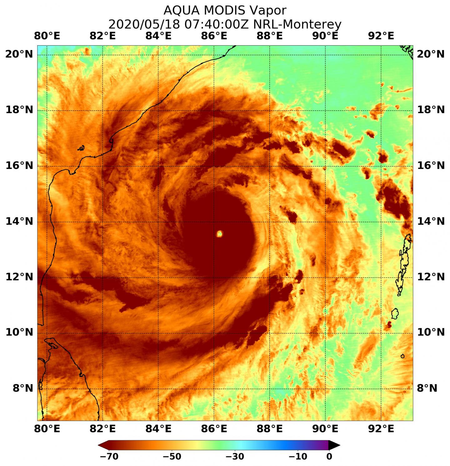
When NASA’s Aqua satellite passed over the Northern Indian Ocean on May 18, it gathered water vapor data that showed the intensity of powerful Tropical Cyclone Amphan. Amphan is the equivalent of a Category 5 hurricane on the Saffir-Simpson Hurricane Wind Scale.

Water vapor analysis of tropical cyclones tells forecasters how much potential a storm has to develop. Water vapor releases latent heat as it condenses into liquid. That liquid becomes clouds and thunderstorms that make up a tropical cyclone. Temperature is important when trying to understand how strong storms can be. The higher the cloud tops, the colder and the stronger the storms.

NASA’s Aqua satellite passed over Tropical Cyclone Amphan on May 18 at 3:40 a.m. EST (0740 UTC), and the Moderate Resolution Imaging Spectroradiometer or MODIS instrument gathered water vapor content and temperature information. The MODIS image showed highest concentrations of water vapor and coldest cloud top temperatures circled the visible eye.

MODIS data showed coldest cloud top temperatures were as cold as or colder than minus 70 degrees Fahrenheit (minus 56.6 degrees Celsius) in those storms. Storms with cloud top temperatures that cold have the capability to produce heavy rainfall.

NASA-NOAA’s Suomi NPP satellite provided a visible image of the huge Tropical Cyclone Amphan on May 18, just off the eastern coast of India. The image showed the extent of the storm, which was over open ocean, stretching from just north of Sri Lanka, north, past the Indian states of Tamil Nadu to Andrha Pradesh.

At 5 a.m. EDT (0900 UTC) on May 18, the Joint Typhoon Warning Center (JTWC) noted that Amphan’s eye was centered near latitude 13.6 degrees north and longitude 86.4 degrees east, about 301 nautical miles southeast of Visakhapatnam, India. Amphan was moving to the north and had maximum sustained winds 140 knots (161 mph/259 kph).

Amphan will move north and is expected to strengthen slightly. JTWC said the storm will then gradually weaken prior to landfall near Kolkata, India in two days.

NASA’s Aqua satellite is one in a fleet of NASA satellites that provide data for hurricane research.

Tropical cyclones/hurricanes are the most powerful weather events on Earth. NASA’s expertise in space and scientific exploration contributes to essential services provided to the American people by other federal agencies, such as hurricane weather forecasting.

###

Media Contact
Rob Gutro
[email protected]

Original Source

https://blogs.nasa.gov/hurricanes/2020/05/18/amphan-northern-indian-ocean-2/

Tags: Atmospheric ChemistryAtmospheric ScienceClimate ChangeClimate ScienceEarth ScienceMeteorologyTechnology/Engineering/Computer ScienceTemperature-Dependent PhenomenaWeather/Storms
Share12Tweet8Share2ShareShareShare2

Related Posts

blank

Hydrocolloids Boost Orally Disintegrating Film Performance

December 23, 2025

Muscle Bursting Signals Impulse Control Issues in Parkinson’s

December 23, 2025

Racial Gaps in Cardiovascular Risk Control in Obesity

December 23, 2025

Revolutionary Micro-CT and AI Evaluate Ovarian Follicles

December 23, 2025
Please login to join discussion

POPULAR NEWS

  • Nurses’ Views on Online Learning: Effects on Performance

    Nurses’ Views on Online Learning: Effects on Performance

    70 shares
    Share 28 Tweet 18
  • NSF funds machine-learning research at UNO and UNL to study energy requirements of walking in older adults

    71 shares
    Share 28 Tweet 18
  • Unraveling Levofloxacin’s Impact on Brain Function

    54 shares
    Share 22 Tweet 14
  • Exploring Audiology Accessibility in Johannesburg, South Africa

    51 shares
    Share 20 Tweet 13

About

We bring you the latest biotechnology news from best research centers and universities around the world. Check our website.

Follow us

Recent News

Hydrocolloids Boost Orally Disintegrating Film Performance

Muscle Bursting Signals Impulse Control Issues in Parkinson’s

Racial Gaps in Cardiovascular Risk Control in Obesity

Subscribe to Blog via Email

Enter your email address to subscribe to this blog and receive notifications of new posts by email.

Join 70 other subscribers
  • Contact Us

Bioengineer.org © Copyright 2023 All Rights Reserved.

Welcome Back!

Login to your account below

Forgotten Password?

Retrieve your password

Please enter your username or email address to reset your password.

Log In
No Result
View All Result
  • Homepages
    • Home Page 1
    • Home Page 2
  • News
  • National
  • Business
  • Health
  • Lifestyle
  • Science

Bioengineer.org © Copyright 2023 All Rights Reserved.