• HOME
  • NEWS
  • EXPLORE
    • CAREER
      • Companies
      • Jobs
    • EVENTS
    • iGEM
      • News
      • Team
    • PHOTOS
    • VIDEO
    • WIKI
  • BLOG
  • COMMUNITY
    • FACEBOOK
    • INSTAGRAM
    • TWITTER
Wednesday, September 10, 2025
BIOENGINEER.ORG
No Result
View All Result
  • Login
  • HOME
  • NEWS
  • EXPLORE
    • CAREER
      • Companies
      • Jobs
        • Lecturer
        • PhD Studentship
        • Postdoc
        • Research Assistant
    • EVENTS
    • iGEM
      • News
      • Team
    • PHOTOS
    • VIDEO
    • WIKI
  • BLOG
  • COMMUNITY
    • FACEBOOK
    • INSTAGRAM
    • TWITTER
No Result
View All Result
Bioengineer.org
No Result
View All Result
Home NEWS Science News

NASA finds heavy rain potential in typhoon Bualoi over Marianas

Bioengineer by Bioengineer
October 22, 2019
in Science News
Reading Time: 2 mins read
0
IMAGE
Share on FacebookShare on TwitterShare on LinkedinShare on RedditShare on Telegram

IMAGE

Credit: Credit: NASA JPL/Heidar Thrastarson


Typhoon Bualoi was lashing the Marianas Islands in the Northwestern Pacific Ocean when NASA’s Aqua satellite passed overhead and analyzed the cloud top temperatures to give forecasters insight into the storm’s rain potential.

On Oct. 22, a Tropical Storm Warning remained in effect for the islands of Agrihan, Pagan and Alamagan in the Northern Mariana Islands.

One of the ways NASA researches tropical cyclones is by using infrared data that provides temperature information. Cloud top temperatures identify where the strongest storms are located. The stronger the storms, the higher they extend into the troposphere, and the colder the cloud top temperatures.

Tropical cyclones do not always have uniform strength, and some sides have stronger sides than others, so knowing where the strongest sides of the storms are located helps forecasters. NASA then provides data to tropical cyclone meteorologists so they can incorporate the data in their forecasts.

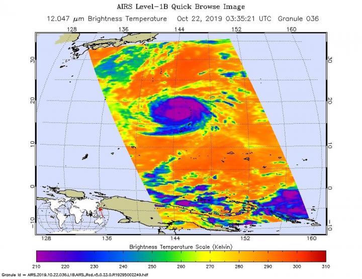
On Oct. 22 at 0335 UTC (Oct. 21 at 11:35 p.m. EDT) NASA’s Aqua satellite analyzed the storm using the Atmospheric Infrared Sounder or AIRS instrument. AIRS found coldest cloud top temperatures as cold as or colder 210 Kelvin (purple) which is minus 81 degrees Fahrenheit (minus 63.1 degrees Celsius) around the center. NASA research has shown that cloud top temperatures that cold indicate strong storms that have the capability to create heavy rain.

The AIRS infrared imagery also hinted at an eye, but the eye was more apparent in the AIRS microwave imagery. The Joint Typhoon Warning Center estimated that the eye is about 8 nautical miles wide.

At 11 a.m. EDT (1 a.m. CHST local time/1500 UTC) NOAA’s National Weather Service (NWS) in Tiyan, Guam noted that the center of Typhoon Bualoi was located near latitude 19.7 degrees north and longitude 143.2 degrees east. That puts the eye about 175 miles west-northwest of Agrihan, and about 440 miles north-northwest of Guam.

Bualoi is moving northwest at 16 mph. It is expected to make a slight turn toward the north-northwest with a slight decrease in forward speed over the next 24 hours. Maximum sustained winds have increased to 145 mph. Bualoi is forecast to intensify through Thursday and then begin weakening as it moves in a northerly track.

Hurricanes are the most powerful weather event on Earth. NASA’s expertise in space and scientific exploration contributes to essential services provided to the American people by other federal agencies, such as hurricane weather forecasting.

The AIRS instrument is one of six instruments flying on board NASA’s Aqua satellite, launched on May 4, 2002.

###

For updated forecasts, visit: https://www.weather.gov/gum/Cyclones

By Rob Gutro

NASA’s Goddard Space Flight Center  

Media Contact
Rob Gutro
[email protected]

Original Source

https://blogs.nasa.gov/hurricanes/2019/10/22/bualoi-western-pacific-ocean-2/

Tags: Atmospheric ChemistryAtmospheric ScienceClimate ChangeClimate ScienceEarth ScienceMeteorologyTechnology/Engineering/Computer ScienceTemperature-Dependent PhenomenaWeather/Storms
Share13Tweet8Share2ShareShareShare2

Related Posts

Fast Imaging Screen Finds Potent SKP2 Oncoprotein Degrader

September 10, 2025

Grid Cells Accurately Track Movement Amid Reference Switch

September 10, 2025

Boosting PPARγ Upregulates NECTIN4, Enhances CAR-T

September 10, 2025

Stable 4-(N-Carbazolyl)pyridine Boosts Perovskite Solar Cells

September 10, 2025
Please login to join discussion

POPULAR NEWS

  • blank

    Breakthrough in Computer Hardware Advances Solves Complex Optimization Challenges

    151 shares
    Share 60 Tweet 38
  • New Drug Formulation Transforms Intravenous Treatments into Rapid Injections

    116 shares
    Share 46 Tweet 29
  • Physicists Develop Visible Time Crystal for the First Time

    53 shares
    Share 21 Tweet 13
  • First Confirmed Human Mpox Clade Ib Case China

    56 shares
    Share 22 Tweet 14

About

We bring you the latest biotechnology news from best research centers and universities around the world. Check our website.

Follow us

Recent News

Fast Imaging Screen Finds Potent SKP2 Oncoprotein Degrader

Grid Cells Accurately Track Movement Amid Reference Switch

Boosting PPARγ Upregulates NECTIN4, Enhances CAR-T

  • Contact Us

Bioengineer.org © Copyright 2023 All Rights Reserved.

Welcome Back!

Login to your account below

Forgotten Password?

Retrieve your password

Please enter your username or email address to reset your password.

Log In
No Result
View All Result
  • Homepages
    • Home Page 1
    • Home Page 2
  • News
  • National
  • Business
  • Health
  • Lifestyle
  • Science

Bioengineer.org © Copyright 2023 All Rights Reserved.