• HOME
  • NEWS
  • EXPLORE
    • CAREER
      • Companies
      • Jobs
    • EVENTS
    • iGEM
      • News
      • Team
    • PHOTOS
    • VIDEO
    • WIKI
  • BLOG
  • COMMUNITY
    • FACEBOOK
    • INSTAGRAM
    • TWITTER
Friday, August 22, 2025
BIOENGINEER.ORG
No Result
View All Result
  • Login
  • HOME
  • NEWS
  • EXPLORE
    • CAREER
      • Companies
      • Jobs
        • Lecturer
        • PhD Studentship
        • Postdoc
        • Research Assistant
    • EVENTS
    • iGEM
      • News
      • Team
    • PHOTOS
    • VIDEO
    • WIKI
  • BLOG
  • COMMUNITY
    • FACEBOOK
    • INSTAGRAM
    • TWITTER
No Result
View All Result
Bioengineer.org
No Result
View All Result
Home NEWS Science News

NASA finds heavy rain potential in Tropical Storm Rita

Bioengineer by Bioengineer
November 26, 2019
in Science News
Reading Time: 3 mins read
0
Share on FacebookShare on TwitterShare on LinkedinShare on RedditShare on Telegram

IMAGE

Credit: Credit: NASA JPL/Heidar Thrastarson


NASA analyzed the cloud top temperatures in Tropical Storm Rita using infrared light to determine the strength of the storm. Rita has triggered warnings in the island nation of Vanuatu.

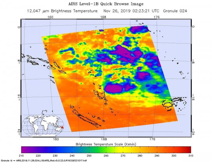
One of the ways NASA researches tropical cyclones is using infrared data that provides temperature information. Cloud top temperatures identify where the strongest storms are located. The stronger the storms, the higher they extend into the troposphere, and the colder the cloud top temperatures.

On Nov. 26 at 0224 UTC (Nov. 25 at 9:24 p.m. EST) NASA’s Aqua satellite analyzed the storm using the Atmospheric Infrared Sounder or AIRS instrument. The AIRS imagery showed the strongest storms were southeast of the center. In those areas, AIRS found coldest cloud top temperatures as cold as or colder 210 Kelvin minus 81 degrees Fahrenheit (minus 63.1 degrees Celsius). NASA research has shown that cloud top temperatures that cold indicate strong storms that have the capability to create heavy rain.

Animated enhanced infrared satellite imagery shows that convection (rising air that forms the thunderstorms that make up a tropical cyclone) is rapidly decaying. That means that thunderstorms cannot form easily. The bulk of the clouds and showers are being pushed to the southeast of the low-level center of circulation by northwesterly winds.

Tropical cyclones do not always have uniform strength, and some sides have stronger sides than others, so knowing where the strongest sides of the storms are located helps forecasters. NASA then provides data to tropical cyclone meteorologists so they can incorporate it in their forecasts.

At 10 a.m. EST (1500 UTC), the Joint Typhoon Warning Center (JTWC) noted that Rita was located near latitude 14.4 degrees south and longitude 169.6 degrees east, about 212 nautical miles north-northeast of Port Vila, Vanuatu. Rita was moving to the south-southwest and had maximum sustained winds of 35 knots (40 mph/65 kph). Rita was moving to the southeast and away from the islands of Vanuatu.

The National Disaster Management Office (NDMO) advises that a Yellow Alert is in effect for people in Penama and Malampa provinces.  Strong to gale force winds may be expected to the east of Penama, Malampa and Shefa Provinces.

On Wednesday, Nov. 27, 2019, the Vanuatu Meteorology and Geo-Hazards Department (VMGD), Port Vila, Vanuatu, said, “Heavy rainfalls are expected over the eastern parts of Penama, Malampa and Shefa province tonight and continuing tomorrow. A Marine strong wind warning for all coastal waters is current. High Seas warning is also current for open waters of Vanuatu close to the system.”

The JTWC expects Rita will dissipate over the next day.

Typhoons and hurricanes are the most powerful weather event on Earth. NASA’s expertise in space and scientific exploration contributes to essential services provided to the American people by other federal agencies, such as hurricane weather forecasting.

The AIRS instrument is one of six instruments flying on board NASA’s Aqua satellite, launched on May 4, 2002.

For updated forecasts from the VMGD website: http://www.vmgd.gov.vu

###

Media Contact
Rob Gutro
[email protected]

Original Source

https://blogs.nasa.gov/hurricanes/2019/11/26/rita-southern-pacific-ocean-2/

Tags: Atmospheric ChemistryAtmospheric ScienceClimate ChangeClimate ScienceEarth ScienceMeteorologyTechnology/Engineering/Computer ScienceTemperature-Dependent PhenomenaWeather/Storms
Share12Tweet8Share2ShareShareShare2

Related Posts

blank

Circ_0000847 Drives Colorectal Cancer via IGF2BP2 Binding

August 22, 2025
Sensitive Surfaces and Keen Senses: Innovative Robotics Detect Threats Before Impact

Sensitive Surfaces and Keen Senses: Innovative Robotics Detect Threats Before Impact

August 22, 2025

ATOX1 Drives Hepatocellular Carcinoma Progression by Activating the c-Myb/PI3K/AKT Signaling Pathway

August 22, 2025

Unraveling Fat Maps: Microfluidics and Mass Spectrometry Illuminate Lipid Landscapes in Tiny Worms

August 22, 2025
Please login to join discussion

POPULAR NEWS

  • blank

    Molecules in Focus: Capturing the Timeless Dance of Particles

    141 shares
    Share 56 Tweet 35
  • New Drug Formulation Transforms Intravenous Treatments into Rapid Injections

    114 shares
    Share 46 Tweet 29
  • Neuropsychiatric Risks Linked to COVID-19 Revealed

    81 shares
    Share 32 Tweet 20
  • Modified DASH Diet Reduces Blood Sugar Levels in Adults with Type 2 Diabetes, Clinical Trial Finds

    60 shares
    Share 24 Tweet 15

About

We bring you the latest biotechnology news from best research centers and universities around the world. Check our website.

Follow us

Recent News

Circ_0000847 Drives Colorectal Cancer via IGF2BP2 Binding

Sensitive Surfaces and Keen Senses: Innovative Robotics Detect Threats Before Impact

ATOX1 Drives Hepatocellular Carcinoma Progression by Activating the c-Myb/PI3K/AKT Signaling Pathway

  • Contact Us

Bioengineer.org © Copyright 2023 All Rights Reserved.

Welcome Back!

Login to your account below

Forgotten Password?

Retrieve your password

Please enter your username or email address to reset your password.

Log In
No Result
View All Result
  • Homepages
    • Home Page 1
    • Home Page 2
  • News
  • National
  • Business
  • Health
  • Lifestyle
  • Science

Bioengineer.org © Copyright 2023 All Rights Reserved.