• HOME
  • NEWS
  • EXPLORE
    • CAREER
      • Companies
      • Jobs
    • EVENTS
    • iGEM
      • News
      • Team
    • PHOTOS
    • VIDEO
    • WIKI
  • BLOG
  • COMMUNITY
    • FACEBOOK
    • INSTAGRAM
    • TWITTER
Monday, September 8, 2025
BIOENGINEER.ORG
No Result
View All Result
  • Login
  • HOME
  • NEWS
  • EXPLORE
    • CAREER
      • Companies
      • Jobs
        • Lecturer
        • PhD Studentship
        • Postdoc
        • Research Assistant
    • EVENTS
    • iGEM
      • News
      • Team
    • PHOTOS
    • VIDEO
    • WIKI
  • BLOG
  • COMMUNITY
    • FACEBOOK
    • INSTAGRAM
    • TWITTER
No Result
View All Result
Bioengineer.org
No Result
View All Result
Home NEWS Science News

NASA finds heavy rain potential in Tropical Storm Hikaa

Bioengineer by Bioengineer
September 23, 2019
in Science News
Reading Time: 2 mins read
0
IMAGE
Share on FacebookShare on TwitterShare on LinkedinShare on RedditShare on Telegram

IMAGE

Credit: Credit: NASA JPL/Heidar Thrastarson

The Northern Indian Ocean has generated a new tropical cyclone. NASA provided an infrared look a recently formed Tropical Storm Hikaa, moving through the Arabian Sea.

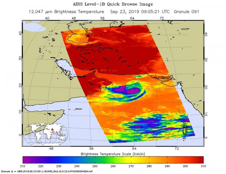
One of the ways NASA researches tropical cyclones is by using infrared data that provides temperature information. The AIRS instrument aboard NASA’s Aqua satellite captured a look at those temperatures in Hikaa and gave insight into the storm’s rainfall potential. Cloud top temperatures provide information to forecasters about where the strongest storms are located within a tropical cyclone. Tropical cyclones do not always have uniform strength, and some sides have stronger sides than others. The stronger the storms, the higher they extend into the troposphere, and the colder the cloud temperatures are.

NASA provides data to forecasters around the world so they can incorporate that data into their forecasting.

On Sept. 23 at 4:05 a.m. EDT (0905 UTC) NASA’s Aqua satellite analyzed the storm using the Atmospheric Infrared Sounder or AIRS instrument. AIRS found coldest cloud top temperatures as cold as or colder than minus 63 degrees Fahrenheit (minus 53 degrees Celsius) from west to south around Hikaa’s center. NASA research has shown that cloud top temperatures that cold indicate strong storms that have the capability to create heavy rain.

At 11 a.m. EDT (1500 UTC), The Joint Typhoon Warning Center said the center of Tropical Hikaa was located near latitude 20.2 degrees north and longitude 65.5 degrees east. It is located about 265 miles east of Masirah Island, Oman. The tropical storm was moving toward the west. Maximum sustained winds are near 60 knots (69 mph/111 kph) with higher gusts.

Hikaa will strengthen slightly before making landfall in Oman after a day or so.

The AIRS instrument is one of six instruments flying onboard NASA’s Aqua satellite, launched on May 4, 2002.

Hurricanes are the most powerful weather event on Earth. NASA’s expertise in space and scientific exploration contributes to essential services provided to the American people by other federal agencies, such as hurricane weather forecasting.

###

Media Contact
Rob Gutro
[email protected]

Original Source

https://blogs.nasa.gov/hurricanes/2019/09/23/hikaa-northern-indian-ocean/

Tags: Atmospheric ChemistryAtmospheric ScienceClimate ChangeClimate ScienceEarth ScienceMeteorologyTechnology/Engineering/Computer ScienceTemperature-Dependent PhenomenaWeather/Storms
Share12Tweet8Share2ShareShareShare2

Related Posts

Frailty Drives Gut Microbiome Imbalance and Heightens Post-Surgical GI Risks

September 8, 2025

BMS-986504 Shows Lasting Efficacy in MTAP-Deleted NSCLC, Targeting EGFR and ALK-Positive Tumors

September 8, 2025

EA5181 Phase 3 Trial Shows No Overall Survival Advantage for Concurrent Plus Consolidative Durvalumab Over Consolidation Alone in Unresectable Stage 3 NSCLC

September 8, 2025

Closed-Loop Recycling of Mixed Polyesters via Catalysis

September 8, 2025
Please login to join discussion

POPULAR NEWS

  • blank

    Breakthrough in Computer Hardware Advances Solves Complex Optimization Challenges

    150 shares
    Share 60 Tweet 38
  • New Drug Formulation Transforms Intravenous Treatments into Rapid Injections

    116 shares
    Share 46 Tweet 29
  • First Confirmed Human Mpox Clade Ib Case China

    56 shares
    Share 22 Tweet 14
  • A Laser-Free Alternative to LASIK: Exploring New Vision Correction Methods

    47 shares
    Share 19 Tweet 12

About

We bring you the latest biotechnology news from best research centers and universities around the world. Check our website.

Follow us

Recent News

Frailty Drives Gut Microbiome Imbalance and Heightens Post-Surgical GI Risks

BMS-986504 Shows Lasting Efficacy in MTAP-Deleted NSCLC, Targeting EGFR and ALK-Positive Tumors

EA5181 Phase 3 Trial Shows No Overall Survival Advantage for Concurrent Plus Consolidative Durvalumab Over Consolidation Alone in Unresectable Stage 3 NSCLC

  • Contact Us

Bioengineer.org © Copyright 2023 All Rights Reserved.

Welcome Back!

Login to your account below

Forgotten Password?

Retrieve your password

Please enter your username or email address to reset your password.

Log In
No Result
View All Result
  • Homepages
    • Home Page 1
    • Home Page 2
  • News
  • National
  • Business
  • Health
  • Lifestyle
  • Science

Bioengineer.org © Copyright 2023 All Rights Reserved.