Credit: NASA JPL/Heidar Thrastarson
NASA’s Aqua satellite provided a near visible image and analyzed the cloud top temperatures in Tropical Cyclone Blake, located along the northern coast of Western Australia. Tropical Cyclone Blake is just north of Broome, a coastal town in the Kimberley region of Western Australia.
On January 6, the Australian Bureau of Meteorology posted warnings and watches for Blake. The Warning zone stretches from Cockatoo Island to De Grey. The Watch zone extends from De Grey to Whim Creek, including Port Hedland and extending inland to include Marble Bar and Nullagine.
In addition, there are several community alerts in effect. A Yellow alert is in effect for residents in or near communities from Cockatoo Island to Bidyadanga, including Bidyadanga and Broome but not including Derby, need to take action and get ready to shelter from a cyclone. A Blue alert is in effect for residents in or near communities from Bidyadanga to De Grey, need to prepare for cyclonic weather.
One of the ways NASA researches tropical cyclones is using infrared data that provides temperature information. Cloud top temperatures identify where the strongest storms are located. The stronger the storms, the higher they extend into the troposphere, and they have the colder cloud temperatures.
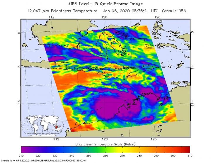
On Jan. 6 at 12:35 a.m. EST (0535 UTC/1:35 p.m. AWST) NASA’s Aqua satellite analyzed Tropical Cyclone Blake’s cloud top temperatures using the Atmospheric Infrared Sounder or AIRS instrument. AIRS showed the strongest storms contained cloud top temperatures as cold as or colder than 210 Kelvin (minus 81 degrees Fahrenheit/minus 63.1 degrees Celsius) around the center. NASA research has shown that cloud top temperatures that cold indicate strong storms that have the capability to create heavy rain.
Tropical cyclones do not always have uniform strength, and some sides have stronger sides than others, so knowing where the strongest sides of the storms are located helps forecasters. NASA then provides data to tropical cyclone meteorologists so they can incorporate it in their forecasts. Satellite data has shown that the strongest storms associated with the system is currently confined to the southwestern portion of the circulation, and the Joint Typhoon Warning Center noted the low-level circulation remains robust.
On January 6 at 10 a.m. EST (1500 UTC), the Joint Typhoon Warning Center noted that Blake has maximum sustained winds near 50 knots (48 mph/93 kph). Forecasters believe that Blake has peaked in intensity and after today, it will begin a weakening trend. Blake was centered near 17.7 degrees south latitude and 121.9 degrees east longitude, approximately 32 nautical miles north-northwest of Broome, Australia. Blake has tracked south-southwestward and is forecast to continue moving in that general direction.
Forecasters at JTWC anticipate landfall to the east of Port Hedland between 24 and 26 hours (from Jan. 6 at 10 a.m. EST/1500 UTC). After landfall, the system is expected to continue moving inland and slowly dissipate by 72 hours.
Tropical cyclones are the most powerful weather event on Earth. NASA’s expertise in space and scientific exploration contributes to essential services provided to the American people by other federal agencies, such as hurricane weather forecasting.
The AIRS instrument is one of six instruments flying on board NASA’s Aqua satellite, launched on May 4, 2002.
###
Media Contact
Rob Gutro
[email protected]
Original Source
https:/


