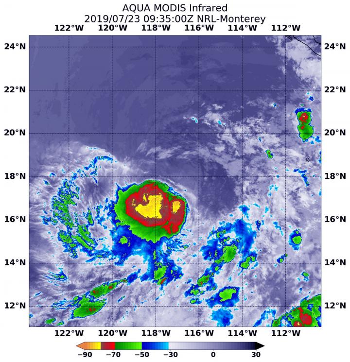
Credit: NASA/NRL
Satellite imagery on July 22 showed that wind shear was preventing the Eastern Pacific Ocean’s Tropical Depression 5 from consolidating and strengthening. Infrared imagery from NASA’s Aqua satellite on July 23 showed that the wind shear eased and the storm was able to strengthen.
NASA’s Aqua satellite used infrared light to analyze the strength of storms circled the center of circulation, a change from 24 hours before when wind shear pushed them away from the center. Now, the storm appears much more circular.
Infrared data provides temperature information, and the strongest thunderstorms that reach high into the atmosphere have the coldest cloud top temperatures.
On July 23 at 5:35 a.m. EDT (0935 UTC), the Moderate Imaging Spectroradiometer or MODIS instrument that flies aboard NASA’s Aqua satellite gathered infrared data on the strengthened Tropical Storm Dalila. Strongest thunderstorms had cloud top temperatures as cold as minus 80 degrees Fahrenheit (minus 62.2 Celsius). Cloud top temperatures that cold indicate strong storms with the potential to generate heavy rainfall.
At 5 a.m. EDT (0900 UTC) on July 23, the National Hurricane Center (NHC) the center of newly formed Tropical Storm Dalila was located near latitude 18.0 degrees north and longitude 117.3 degrees west. That is about 585 miles (945) km) southwest of the southern tip of Baja California, Mexico. There are no coastal watches or warnings in effect.
Maximum sustained winds have increased to near 40 mph (65 kph) with higher gusts. The estimated minimum central pressure is 1005 millibars. Dalila is moving toward the north-northwest near 7 mph (11 kph). A turn to the northwest is anticipated on Wednesday, followed by a movement more to the west-northwest on Thursday and Friday.
NHC noted, “Some weakening is forecast to begin on Wednesday, and Dalila could degenerate into a remnant low on Thursday.”
For updated forecasts, visit: https:/
###
Media Contact
Rob Gutro
[email protected]
Original Source
https:/


