Credit: NASA/NRL
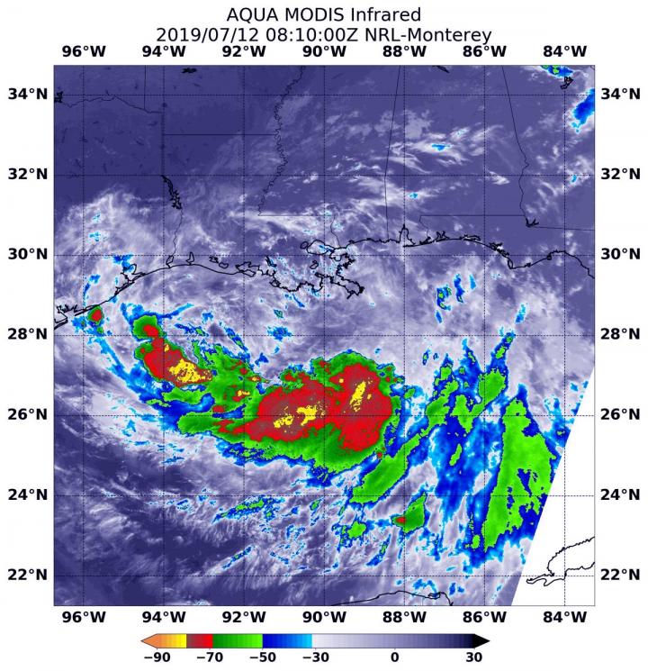
Infrared imagery from NASA’s Aqua satellite shows that Tropical Storm Barry doesn’t look like a typical strong tropical cyclone. Imagery revealed that Barry is elongated and the strongest storms were south of it’s stretched out center of circulation.
Warnings and Watches
At 8 a.m. EDT (1200 UTC) on Friday, July 12, NOAA’s National Hurricane Center (NHC) in Miami, Florida said that Barry is moving slowly to the west-northwest in the Gulf of Mexico, and south of the coast of southeastern Louisiana. NHC warns of dangerous storm surge, heavy rains, and wind conditions expected across the north-central Gulf coast.
Many warnings and watches are in effect as Barry hugs that northern Gulf coast, hammering the region. A Hurricane Warning is in effect from Intracoastal City to Grand Isle, Louisiana. A Tropical Storm Warning is in effect from the mouth of the Pearl River to Grand Isle, La. and for Lake Pontchartrain and Lake Maurepas including metropolitan New Orleans, and from Intracoastal City, Louisiana to Cameron, Louisiana.
A Storm Surge Warning is in effect from Intracoastal City to Shell Beach, Louisiana. A Storm Surge Watch is in effect from Shell Beach to the Mississippi/Alabama border and for Lake Pontchartrain. A Hurricane Watch is in effect from the mouth of the Mississippi River to Grand Isle, La. and for Intracoastal City to Cameron, La. A Tropical Storm Watch is in effect from east of the Mouth of the Pearl River to the Mississippi/Alabama border.
Satellite Imagery
NASA’s Aqua satellite used infrared light to analyze the strength of storms and found the bulk of them in the southern quadrant. Infrared data provides temperature information, and the strongest thunderstorms that reach high into the atmosphere have the coldest cloud top temperatures.
On July 12 at 4:10 a.m. EDT (0810 UTC), the Moderate Imaging Spectroradiometer or MODIS instrument that flies aboard NASA’s Aqua satellite gathered infrared data on Tropical Storm Barry. Strongest thunderstorms had cloud top temperatures as cold as minus 70 degrees Fahrenheit (minus 56.6 Celsius). Cloud top temperatures that cold indicate strong storms with the potential to generate heavy rainfall. Those strongest storms were south and southeast of the center of the elongated circulation.
The NHC said, “Barry does not have the typical presentation of a tropical cyclone on satellite imagery at this time. The cloud pattern consists of a cyclonically curved convective band on the southern semicircle, and the system is devoid of an inner convective core near the center. Barry is an asymmetric storm with most of the tropical-storm-force winds occurring in the eastern semicircle. Tropical-storm-force winds extend outward up to 175 miles (280 km) to the east of the center.”
Barry’s Status on July 12, 2019 at 8 a.m. EDT
On July 12 at 8 a.m. EDT (1200 UTC), the National Hurricane Center (NHC) said the broad circulation center of Tropical Storm Barry was located near latitude 28.2 degrees north and longitude 90.3 degrees west. The minimum central pressure based on the Hurricane Hunter aircraft data is 998 millibars (29.47 inches).
Barry is moving toward the west-northwest near 5 mph (7 kph). A track toward the northwest is expected to begin later in the day on Friday, July 12, followed by a turn toward the north on Saturday, July 13.
Reports from NOAA and Air Force Reserve Hurricane Hunter aircraft indicate that the maximum sustained winds remain near 50 mph (85 kph) with higher gusts. Some strengthening is expected during the next day or so, and Barry could become a hurricane tonight or early on July 13 when the center is near the Louisiana coast. After landfall, weakening is expected after Barry moves inland.
Barry’s Path Forward
On the NHC forecast track, the center of Barry will be near or over the central or southeastern coast of Louisiana tonight or Saturday, July 13 and then move inland over the Lower Mississippi Valley on Sunday, July 14.
Key Messages from the National Hurricane Center
- There is a danger of life-threatening storm surge inundation along the coast of southern and southeastern Louisiana where a Storm Surge Warning is in effect. The highest storm surge inundation is expected between Intracoastal City and Shell Beach. Residents in these areas should listen to any advice given by local officials.
- The slow movement of Barry will result in a long duration heavy rainfall and flood threat along the central Gulf Coast and inland through the lower Mississippi Valley through the weekend into early next week. Flash flooding and river flooding will become increasingly likely, some of which may be significant, especially along and east of the track of the system.
- Hurricane conditions are expected along a portion of the coast of Louisiana, where a Hurricane Warning has been issued. Residents in these areas should rush their preparations to completion, as tropical storm conditions are expected to arrive in the warning area by Friday morning.
###
For updated forecasts, visit: https:/
Rob Gutro
NASA’s Goddard Space Flight Center.
Media Contact
Rob Gutro
[email protected]
Original Source
https:/
