• HOME
  • NEWS
  • EXPLORE
    • CAREER
      • Companies
      • Jobs
    • EVENTS
    • iGEM
      • News
      • Team
    • PHOTOS
    • VIDEO
    • WIKI
  • BLOG
  • COMMUNITY
    • FACEBOOK
    • INSTAGRAM
    • TWITTER
Saturday, August 2, 2025
BIOENGINEER.ORG
No Result
View All Result
  • Login
  • HOME
  • NEWS
  • EXPLORE
    • CAREER
      • Companies
      • Jobs
        • Lecturer
        • PhD Studentship
        • Postdoc
        • Research Assistant
    • EVENTS
    • iGEM
      • News
      • Team
    • PHOTOS
    • VIDEO
    • WIKI
  • BLOG
  • COMMUNITY
    • FACEBOOK
    • INSTAGRAM
    • TWITTER
No Result
View All Result
Bioengineer.org
No Result
View All Result
Home NEWS Science News

NASA finds a wispy, wind-sheared Tropical Depression 06W

Bioengineer by Bioengineer
August 11, 2020
in Science News
Reading Time: 2 mins read
0
Share on FacebookShare on TwitterShare on LinkedinShare on RedditShare on Telegram

IMAGE

Credit: Credit: NASA/NRL

NASA’s Terra satellite revealed that a wispy looking Tropical Depression 06W in the Northwestern Pacific Ocean was being battered by wind shear. That wind shear is not expected to wane and the storm is expected to weaken.

Tropical Depression 06W formed two days ago on August 9 by 11 a.m. EDT (1500 UTC) near latitude 26.1 degrees north and longitude 147.6 east, about 250 nautical miles east-northeast of Iwo To Island, Japan. 06W briefly strengthened to a tropical storm by 5 p.m. EDT (2100 UTC) when maximum sustained winds reached 45 knots (52 mph/83 kph). By Aug. 10 at 11 a.m. EDT (1500 UTC) the storm had weakened back to tropical depression status.

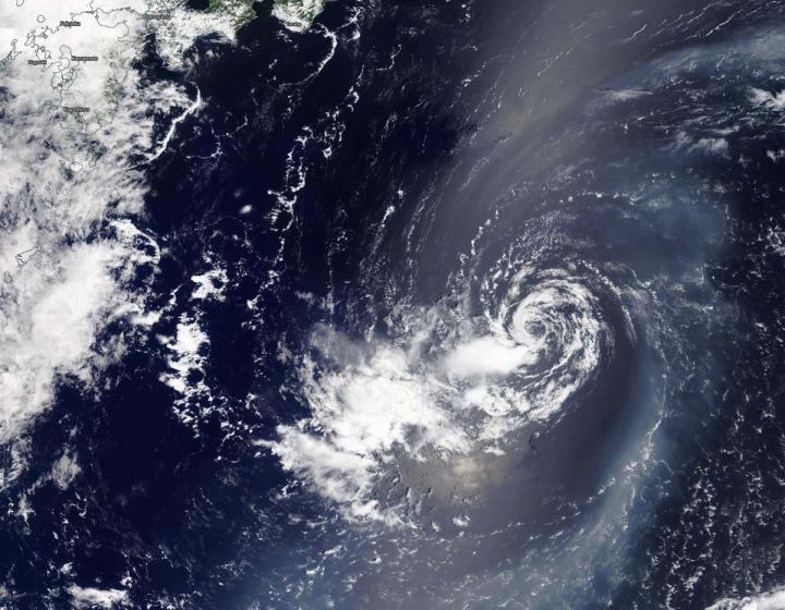
On Aug. 11, 2020, the Moderate Resolution Imaging Spectroradiometer or MODIS instrument that flies aboard NASA’s Terra satellite provided forecasters at the Joint Typhoon Warning Center in Honolulu, Hawaii with a visible image of Tropical Depression 06W. The image showed a ring of wispy clouds around a fully-exposed, well-defined, low-level center of circulation. It also showed that any precipitation and thunderstorms were pushed to the south-southwest of the center from vertical wind shear.

Vertical wind shear, that is, winds outside of a tropical cyclone at different heights in the atmosphere (the troposphere) push against a tropical cyclone and tear it apart. Winds from the north-northeast were affecting 06W. In addition, dry air was moving into the storm and sapping the development of the thunderstorms that make up a tropical cyclone.

At 5 a.m. EDT (0900 UTC) on Aug. 11, the center of Tropical Depression 06W was located near latitude 26.6 degrees north and longitude 140.5 degrees east, about 681 nautical miles east of Kadena Air Base, Okinawa Island, Japan. 06W was moving to the west and had maximum sustained winds near 25 knots (29 mph/46 kph).

The Joint Typhoon Warning Center (JTWC) forecast notes that 06W will continue to move west and weaken before dissipating after a few days.

About NASA’s Worldview and Terra Satellite

NASA’s Earth Observing System Data and Information System (EOSDIS) Worldview application provides the capability to interactively browse over 700 global, full-resolution satellite imagery layers and then download the underlying data. Many of the available imagery layers are updated within three hours of observation, essentially showing the entire Earth as it looks “right now.”

NASA’s Terra satellite is one in a fleet of NASA satellites that provide data for hurricane research.

Tropical cyclones/hurricanes are the most powerful weather events on Earth. NASA’s expertise in space and scientific exploration contributes to essential services provided to the American people by other federal agencies, such as hurricane weather forecasting.

By Rob Gutro
NASA’s Goddard Space Flight Center

###

Media Contact
Rob Gutro
[email protected]

Original Source

https://blogs.nasa.gov/hurricanes/2020/08/11/06w-northwestern-pacific-ocean/

Tags: Atmospheric ChemistryAtmospheric ScienceClimate ChangeClimate ScienceEarth ScienceMeteorologyTechnology/Engineering/Computer ScienceTemperature-Dependent PhenomenaWeather/Storms
Share12Tweet8Share2ShareShareShare2

Related Posts

blank

Serum Markers Predict Atrial Fibrillation in Diabetes

August 2, 2025
blank

Intrapleural Anti-VEGF Boosts Nab-Paclitaxel Efficacy

August 2, 2025

Amyloid Fibrils Connect CHCHD10, CHCHD2 to Neurodegeneration

August 2, 2025

Mapping the Human Hippocampus: Single-Nucleus to Spatial Transcriptomics

August 2, 2025
Please login to join discussion

POPULAR NEWS

  • Blind to the Burn

    Overlooked Dangers: Debunking Common Myths About Skin Cancer Risk in the U.S.

    60 shares
    Share 24 Tweet 15
  • Neuropsychiatric Risks Linked to COVID-19 Revealed

    45 shares
    Share 18 Tweet 11
  • Dr. Miriam Merad Honored with French Knighthood for Groundbreaking Contributions to Science and Medicine

    46 shares
    Share 18 Tweet 12
  • Study Reveals Beta-HPV Directly Causes Skin Cancer in Immunocompromised Individuals

    38 shares
    Share 15 Tweet 10

About

We bring you the latest biotechnology news from best research centers and universities around the world. Check our website.

Follow us

Recent News

Serum Markers Predict Atrial Fibrillation in Diabetes

Intrapleural Anti-VEGF Boosts Nab-Paclitaxel Efficacy

Amyloid Fibrils Connect CHCHD10, CHCHD2 to Neurodegeneration

  • Contact Us

Bioengineer.org © Copyright 2023 All Rights Reserved.

Welcome Back!

Login to your account below

Forgotten Password?

Retrieve your password

Please enter your username or email address to reset your password.

Log In
No Result
View All Result
  • Homepages
    • Home Page 1
    • Home Page 2
  • News
  • National
  • Business
  • Health
  • Lifestyle
  • Science

Bioengineer.org © Copyright 2023 All Rights Reserved.