Credit: Credit: NASA/NRL
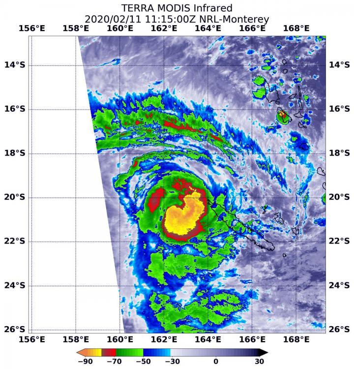
NASA’s Terra satellite passed over the South Pacific Ocean and found a stronger Tropical Cyclone Uesi after obtaining infrared imagery of the storm. Uesi continues moving away from Vanuatu and today is affecting New Caledonia.
Infrared data provides temperature information, and identifies the strongest thunderstorms that reach high into the atmosphere and have the coldest cloud top temperatures. On Feb. 11 at 6:15 a.m. EST (1115 UTC), the Moderate Resolution Imaging Spectroradiometer or MODIS instrument aboard NASA’s Terra satellite gathered that temperature information about Uesi’s cloud tops. MODIS found powerful thunderstorms south and east of the center of circulation where temperatures were as cold as or colder than minus 80 degrees Fahrenheit (minus 62.2 Celsius). Cloud top temperatures that cold indicate strong storms with the potential to generate heavy rainfall.
On Feb. 11, the Vanuatu Meteorology and Geo-Hazards Department (VMGD), in Port Vila issued an update on Uesi. At 7:48 a.m. EST (11:48 p.m. Vanuatu local time), Tropical Cyclone Uesi was located at latitude 19.6 degrees south and longitude 162.6 east, about 435 miles (700 km) west of Tanna. Winds close to the center of the system have increased from near 55 mph (90 kph/50 knots) to 78 mph (125 kph/67 knots), making it equivalent to a Category 1 hurricane. Uesi was moving in a south-southeasterly direction. VMGD said that the potential for the system to recurve and move towards Vanuatu is low.
VMGD’s final advisory on Uesi said, “Isolated heavy rainfalls may still be expected about [the] Vanuatu group today and tonight. Seas will remain very rough with heavy to phenomenal swells over coastal and open waters to the west of the Vanuatu group. Severe weather warning for heavy rainfalls for northern, central and southern provinces, while Marine strong wind warning for all coastal waters are current.”
Meteo France, the forecast entity that provides forecasts for New Caledonia, which is located to the south-southwest of Vanuatu, is now feeling more of the effects from Uesi. On Feb. 11, Meteo France noted, “Uesi continues to move south passing west of Bélep and Grande-Terre a hundred kilometers (62 miles).” Rainbands continue to affect the whole territory and generate large accumulations of rain. As Uesi continues moving toward the south on Feb. 12, it is pulling away from New Caledonia. However, forecasters note that bands of thunderstorms can still bring heavy rainfall and gusty winds on Feb. 11. Highest rainfall is likely especially on the eastern side of the island.
For updates from VMGD’s website: whttp://www.
For updates on New Caledonia’s forecast, visit Meteo France: http://www.
Tropical cyclones/hurricanes are the most powerful weather events on Earth. NASA’s expertise in space and scientific exploration contributes to essential services provided to the American people by other federal agencies, such as hurricane weather forecasting.
###
Media Contact
Rob Gutro
[email protected]
Original Source
https:/


