Credit: NASA/NRL
Tropical Storm Barry made landfall mid-day on July 13, but infrared satellite imagery from NASA early on July 14 continued to show the heaviest rainmaking storms were still off-shore. NASA’s Aqua satellite analyzed cloud top temperatures in the storm which gave an indication of the storm’s strength.
Barry reached Category 1 hurricane strength for about three hours in the late morning and early afternoon on July 13. Barry made landfall around 2 p.m. EDT as a strong tropical storm about 5 miles (10 km) northeast of Intracoastal City, La. After making landfall, Barry weakened back to a tropical storm.
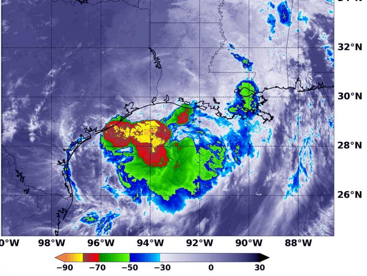
At 3:55 a.m. EDT (0755 UTC) on July 14, the MODIS or Moderate Resolution Imaging Spectroradiometer instrument aboard NASA’s Aqua satellite looked at Tropical Strom Barry infrared light. MODIS found coldest cloud tops had temperatures near minus 80 degrees Fahrenheit (minus 62.2 degrees Celsius) still off-shore from south central Louisiana. Those storms were north of center of the tropical storm. Storms with temperatures that cold are indicative of strong storms and have been shown to have the capability to generate heavy rainfall.
The heavy rainfall exacerbated by the slow movement is creating flooding dangers. Life-threatening flash flooding and significant river flooding are still expected along Barry’s path inland from Louisiana up through the lower Mississippi Valley, through at least Monday. Widespread rainfall of 4 inches or more is expected, with embedded areas of significantly heavier rain that will lead to rapid water rises.
Barry’s Status on July 14, 2019
At 8 a.m. EDT (1200 UTC) on Sunday, July 14, 2019 the National Hurricane Center or NHC said the center of Tropical Storm Barry was located near latitude 31.4 degrees north and longitude 93.4 degrees west. That puts Barry’s center just 5 miles (10 km) west of Peason Ridge, Louisiana. Barry is moving toward the north near 6 mph (10 km/h), and this general motion is expected to continue through Monday.
NOAA Doppler weather radar data and surface observations indicate that maximum sustained winds remain near 45 mph (75 kph) with higher gusts. These winds are occurring near the coast to the southeast of the center. Tropical-storm-force winds extend outward up to 175 miles (280 km) mainly over water to the southeast of the center.
The estimated minimum central pressure based on surface observations is 1005 mb (29.68 inches).
Warnings and Watches in Effect
The NHC posted many warnings and watches for Barry on July 14. A Tropical Storm Warning is in effect from Morgan City to Cameron, Louisiana and a Storm Surge Warning is in effect from Intracoastal City to the mouth of Atchafalaya River. A Tropical Storm warning means that tropical storm conditions are expected somewhere within the warning area.
Moving Further Inland
Weakening is expected as the center moves farther inland, and Barry is forecast to weaken to a tropical depression later today. Two computer models, the GFS and ECMWF models suggest that Barry should lose much of its deep convection and become a remnant low pressure area in 36 to 48 hours and dissipate entirely shortly after that over the Middle Mississippi Valley.
On the forecast track, the National Hurricane Center said the center of Barry will move across the western and northern portions of Louisiana today, and over Arkansas tonight and Monday.
###
For updated forecasts, visit: http://www.
Rob Gutro
NASA’s Goddard Space Flight Center
Media Contact
Rob Gutro
[email protected]
Original Source
https:/
