• HOME
  • NEWS
  • EXPLORE
    • CAREER
      • Companies
      • Jobs
    • EVENTS
    • iGEM
      • News
      • Team
    • PHOTOS
    • VIDEO
    • WIKI
  • BLOG
  • COMMUNITY
    • FACEBOOK
    • INSTAGRAM
    • TWITTER
Saturday, August 2, 2025
BIOENGINEER.ORG
No Result
View All Result
  • Login
  • HOME
  • NEWS
  • EXPLORE
    • CAREER
      • Companies
      • Jobs
        • Lecturer
        • PhD Studentship
        • Postdoc
        • Research Assistant
    • EVENTS
    • iGEM
      • News
      • Team
    • PHOTOS
    • VIDEO
    • WIKI
  • BLOG
  • COMMUNITY
    • FACEBOOK
    • INSTAGRAM
    • TWITTER
No Result
View All Result
Bioengineer.org
No Result
View All Result
Home NEWS Science News

NASA examines tropical storm Arthur’s rainfall as it transitions

Bioengineer by Bioengineer
May 19, 2020
in Science News
Reading Time: 2 mins read
0
Share on FacebookShare on TwitterShare on LinkedinShare on RedditShare on Telegram

IMAGE

Credit: NASA/JAXA/NRL

When the Global Precipitation Measurement mission or GPM core satellite passed over the western North Atlantic Ocean, it captured rainfall data on Tropical Storm Arthur as the storm was transitioning into an extra-tropical storm.

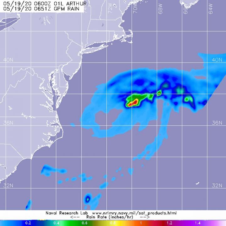
The GPM’s core satellite passed over Arthur on May 19 at 2:51 a.m. EDT (0651 UTC) and found the heaviest rainfall on the northeastern side of the storm falling at a rate of over 25mm (over 1 inch) per hour. Lighter rainfall rates were measured throughout the rest of the storm. Forecasters at NOAA’s National Hurricane Center or NHC incorporate the rainfall data into their forecasts.

NHC forecasters noted at 5 a.m. EDT (0900 UTC) on May 19, “Arthur’s cloud pattern has continued to take on a generally post-tropical appearance, though a recent convective burst near its center suggests that it isn’t quite post-tropical yet. Satellite imagery and earlier scatterometer data also indicate the presence of a developing warm front near the cyclone’s center, and this could be contributing the development of the aforementioned convective burst.”

NHC said the center of Tropical Storm Arthur was located near latitude 37.0 north, longitude 70.6 west, about 300 miles (485 km) east-northeast of Cape Hatteras, North Carolina. Arthur was moving toward the east-northeast near 15 mph (24 kph). Maximum sustained winds are near 60 mph (95 kph) with higher gusts. The estimated minimum central pressure is 991 millibars.

The NHC cautions that swells generated by Arthur are expected to affect portions of the mid-Atlantic and southeast U.S. coasts during the next day or two. These swells could cause life-threatening surf and rip current conditions.

Arthur is forecast to become post-tropical later today and is forecast to slow down and turn toward the south in another day or so. Arthur is expected to dissipate by the end of the week.

A Post-Tropical Storm is a generic term for a former tropical cyclone that no longer possesses sufficient tropical characteristics to be considered a tropical cyclone. Former tropical cyclones that have become extratropical, subtropical, or remnant lows are all three classes of post-tropical cyclones. In any case, they no longer possesses sufficient tropical characteristics to be considered a tropical cyclone. However, post-tropical cyclones can continue carrying heavy rains and produce high winds.

###

Hurricanes/tropical cyclones are the most powerful weather events on Earth. NASA’s expertise in space and scientific exploration contributes to essential services provided to the American people by other federal agencies, such as hurricane weather forecasting.

GPM is a joint mission between NASA and the Japan Aerospace Exploration Agency, JAXA.

For updated forecasts, visit: http://www.nhc.noaa.gov

By Rob Gutro

NASA Goddard Space Flight Center

Media Contact
Rob Gutro
[email protected]

Original Source

https://blogs.nasa.gov/hurricanes/2020/05/19/arthur-was-90l-atlantic-ocean-2/

Tags: Atmospheric ChemistryAtmospheric ScienceClimate ChangeClimate ScienceEarth ScienceMeteorologyTechnology/Engineering/Computer ScienceTemperature-Dependent PhenomenaWeather/Storms
Share12Tweet8Share2ShareShareShare2

Related Posts

Boosting ADMET Predictions for Key CYP450s

Boosting ADMET Predictions for Key CYP450s

August 2, 2025
blank

Saliva Exosome Proteins and Lipids Diagnose Esophageal Cancer

August 2, 2025

Feasibility of Range-Compensated Proton Arc Therapy

August 2, 2025

Fermentable Carbs and Metformin Boost Prediabetes Control

August 2, 2025
Please login to join discussion

POPULAR NEWS

  • Blind to the Burn

    Overlooked Dangers: Debunking Common Myths About Skin Cancer Risk in the U.S.

    60 shares
    Share 24 Tweet 15
  • Neuropsychiatric Risks Linked to COVID-19 Revealed

    44 shares
    Share 18 Tweet 11
  • Dr. Miriam Merad Honored with French Knighthood for Groundbreaking Contributions to Science and Medicine

    46 shares
    Share 18 Tweet 12
  • Study Reveals Beta-HPV Directly Causes Skin Cancer in Immunocompromised Individuals

    38 shares
    Share 15 Tweet 10

About

We bring you the latest biotechnology news from best research centers and universities around the world. Check our website.

Follow us

Recent News

Boosting ADMET Predictions for Key CYP450s

Saliva Exosome Proteins and Lipids Diagnose Esophageal Cancer

Feasibility of Range-Compensated Proton Arc Therapy

  • Contact Us

Bioengineer.org © Copyright 2023 All Rights Reserved.

Welcome Back!

Login to your account below

Forgotten Password?

Retrieve your password

Please enter your username or email address to reset your password.

Log In
No Result
View All Result
  • Homepages
    • Home Page 1
    • Home Page 2
  • News
  • National
  • Business
  • Health
  • Lifestyle
  • Science

Bioengineer.org © Copyright 2023 All Rights Reserved.