Credit: Credit: NASA Goddard
NASA estimated extreme rainfall over eastern Texas from the remnants of Tropical Depression Imelda using a NASA satellite rainfall product that incorporates data from satellites and observations.
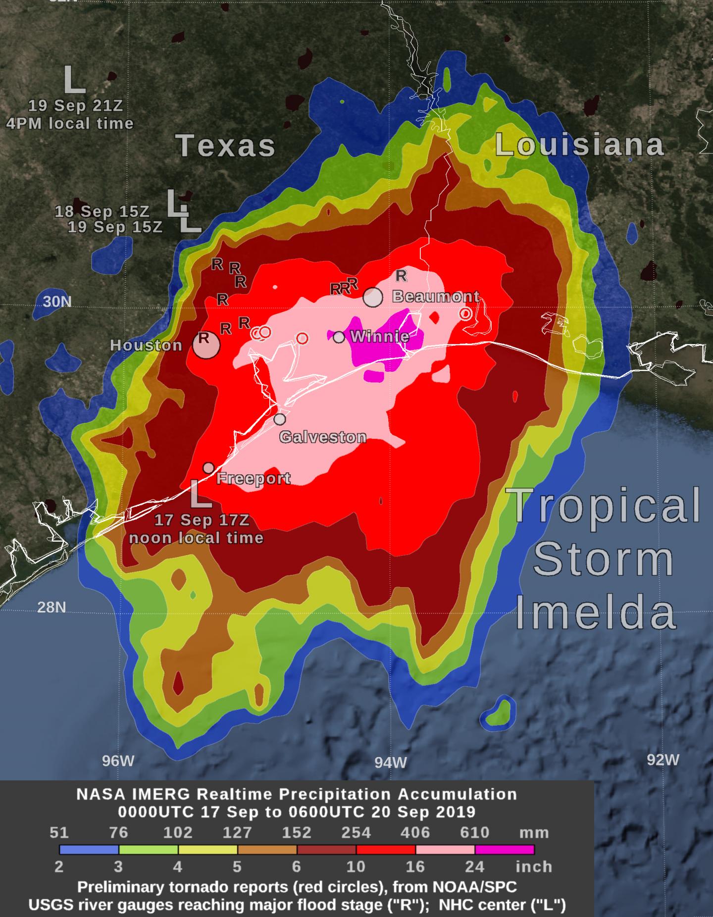
NASA’s Integrated Multi-satellitE Retrievals for GPM or IMERG, which is a NASA satellite rainfall product, estimated that by Friday morning, September 20, Tropical Storm Imelda had dropped over 24 inches of rain between Beaumont and Houston, Texas. Estimates of between 16 and 24 inches have fallen between Freeport and Beaumont, and 6 inches and more over a large area between southwestern Louisiana and Palacios, Texas. An image showing these rainfall totals was created at NASA’s Goddard Space Flight Center in Greenbelt, Md.
This near-real time rain estimate comes from the NASA’s IMERG, which combines observations from a fleet of satellites, in near-real time, to provide near-global estimates of precipitation every 30 minutes. By combining NASA precipitation estimates with other data sources, we can gain a greater understanding of major storms that affect our planet.
If one compares the IMERG satellite-based rain estimate to that from a National Weather Service ground radar, one sees that IMERG correctly identified the large region of heavy rainfall near Beaumont, but IMERG failed to resolve an extremely narrow band of heavy rainfall along Galveston Island. Such good detection of large rain features in real-time would be impossible if the IMERG merely reported the precipitation observed by the periodic overflights of various agencies’ satellites.
Instead, what the IMERG does is “morph” high-quality satellite observations along the direction of the steering winds to deliver information about rain at times and places where such satellite overflights did not occur. Information morphing is particularly important over the majority of the world’s surface that lacks ground-radar coverage. Basically, IMERG fills in the blanks between weather observation stations.
The NASA image also identified where the rainfall from the remnant of Imelda caused a U.S. Geological Survey river gauge to swell to “major flood” stage. “Major” flood generally means that nearby homes and roads were flooded. In addition, there were several preliminary reports of Imelda-spawned tornadoes on Wednesday and Thursday, September 18 and 19.
NOAA’s National Weather Service noted on Sept. 20, “Intense tropical rainfall continues in portions of Southeast Texas and Southwest Louisiana from the remnants of Imelda. These additional rains will only compound ongoing issues with flooding. The heavy rain focus will gradually shift to the Arkansas-Louisiana-Texas region on Friday, Sept. 20.”
Hurricanes are the most powerful weather event on Earth. NASA’s expertise in space and scientific exploration contributes to essential services provided to the American people by other federal agencies, such as hurricane weather forecasting.
For more information about NASA’s IMERG, visit: https:/
For local forecasts, visit: http://www.
###
Media Contact
Rob Gutro
[email protected]
Original Source
https:/


